
ファイル:World Köppen Map.jpg

このプレビューのサイズ: 800 × 530 ピクセル。 その他の解像度: 320 × 212 ピクセル | 640 × 424 ピクセル | 1,024 × 679 ピクセル | 1,280 × 848 ピクセル | 2,560 × 1,697 ピクセル | 4,231 × 2,804 ピクセル。
元のファイル (4,231 × 2,804 ピクセル、ファイルサイズ: 1.25メガバイト、MIME タイプ: image/jpeg)
ウィキメディア・コモンズのファイルページにある説明を、以下に表示します。
|

|
このmeteorology画像は、ベクターイメージである SVG ファイルとして再作成されるべきです。これにはいくつかの利点があります。詳しくはCommons:Media for cleanupを参照してください。この画像の SVG 形式がすでに利用可能である場合は、アップロードしてください。アップロード後、この画像にあるこのテンプレートを{{Vector version available|新しい画像ファイル名.svg}}テンプレートで置き換えてください。
|


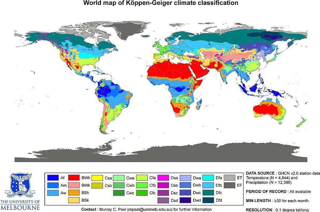
| Peel, M. C. and Finlayson, B. L. and McMahon, T. A. (2007). "Updated world map of the Köppen-Geiger climate classification". Hydrol. Earth Syst. Sci. 11: 1633-1644. ISSN 1027-5606. |
- This is the original JPG-file that is only uploaded as a reference. Please see/use the smaller PNG-file for thumbnailing etc...
概要
| 解説 | Updated world map of the Köppen-Geiger climate classification. |
| 日付 | |
| 原典 | Hydrology and Earth System Sciences: "Updated world map of the Köppen-Geiger climate classification" (Supplement). |
| 作者 |
Peel, M. C., Finlayson, B. L., and McMahon, T. A. (University of Melbourne) |
| 許可 (ファイルの再利用) |
See Image:World Köppen Map.png for an improved map to use on Wikipedia and such.
ライセンス
このファイルはクリエイティブ・コモンズ 表示-継承 2.5 一般ライセンスのもとに利用を許諾されています。
- あなたは以下の条件に従う場合に限り、自由に
- 共有 – 本作品を複製、頒布、展示、実演できます。
- 再構成 – 二次的著作物を作成できます。
- あなたの従うべき条件は以下の通りです。
- 表示 – あなたは適切なクレジットを表示し、ライセンスへのリンクを提供し、変更があったらその旨を示さなければなりません。これらは合理的であればどのような方法で行っても構いませんが、許諾者があなたやあなたの利用行為を支持していると示唆するような方法は除きます。
- 継承 – もしあなたがこの作品をリミックスしたり、改変したり、加工した場合には、あなたはあなたの貢献部分を元の作品とこれと同一または互換性があるライセンスの下に頒布しなければなりません。
ファイルの履歴
過去の版のファイルを表示するには、その版の日時をクリックしてください。
| 日付と時刻 | サムネイル | 寸法 | 利用者 | コメント | |
|---|---|---|---|---|---|
| 現在の版 | 2018年2月20日 (火) 16:55 | | 4,231 × 2,804 (1.25メガバイト) | Maphobbyist | The Caspian coastal lowland of Iran has a humid subtropical climate (Köppen classification: Cfa). The Costa Rican Central Valley has a dry winter oceanic climate (Köppen classification: Cwb). |
| 2011年4月4日 (月) 16:35 |  | 4,231 × 2,804 (808キロバイト) | Maphobbyist | Köppen system is based on the concept that climate types are correlated with the natural vegetation. Large bodies of water such as seas (in this case Caspian Sea) are excluded. | |
| 2011年4月1日 (金) 06:40 |  | 6,708 × 4,443 (4.73メガバイト) | Bidgee | Reverted to version as of 22:42, 12 October 2007 (Please don't override images) | |
| 2011年3月13日 (日) 12:09 |  | 4,231 × 2,804 (809キロバイト) | Maphobbyist | Slight improvement in image quality as is possible for jpg files. Painted the Caspian Sea as white, because the Köppen system is based on the concept that climate types are correlated with the natural vegetation. Thus with Köppen, climate zone boundarie | |
| 2007年10月12日 (金) 22:42 |  | 6,708 × 4,443 (4.73メガバイト) | Jeroen | Citation: '''Peel, M. C., Finlayson, B. L., and McMahon, T. A.: Updated world map of the Köppen-Geiger climate classification, Hydrol. Earth Syst. Sci., 11, 1633-1644, 2007.''' :This is the original JPG-file that is only uploaded as a reference. Please |
ファイルの使用状況
このファイルを使用しているページはありません。
グローバルなファイル使用状況
以下に挙げる他のウィキがこの画像を使っています:
- en.wikipedia.org での使用状況
- fa.wikipedia.org での使用状況
- he.wikipedia.org での使用状況
- pl.wikipedia.org での使用状況
- sco.wikipedia.org での使用状況
- vi.wikipedia.org での使用状況