
ファイル:Western Polynesia and Polynesian Outliers - fr.svg

元のファイル (SVG ファイル、1,238 × 939 ピクセル、ファイルサイズ: 4.02メガバイト)
ウィキメディア・コモンズのファイルページにある説明を、以下に表示します。
|
概要
| 解説 |
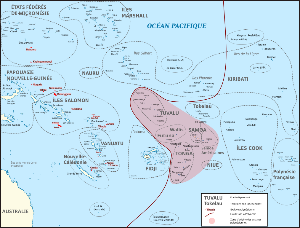
Français : Carte du Pacifique montrant la Polynésie occidentale et les différentes exclaves polynésiennes (en rouge). La zone en rouge clair correspond à la zone originelle de peuplement de Polynésie, d'où sont parties les populations qui habitent les exclaves polynésiennes. Les traits entourant les différents territoires ne sont pas les frontières maritimes actuelles, simplement un repère.
Carte d’origine : File:BLANK in Oceania (small islands magnified) (-mini map -rivers).svg Sources pour les noms des îles : Fidji : File:FijiOMCmap.png Nouvelle-Calédonie et Vanuatu :
Îles Salomon :
Tonga: FIle:Tonga.jpg Micronésie : File:Micronesia,_administrative_divisions_with_island_names_-_colored_-_fr.svg Îles Marshall: Kiribati :
Polynésie française : File:French_Polynesia_relief_map.svg Liste des exclaves polynésiennes : https://fr.wikipedia.org/wiki/Exclaves_polyn%C3%A9siennes
English: Map of Oceania showing Polynesian outliers. The red zone is the original Polynesian homeland, from where Polynesian seafarers went to the various Polynesian outliers. The lines around countries and territories are not the actual maritime borders.
Sources for this map : Original map : File:BLANK in Oceania (small islands magnified) (-mini map -rivers).svg Island names : Fidji : File:FijiOMCmap.png New Caledonia and Vanuatu
Solomon Islands :
Tonga: FIle:Tonga.jpg Micronesia: File:Micronesia,_administrative_divisions_with_island_names_-_colored_-_fr.svg Marshall islands: Kiribati :
French Polynesia : File:French_Polynesia_relief_map.svg List of Polynesian Outliers : https://fr.wikipedia.org/wiki/Exclaves_polyn%C3%A9siennes |
| 日付 | |
| 原典 | 投稿者自身による著作物 |
| 作者 | Skimel |
_(-mini_map_-rivers).svg)
.png)
ライセンス
- あなたは以下の条件に従う場合に限り、自由に
- 共有 – 本作品を複製、頒布、展示、実演できます。
- 再構成 – 二次的著作物を作成できます。
- あなたの従うべき条件は以下の通りです。
- 表示 – あなたは適切なクレジットを表示し、ライセンスへのリンクを提供し、変更があったらその旨を示さなければなりません。これらは合理的であればどのような方法で行っても構いませんが、許諾者があなたやあなたの利用行為を支持していると示唆するような方法は除きます。
- 継承 – もしあなたがこの作品をリミックスしたり、改変したり、加工した場合には、あなたはあなたの貢献部分を元の作品とこれと同一または互換性があるライセンスの下に頒布しなければなりません。
ファイルの履歴
過去の版のファイルを表示するには、その版の日時をクリックしてください。
| 日付と時刻 | サムネイル | 寸法 | 利用者 | コメント | |
|---|---|---|---|---|---|
| 現在の版 | 2016年11月12日 (土) 13:44 | | 1,238 × 939 (4.02メガバイト) | Skimel | Changed the fonts to DejaVu Sans condensed, resized the map, changed the shape of some country borders to fit the text better. |
| 2016年11月12日 (土) 11:50 |  | 2,476 × 1,885 (3.99メガバイト) | Skimel | Fixed the black box in the upper left corner, resized the map so that one can zoom in more (but apparently caused other black rectangles...) | |
| 2016年11月11日 (金) 13:22 |  | 617 × 466 (3.98メガバイト) | Skimel | User created page with UploadWizard |
ファイルの使用状況
以下のページがこのファイルを使用しています:
グローバルなファイル使用状況
以下に挙げる他のウィキがこの画像を使っています:
- ca.wikipedia.org での使用状況
- en.wikipedia.org での使用状況
- es.wikipedia.org での使用状況
- fr.wikipedia.org での使用状況
- it.wikipedia.org での使用状況
- ko.wikipedia.org での使用状況
- pt.wikipedia.org での使用状況