
ファイル:United Kingdom United States Locator.svg

この SVG ファイルのこの PNG プレビューのサイズ: 800 × 353 ピクセル. その他の解像度: 320 × 141 ピクセル | 640 × 283 ピクセル | 1,024 × 452 ピクセル | 1,280 × 565 ピクセル | 2,560 × 1,130 ピクセル | 940 × 415 ピクセル。
元のファイル (SVG ファイル、940 × 415 ピクセル、ファイルサイズ: 2.56メガバイト)
ウィキメディア・コモンズのファイルページにある説明を、以下に表示します。
|
概要
| 解説 |
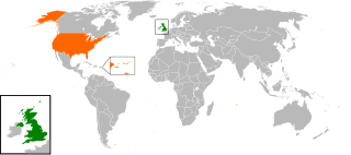
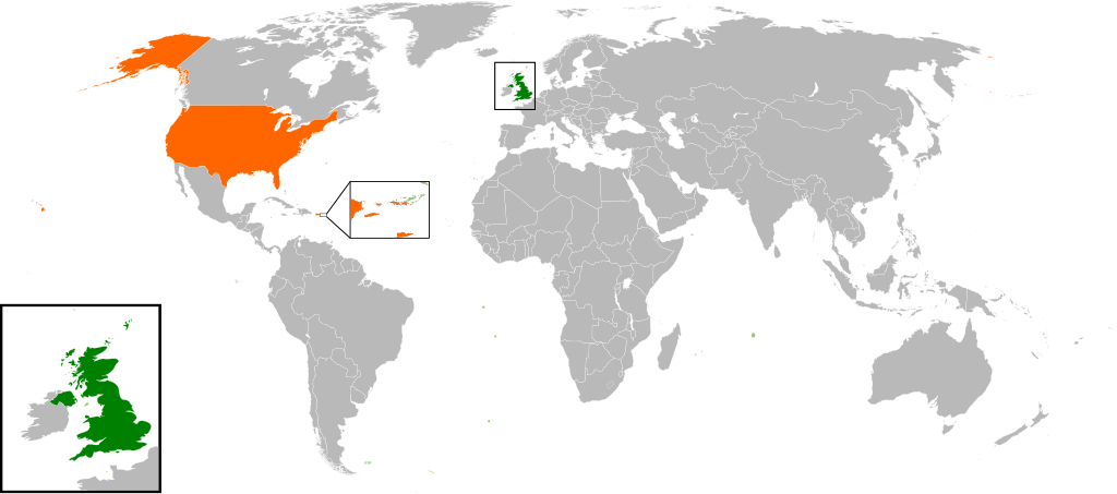
English: Map of the world showing the location of the United Kingdom and the United States of America. |
| 日付 | |
| 原典 | 投稿者自身による著作物 |
| 作者 | Jolly Janner |
ライセンス
| この著作物の著作権者である私は、この著作物における権利を放棄しパブリックドメインとします。これは全世界で適用されます。 一部の国では、これが法的に可能ではない場合があります。その場合は、次のように宣言します。 私は、あらゆる人に対して、法により必要とされている条件を除き、如何なる条件も課すことなく、あらゆる目的のためにこの著作物を使用する権利を与えます。 |
ファイルの履歴
過去の版のファイルを表示するには、その版の日時をクリックしてください。
| 日付と時刻 | サムネイル | 寸法 | 利用者 | コメント | |
|---|---|---|---|---|---|
| 現在の版 | 2017年3月20日 (月) 16:00 | | 940 × 415 (2.56メガバイト) | RaviC | add dependencies, inset map for Virgin Islands region where both states share a maritime border |
| 2016年12月24日 (土) 02:43 |  | 940 × 415 (1.79メガバイト) | BurritoBazooka | put all Faroe islands except Suðuroy region behind black border of UK box. Make two boxes (transparent group rectangle and white bg rectangle) same stroke thickness. | |
| 2016年12月24日 (土) 00:43 |  | 940 × 415 (1.79メガバイト) | BurritoBazooka | add France and Faroe Islands to UK box by re-cutting it from its place on the map (b/c why should ROI, another sovereign state, be shown, and not France and the Faroe Islands?) Also the box has its own group now. | |
| 2016年12月24日 (土) 00:34 |  | 940 × 415 (1.78メガバイト) | BurritoBazooka | French Polynesia, Pitcairn Islands were showing in the UK box, but these are not in the same area as the British Isles at all. Also, are Falklands etc not on the same level as Puerto Rico? | |
| 2016年12月7日 (水) 18:38 |  | 940 × 415 (1.78メガバイト) | Mikey641 | Accident | |
| 2016年12月7日 (水) 18:38 |  | 512 × 226 (753キロバイト) | Mikey641 | -- | |
| 2013年3月3日 (日) 18:09 |  | 940 × 415 (1.78メガバイト) | Timothy Gu | +South Sudan (w/ small Britain map) | |
| 2012年3月2日 (金) 21:25 |  | 940 × 415 (1.63メガバイト) | Jrobin08 | Reverted to version as of 20:37, 24 June 2009 (Easier to see the United Kingdom. Maybe someone can add South Sudan to the map, but keep the UK zoom box in.) | |
| 2011年9月23日 (金) 21:05 |  | 940 × 415 (1.76メガバイト) | Bazonka2 | + South Sudan | |
| 2009年6月24日 (水) 20:37 |  | 940 × 415 (1.63メガバイト) | Jolly Janner | {{Information |Description={{en|1=Map of the world showing the location of the United Kingdom and the United States of America.}} |Source=Own work by uploader |Author=Jolly Janner |Date=2009-0 |
ファイルの使用状況
以下のページがこのファイルを使用しています:
グローバルなファイル使用状況
以下に挙げる他のウィキがこの画像を使っています:
- ar.wikipedia.org での使用状況
- ca.wikipedia.org での使用状況
- de.wikipedia.org での使用状況
- en.wikipedia.org での使用状況
- es.wikipedia.org での使用状況
- fr.wikipedia.org での使用状況
- he.wikipedia.org での使用状況
- hy.wikipedia.org での使用状況
- id.wikipedia.org での使用状況
- it.wikipedia.org での使用状況
- ps.wikipedia.org での使用状況
- pt.wikipedia.org での使用状況
- ru.wikipedia.org での使用状況
- th.wikipedia.org での使用状況
- tr.wikipedia.org での使用状況
- uk.wikipedia.org での使用状況
- www.wikidata.org での使用状況
- zh.wikipedia.org での使用状況