
ファイル:Significant tornado alley.gif
高解像度版はありません。
Significant_tornado_alley.gif (512 × 360 ピクセル、ファイルサイズ: 8キロバイト、MIME タイプ: image/gif)
ウィキメディア・コモンズのファイルページにある説明を、以下に表示します。
|
概要
| 解説 |
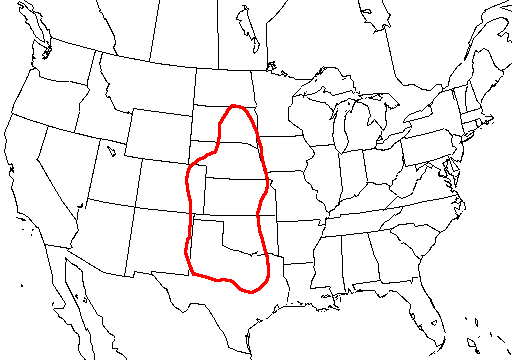
English: A map of the united states with Tornado Alley outlined, here defined as the area where approximately 1 day or greater per decade was near (25 mi; 40 km) a significant (F2 or stronger) tornado. |
| 原典 | http://www.nssl.noaa.gov/hazard/svrwxmisc.html http://www.nssl.noaa.gov/hazard/img/sigtoralley.gif |
| 作者 | NSSL |
ライセンス
|
|
- The NOAA emblem is the property of the U.S. Government and a trademark of the United States Department of Commerce.
ファイルの履歴
過去の版のファイルを表示するには、その版の日時をクリックしてください。
| 日付と時刻 | サムネイル | 寸法 | 利用者 | コメント | |
|---|---|---|---|---|---|
| 現在の版 | 2006年10月20日 (金) 07:23 | | 512 × 360 (8キロバイト) | Runningonbrains | {{Information |Description=A map of the united states with Tornado Alley outlined, here defined as the area where approximately 1 day or greater per decade contained a significant tornado. |Source=http://www.nssl.noaa.gov |
ファイルの使用状況
このファイルを使用しているページはありません。
グローバルなファイル使用状況
以下に挙げる他のウィキがこの画像を使っています:
- de.wikipedia.org での使用状況
- en.wikipedia.org での使用状況
- fi.wikipedia.org での使用状況
- fr.wikipedia.org での使用状況
- gl.wikipedia.org での使用状況
- it.wikipedia.org での使用状況
- lt.wikipedia.org での使用状況
- pt.wikipedia.org での使用状況
- ru.wikipedia.org での使用状況
- simple.wikipedia.org での使用状況
- uk.wikipedia.org での使用状況