
ファイル:Sea-of-Okhotsk-Full-Map-Hokkaido-Kuril-Kamchatka-Sakhalin.png

このプレビューのサイズ: 800 × 547 ピクセル。 その他の解像度: 320 × 219 ピクセル | 640 × 438 ピクセル | 1,024 × 700 ピクセル | 1,280 × 875 ピクセル | 2,560 × 1,751 ピクセル | 5,188 × 3,548 ピクセル。
元のファイル (5,188 × 3,548 ピクセル、ファイルサイズ: 14.83メガバイト、MIME タイプ: image/png)
ウィキメディア・コモンズのファイルページにある説明を、以下に表示します。
|
概要
| 解説 |
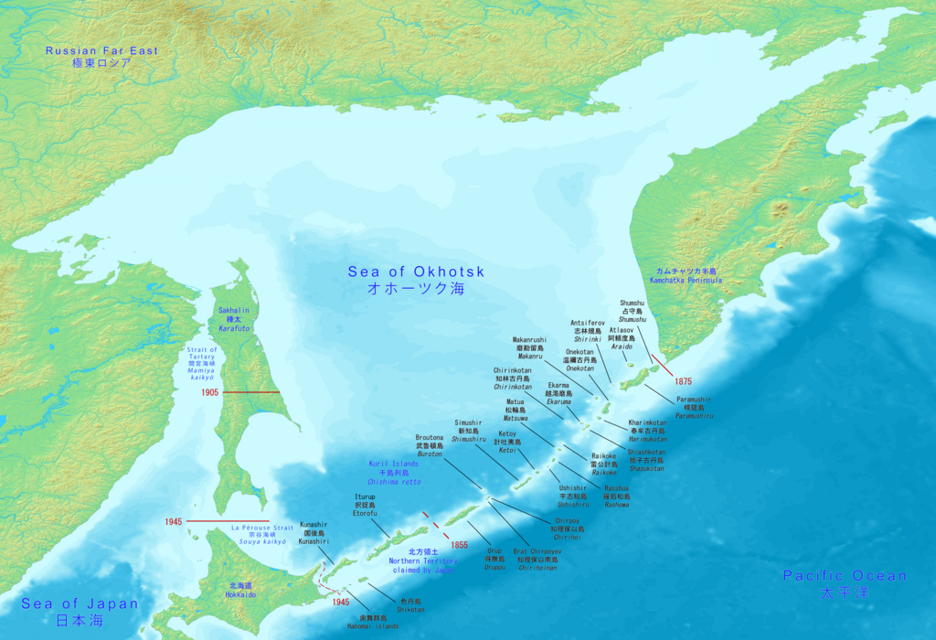
English: Big map has the full Sea of Okhotsk with Hokkaido, Kuril islands, Kamchatka peninsula and Sakhalin (Karafuto). It includes the Japanese and Russian names with English.
日本語: 大きな地図には、北海道、千島列島、カムチャッカ半島、サハリン(樺太)を含むオホーツク海全体が表示されます。 日本語とロシア語の名前と英語が含まれています。
Русский: Большая карта имеет полное Охотское море с Хоккайдо, Курильскими островами, полуостровом Камчатка и Сахалином (Карафуто). В него входят японские и русские названия с английскими. |
| 日付 | |
| 原典 | Made with DEMIS World Map Server https://www.demis.nl/products/web-map-server/examples |
| 作者 | DEMIS World Map Server, Artanisen |
| その他のバージョン |
|

ライセンス
| このファイルはクリエイティブ・コモンズ CC0 1.0 全世界 パブリック・ドメイン提供のもとで利用可能にされています。 | |
| ある作品に本コモンズ証を関連づけた者は、その作品について世界全地域において著作権法上認められる、その者が持つすべての権利(その作品に関する権利や隣接する権利を含む。)を、法令上認められる最大限の範囲で放棄して、パブリック・ドメインに提供しています。
この作品は、たとえ営利目的であっても、許可を得ずに複製、改変・翻案、配布、上演・演奏することが出来ます。 |
ファイルの履歴
過去の版のファイルを表示するには、その版の日時をクリックしてください。
| 日付と時刻 | サムネイル | 寸法 | 利用者 | コメント | |
|---|---|---|---|---|---|
| 現在の版 | 2020年6月17日 (水) 15:10 | | 5,188 × 3,548 (14.83メガバイト) | Artanisen | Corrected Japanese spelling: オホーツク海 |
| 2020年6月17日 (水) 00:37 |  | 5,188 × 3,548 (14.83メガバイト) | Artanisen | Fixed letter font of Shumshu. | |
| 2020年6月16日 (火) 16:44 |  | 5,188 × 3,548 (14.83メガバイト) | Artanisen | Updated to show the full Sea of Okhotsk with a big detailed map. It includes the Japanese and Russian names with standard English translations. | |
| 2020年6月13日 (土) 21:00 |  | 3,280 × 2,144 (2.24メガバイト) | Artanisen | Uploaded a work by DEMIS World Map Server, Artanisen from https://www.demis.nl/products/web-map-server/examples with UploadWizard |
ファイルの使用状況
このファイルを使用しているページはありません。
グローバルなファイル使用状況
以下に挙げる他のウィキがこの画像を使っています:
- ca.wikipedia.org での使用状況
- en.wikipedia.org での使用状況
- ky.wikipedia.org での使用状況
- sl.wikipedia.org での使用状況
- sr.wikipedia.org での使用状況