ファイル:Royce-areas-michigan.jpg

ページのコンテンツが他言語でサポートされていません。

元のファイル(1,495 × 1,740 ピクセル、ファイルサイズ: 511キロバイト、MIME タイプ: image/jpeg)

概要

解説
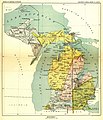
English: This 19th century map, produced by the Smithsonian Institution, depicts the major Native American land cessions that resulted in what is now Michigan.
  • United States Serial Set Number 4015 contains the second part of the two-part Eighteenth Annual Report of the Bureau of American Ethnology to the Secretary of the Smithsonian Institution, 1896-1897. Indian Land Cessions in the United States, 1784-1894 United States Serial Set, Number 4015
Français : Carte du 19ème siècle montrant les cessions de territoire des Amérindiens au gouvernement américain dans la région où se trouve aujourd'hui l'état du Michigan. Le territoire en jaune sur la carte a ainsi été cédé aux USA en 1836 lors du traité de Washington.
日付 1896年と1897年の間
date QS:P,+1896-00-00T00:00:00Z/8,P1319,+1896-00-00T00:00:00Z/9,P1326,+1897-00-00T00:00:00Z/9
原典 United States Serial Set Number 4015 contains the second part of the two-part Eighteenth Annual Report of the Bureau of American Ethnology to the Secretary of the Smithsonian Institution, 1896-1897. Indian Land Cessions in the United States, 1784-1894 United States Serial Set, Number 4015
作者 Bureau of American Ethnology

ライセンス

Public domain
Public domain
このファイルはアメリカ合衆国においてパブリックドメインの状態にあります。これは多くの場合、最初の公表が1929年1月1日以前であるために著作権が消滅したアメリカ合衆国の著作物に適用されます。より詳細な説明については、このページをご覧ください。

United States
United States
このファイルはアメリカ合衆国以外ではパブリックドメインの状態にはない可能性があり、この点は、特に、カナダ、中華人民共和国(香港・マカオを除く)、ドイツ、メキシコ及びスイスのようにアメリカ合衆国の著作物の著作権の保護期間について相互主義を採用していない国・地域で当てはまります。作者や公表年は必要な情報であり、条件とされるべきものです。詳細についてはWikipedia:Public domain及びWikipedia:Copyrightsをご覧ください。

元のアップロードログ

元のファイルページはこちら。以下の利用者は全てen.wikipediaに属します。
  • 2004-09-29 23:56 Jengod 1495×1740× (522824 bytes) {{PD}} source info in a sec

キャプション

このファイルの内容を1行で記述してください

このファイルに描写されている項目

題材

ファイルの履歴

過去の版のファイルを表示するには、その版の日時をクリックしてください。

日付と時刻サムネイル寸法利用者コメント
現在の版2009年5月11日 (月) 15:132009年5月11日 (月) 15:13時点における版のサムネイル1,495 × 1,740 (511キロバイト)Sylfred1977{{Information |Description={{en|This 19th century map, produced by the Smithsonian Institution, depicts the major Native American land cessions that resulted in what is now Michigan. United States Serial Set Number 4015 contains the second part of the two

以下のページがこのファイルを使用しています:

グローバルなファイル使用状況

以下に挙げる他のウィキがこの画像を使っています:

メタデータ