
ファイル:RogersCrkNorthHayward.gif
高解像度版はありません。
RogersCrkNorthHayward.gif (640 × 440 ピクセル、ファイルサイズ: 23キロバイト、MIME タイプ: image/gif)
ウィキメディア・コモンズのファイルページにある説明を、以下に表示します。
|
| 解説 |
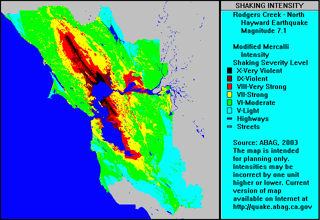
English: ABAG shake map for Rodgers Creek Fault Zone and north Hayward Fault Zone (single event) with colors representing ground motion in the Mercalli Intensity Scale. Note that colors used in the Mercalli article do not correspond to colors used in the ABAG map shown here — use Roman numerals for cross reference. |
| 日付 | 2004年9月5日 (当初のアップロード日) |
| 原典 | en.wikipedia からコモンズに移動されました。 |
| 作者 | オリジナルのアップロード者は英語版ウィキペディアのLeonard G.さん |
ライセンス
この作品は、次の理由で'パブリックドメインに属します。it is a work by or prepared for a tax-supported government agency, the Association of Bay Area Governments (ABAG).
From the ABAG web page [1]:
パブリックドメインの適用が法的に不可能な場合: 誰でも、いかなる目的であっても、法令によって要求される条件以外のいかなる条件も課されることなしに、この作品を利用する権利が認められます。 上記で説明されている理由が、コモンズのライセンス方針に準拠しているかどうか検証してください。
|
元のアップロードログ
元のファイルページはこちら。以下の利用者は全てen.wikipediaに属します。
- 2004-09-05 03:57 Leonard G. 640×440× (23379 bytes) ABAG shake map for Rodgers Creek and North Hayward - public domain image
ファイルの履歴
過去の版のファイルを表示するには、その版の日時をクリックしてください。
| 日付と時刻 | サムネイル | 寸法 | 利用者 | コメント | |
|---|---|---|---|---|---|
| 現在の版 | 2009年5月1日 (金) 07:47 | | 640 × 440 (23キロバイト) | Carlog3 | {{Information |Description={{en|en:ABAG shake map for en:Rodgers Creek Fault Zone and north en:Hayward Fault Zone (single event) with colors representing ground motion in the en:Mercalli Intensity Scale. Note that colors used in th |
ファイルの使用状況
以下のページがこのファイルを使用しています:
グローバルなファイル使用状況
以下に挙げる他のウィキがこの画像を使っています:
- de.wikipedia.org での使用状況
- en.wikipedia.org での使用状況
- en.wikibooks.org での使用状況
- en.wiktionary.org での使用状況
- fa.wikipedia.org での使用状況
- it.wikipedia.org での使用状況
- it.wikibooks.org での使用状況
- it.wikiversity.org での使用状況