
ファイル:Pusan Perimeter.jpg
高解像度版はありません。
Pusan_Perimeter.jpg (350 × 572 ピクセル、ファイルサイズ: 52キロバイト、MIME タイプ: image/jpeg)
ウィキメディア・コモンズのファイルページにある説明を、以下に表示します。
|
概要
| 解説 |
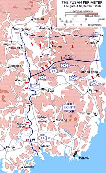
English: Map of the Pusan Perimeter, August 1950. |
| 原典 | This map was created by the Center for Military History and used in the brochure "The Korean War: The Outbreak" located at [1]. |
| 作者 | United States Army Center of Military History |
| その他のバージョン |
|
.jpg)
.jpg)
.jpg)
.jpg)
.jpg)
ライセンス
| This image is in the public domain because it contains materials that originally came from the United States Army Center of Military History, subject to the following qualification.
Note: The images of all badges, insignia, decorations and medals on the "CMH Online" web site are produced by the United States Army Institute of Heraldry and protected by Title 18, United States Code, Section 704 and the Code of Federal Regulations (32 CFR, Part 507). Permission to use these images for commercial purposes must be obtained from The Institute of Heraldry prior to their use. |

|
元のアップロードログ
元のファイルページはこちら。以下の利用者は全てen.wikipediaに属します。
ファイルの履歴
過去の版のファイルを表示するには、その版の日時をクリックしてください。
| 日付と時刻 | サムネイル | 寸法 | 利用者 | コメント | |
|---|---|---|---|---|---|
| 現在の版 | 2008年3月15日 (土) 01:13 | | 350 × 572 (52キロバイト) | Donostiarra~commonswiki | {{Information |Description={{en|Map of the Pusan Perimeter, August 1950. This map was created by the Center for Military History and used in the brochure "The Korean War: The Outbreak" located at [http://www.army.mil/cmh-pg/brochures/KW-Outbreak/outbreak. |
ファイルの使用状況
このファイルを使用しているページはありません。
グローバルなファイル使用状況
以下に挙げる他のウィキがこの画像を使っています:
- ar.wikipedia.org での使用状況
- cs.wikipedia.org での使用状況
- de.wikipedia.org での使用状況
- en.wikipedia.org での使用状況
- es.wikipedia.org での使用状況
- fr.wikipedia.org での使用状況
- he.wikipedia.org での使用状況
- ko.wikipedia.org での使用状況
- no.wikipedia.org での使用状況
- pl.wikipedia.org での使用状況
- pt.wikipedia.org での使用状況
- ru.wikipedia.org での使用状況
- simple.wikipedia.org での使用状況
- uk.wikipedia.org での使用状況
- vi.wikipedia.org での使用状況