
ファイル:Puertoprincesa chart4343 1904.jpeg
このプレビューのサイズ: 715 × 600 ピクセル。 その他の解像度: 286 × 240 ピクセル | 572 × 480 ピクセル | 916 × 768 ピクセル | 1,221 × 1,024 ピクセル | 2,442 × 2,048 ピクセル | 3,053 × 2,561 ピクセル。
元のファイル (3,053 × 2,561 ピクセル、ファイルサイズ: 1.31メガバイト、MIME タイプ: image/jpeg)
ウィキメディア・コモンズのファイルページにある説明を、以下に表示します。
|
| 解説 |
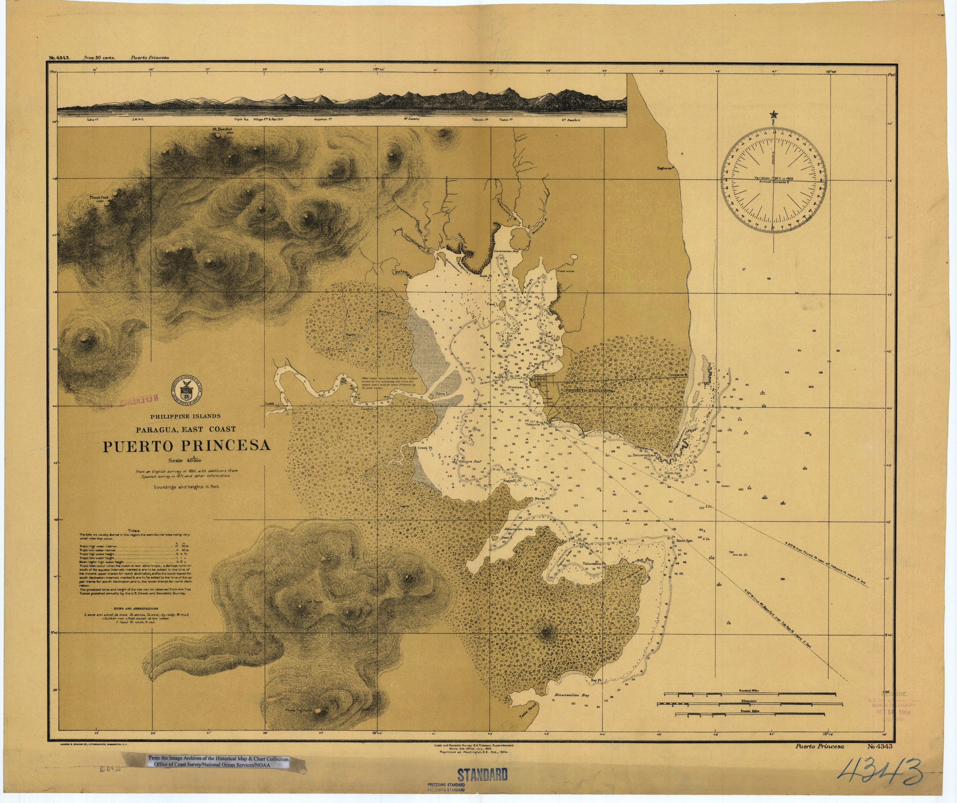
English: Scanned image of US Coast & Geodetic Survey (Manila Office) nautical chart #4343 Puerto Princesa, (Paragua), Palawan, Philippines. |
|||
| 日付 | ||||
| 原典 |
English: From the image archives of the Historical Map & Chart Collection/Office of Coast Survey/National Ocean Service/NOAA/United States government. Converted from MrSID to JPEG format for upload to Commons. |
|||
| 作者 | Coast and Geodetic Survey O.H. Tittmann, Superintendent. Manila Sub-Office. July 1903 | |||
| 許可 (ファイルの再利用) |
|
ファイルの履歴
過去の版のファイルを表示するには、その版の日時をクリックしてください。
| 日付と時刻 | サムネイル | 寸法 | 利用者 | コメント | |
|---|---|---|---|---|---|
| 現在の版 | 2006年3月17日 (金) 01:41 | | 3,053 × 2,561 (1.31メガバイト) | Cdc~commonswiki | Scanned image of US Coast & Geodetic Survey (Manila Office) nautical chart #4343 Puerto Princesa, (Paragua), Palawan, Philippines, 1904. From the Image Archives of the [http://chartmaker.ncd.noaa.gov/csdl/ctp/abstract.htm Historical Map & Chart Collecti |
ファイルの使用状況
以下のページがこのファイルを使用しています:
グローバルなファイル使用状況
以下に挙げる他のウィキがこの画像を使っています:
- en.wikipedia.org での使用状況
- es.wikipedia.org での使用状況
- ka.wikipedia.org での使用状況
- ko.wikipedia.org での使用状況
- pam.wikipedia.org での使用状況
- pt.wikipedia.org での使用状況
- tl.wikipedia.org での使用状況