
ファイル:Porter1796WesternReserve-300.jpg

このプレビューのサイズ: 800 × 534 ピクセル。 その他の解像度: 320 × 213 ピクセル | 640 × 427 ピクセル | 1,024 × 683 ピクセル | 1,280 × 854 ピクセル | 2,560 × 1,707 ピクセル | 7,403 × 4,937 ピクセル。
元のファイル (7,403 × 4,937 ピクセル、ファイルサイズ: 6.67メガバイト、MIME タイプ: image/jpeg)
ウィキメディア・コモンズのファイルページにある説明を、以下に表示します。
|
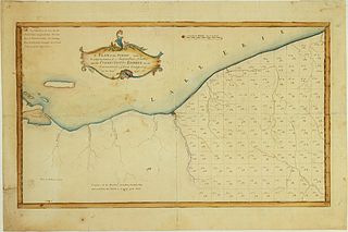
| 解説 | A Plan of the Survey made by & under the direction of Augustus Porter upon the Connecticut-Reserve for the Connecticut Land Company in the Year 1796. Showing the Western Reserve divided into sections and the town and city of Cleaveland (Cleveland) |
| 日付 | |
| 原典 | William L. Clements Library (University of Michigan) |
| 作者 | Augustus Porter |
| その他のバージョン | http://www.railsandtrails.com/Maps/Porter1796WesternReserve/index.htm |
|
この著作物は、著作権の保護期間が著作者の死後100年以下である国・地域においてパブリックドメインの状態にあります。 | |
| このファイルは著作権法の既知の制約(隣接権や関連する権利を含む)から自由であると特定されています。 | |
ファイルの履歴
過去の版のファイルを表示するには、その版の日時をクリックしてください。
| 日付と時刻 | サムネイル | 寸法 | 利用者 | コメント | |
|---|---|---|---|---|---|
| 現在の版 | 2010年10月13日 (水) 23:43 | | 7,403 × 4,937 (6.67メガバイト) | Scewing | {{Information |Description=A Plan of the Survey made by & under the direction of Augustus Porter upon the Connecticut-Reserve for the Connecticut Land Company in the Year 1796. Showing the Western Reserve divided into sections and the town and city of Cle |
ファイルの使用状況
以下のページがこのファイルを使用しています:
グローバルなファイル使用状況
以下に挙げる他のウィキがこの画像を使っています:
- en.wikipedia.org での使用状況
- zh.wikipedia.org での使用状況