
ファイル:Ph locator map la union.png
高解像度版はありません。
Ph_locator_map_la_union.png (300 × 440 ピクセル、ファイルサイズ: 19キロバイト、MIME タイプ: image/png)
ウィキメディア・コモンズのファイルページにある説明を、以下に表示します。
|
概要
| 解説 |
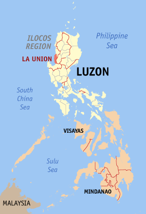
English: Map of the Philippines showing the location of La Union |
| 日付 | |
| 原典 | English Wikipedia |
| 作者 | Eugene Alvin Villar (seav) |
ライセンス

|
この文書は、フリーソフトウェア財団発行のGNUフリー文書利用許諾書 (GNU Free Documentation License) 1.2またはそれ以降のバージョンの規約に基づき、複製や再配布、改変が許可されます。不可変更部分、表紙、背表紙はありません。このライセンスの複製は、GNUフリー文書利用許諾書という章に含まれています。 |
| このファイルはクリエイティブ・コモンズ 表示-継承 3.0 非移植ライセンスのもとに利用を許諾されています。 | ||
| ||
| このライセンスのテンプレートは、GFDLのライセンス・アップデートによりこのファイルに追加されたものです。 |

|
If you choose to use this work under the Creative Commons license stated on this page, the author, Eugene Alvin Villar (seav), would like you to attribute the work to him (among other requirements such as indicating that the work is licensed under the Creative Commons) with the following text or similar:
© Eugene Alvin Villar, 2003
His name should be a link to his Wikimedia Commons userpage. If a link is not possible, then the url should be placed in parentheses after the name. If the work has been substantially altered by other people (see the File history section below), then this particular attribution requirement is waived, which means you can attribute the work in any reasonable manner. This attribution requirement is provided pursuant to the Creative Commons Attribution mechanism where "you must attribute the work in the manner specified by the author or licensor (but not in any way that suggests that they endorse you or your use of the work)." (See "Attribution" in the Creative Commons website.)
|
ファイルの履歴
過去の版のファイルを表示するには、その版の日時をクリックしてください。
| 日付と時刻 | サムネイル | 寸法 | 利用者 | コメント | |
|---|---|---|---|---|---|
| 現在の版 | 2005年12月30日 (金) 14:02 | | 300 × 440 (19キロバイト) | Magalhães | |
| 2005年8月14日 (日) 06:39 |  | 300 × 450 (15キロバイト) | Magalhães | Map of the Philippines showing the location of La Union. Source: [http://en.wikipedia.org/wiki/Image:Ph_locator_map_la_union.png English wikipedia] {{GFDL}} Category: Maps of the Philippines |
ファイルの使用状況
このファイルを使用しているページはありません。