
ファイル:Ossetia rus.png

このプレビューのサイズ: 391 × 599 ピクセル。 その他の解像度: 156 × 240 ピクセル | 313 × 480 ピクセル | 696 × 1,067 ピクセル。
元のファイル (696 × 1,067 ピクセル、ファイルサイズ: 50キロバイト、MIME タイプ: image/png)
ウィキメディア・コモンズのファイルページにある説明を、以下に表示します。
|
概要
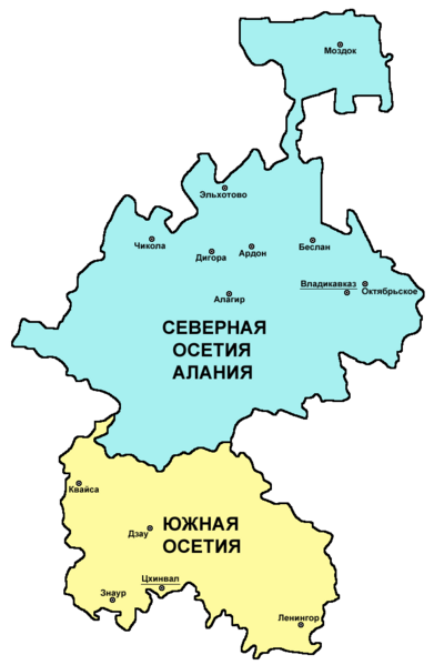
| 解説 | Map of Ossetia (North Ossetia and South Ossetia) - Russian language version. |
| 日付 | 2007年12月28日 (当初のアップロード日) |
| 原典 | 投稿者自身による著作物 |
| 作者 | PANONIAN and Chesnok |
ライセンス
self made map - Russian language version of this file: http://commons.wikimedia.org/wiki/File:Ossetia01.png (author of that file is User:PANONIAN).
| この著作物の著作権者である私は、この著作物における権利を放棄しパブリックドメインとします。これは全世界で適用されます。 一部の国では、これが法的に可能ではない場合があります。その場合は、次のように宣言します。 私は、あらゆる人に対して、法により必要とされている条件を除き、如何なる条件も課すことなく、あらゆる目的のためにこの著作物を使用する権利を与えます。 |

|
This map has been uploaded by Electionworld from en.wikipedia.org to enable the |
References
Borders and locations of major settlements:
- http://iratta.com/uploads/posts/atlas/21/karta.jpg
- http://foto.mail.ru/bk/lyks2003/150/163.html
- http://4.bp.blogspot.com/_PB5-El7se4s/SJzcr3lGyAI/AAAAAAAAISU/kagljy4-1b0/s400/ossetia+map.jpg
- http://static.guim.co.uk/sys-images/Guardian/Pix/pictures/2008/8/8/1218195196317/ossetia220.jpg
- http://www.pri.org/theworld/files/images/ossetia_map.jpg
List of larger settlements:
ファイルの履歴
過去の版のファイルを表示するには、その版の日時をクリックしてください。
| 日付と時刻 | サムネイル | 寸法 | 利用者 | コメント | |
|---|---|---|---|---|---|
| 現在の版 | 2011年3月6日 (日) 10:24 | | 696 × 1,067 (50キロバイト) | PANONIAN | improved version |
| 2007年12月28日 (金) 07:16 |  | 453 × 674 (8キロバイト) | Chesnok | {{ew|en|PANONIAN}} map of Ossetia (self made) {{PD-self}} Category:Ossetia Category:Maps of the Russian republics Category:Maps of Georgia |
ファイルの使用状況
以下のページがこのファイルを使用しています:
グローバルなファイル使用状況
以下に挙げる他のウィキがこの画像を使っています:
- krc.wikipedia.org での使用状況
- ru.wikipedia.org での使用状況
- sk.wikipedia.org での使用状況
- uk.wikipedia.org での使用状況
- zh.wikipedia.org での使用状況