
ファイル:Orient-Express 1919-1921-2.png

このプレビューのサイズ: 800 × 570 ピクセル。 その他の解像度: 320 × 228 ピクセル | 640 × 456 ピクセル | 1,024 × 730 ピクセル | 1,280 × 912 ピクセル | 2,284 × 1,628 ピクセル。
元のファイル (2,284 × 1,628 ピクセル、ファイルサイズ: 762キロバイト、MIME タイプ: image/png)
ウィキメディア・コモンズのファイルページにある説明を、以下に表示します。
|
概要
| 解説 |
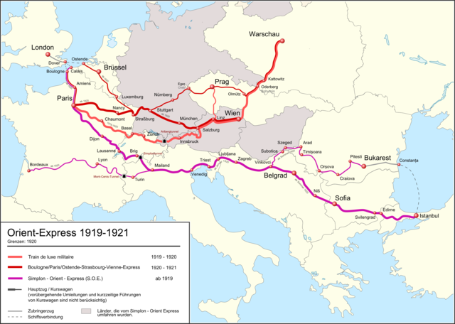
Deutsch: Karte der Orient Express Züge von 1919 bis 1921. Landesgrenzen von 1920.
English: Route of the Orient Express Trains from 1919 to 1921. National borders as per 1920
Français : Carte des trajets de l'Orient Express de 1919 à 1921. Frontier de 1920. |
| 日付 | 2012年2月29日 01:46 (UTC) |
| 原典 |
このファイルの派生元: |
| 作者 |
|
| その他のバージョン |
|


ライセンス
このファイルはクリエイティブ・コモンズ 表示-継承 3.0 非移植ライセンスのもとに利用を許諾されています。
- あなたは以下の条件に従う場合に限り、自由に
- 共有 – 本作品を複製、頒布、展示、実演できます。
- 再構成 – 二次的著作物を作成できます。
- あなたの従うべき条件は以下の通りです。
- 表示 – あなたは適切なクレジットを表示し、ライセンスへのリンクを提供し、変更があったらその旨を示さなければなりません。これらは合理的であればどのような方法で行っても構いませんが、許諾者があなたやあなたの利用行為を支持していると示唆するような方法は除きます。
- 継承 – もしあなたがこの作品をリミックスしたり、改変したり、加工した場合には、あなたはあなたの貢献部分を元の作品とこれと同一または互換性があるライセンスの下に頒布しなければなりません。
元のアップロードログ
This image is a derivative work of the following images:
- File:Blank_map_of_Europe_in_1920.svg licensed with Cc-by-sa-3.0
- 2010-08-20T04:42:56Z Editor at Large 841x732 (553816 Bytes) Reverted to version as of 16:11, 23 June 2008 - error in file
- 2010-08-20T01:30:27Z Maps & Lucy 689x600 (2132 Bytes) Fixed serious error with Baltic Sea on the German border with it, fixed the border of Germany with Poland, fixed the border of Poland with the Russian SFSR, and corrected the assimulation of three southern Caucasus countries
- 2008-06-23T16:11:09Z Themightyquill 841x732 (553816 Bytes)
- 2008-06-16T15:46:25Z Themightyquill 841x732 (546594 Bytes)
- 2008-06-16T15:27:00Z Themightyquill 841x732 (543357 Bytes)
- 2008-06-16T02:32:20Z Themightyquill 841x732 (574986 Bytes) {{Information |Description={{fr|Carte vierge de l'Europe en 1920, couleurs Atelier Graphique}} {{en|Blank map of Europe in 1920 with Atelier graphique colors}} |Source=*[[:Image:Blank_map_of_Europe_-_Atelier_graphique_colors.
- File:Orient-Express_1921-1939-2.png licensed with Cc-by-sa-3.0
- 2012-02-26T20:24:44Z Pechristener 2284x1624 (1000410 Bytes) fehlende Städtenamen ergänzt / Bemerkung in der Legende / Grösse der Städtenamen
- 2012-02-26T14:56:56Z Pechristener 2285x1626 (970795 Bytes) finale Version noch nicht von [[de:User:Wahldresdner]] kontrolliert
- 2012-02-25T00:16:59Z Pechristener 2285x1626 (924048 Bytes) == {{int:filedesc}} == {{Information |Description={{en}}Route of the Orient Express Trains from 1921 to 1939. National borders as per 1929-1938 (not yet finisched) {{de}}Karte des Orient Express Züge von 1921 bis 1939. Lande
ファイルの履歴
過去の版のファイルを表示するには、その版の日時をクリックしてください。
| 日付と時刻 | サムネイル | 寸法 | 利用者 | コメント | |
|---|---|---|---|---|---|
| 現在の版 | 2018年1月3日 (水) 07:32 | | 2,284 × 1,628 (762キロバイト) | Pechristener | korr Constanţa |
| 2012年3月10日 (土) 01:42 |  | 2,284 × 1,628 (762キロバイト) | Pechristener | some water bodies got lost, fixed | |
| 2012年3月7日 (水) 02:27 |  | 2,284 × 1,628 (740キロバイト) | Pechristener | Kurswagen aus Amsterdam entfernt / Lesbarkeit Schrift | |
| 2012年3月1日 (木) 01:45 |  | 2,284 × 1,628 (747キロバイト) | Pechristener | diverse Ergänzungen / richtig Stellungen gemäss Kartenwerkstatt de:User:Wahldresdner | |
| 2012年2月29日 (水) 01:55 |  | 2,284 × 1,628 (727キロバイト) | Pechristener | == {{int:filedesc}} == {{Information |Description={{de}}Karte der Orient Express Züge von 1919 bis 1921. Landesgrenzen von 1920. {{fr}}Carte des trajets de l'Orient Express de 1919 à 1921. Frontier de 1920. {{en}}Route of the Orient Express Trains fr... |
ファイルの使用状況
以下のページがこのファイルを使用しています:
グローバルなファイル使用状況
以下に挙げる他のウィキがこの画像を使っています:
- de.wikipedia.org での使用状況
- fr.wikipedia.org での使用状況
- nl.wikipedia.org での使用状況
- pt.wikipedia.org での使用状況
- www.wikidata.org での使用状況