
ファイル:NorthAmerica-WaterDivides.png

このプレビューのサイズ: 600 × 600 ピクセル。 その他の解像度: 240 × 240 ピクセル | 480 × 480 ピクセル | 900 × 900 ピクセル。
元のファイル (900 × 900 ピクセル、ファイルサイズ: 370キロバイト、MIME タイプ: image/png)
ウィキメディア・コモンズのファイルページにある説明を、以下に表示します。
|
概要
| 解説 |
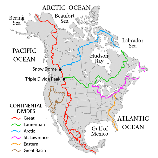
English: Map showing the major Continental divides of North America, following the style of File:NorthAmericaDivides.gif and intended as a replacement. Made using File:BlankMap-North America-Subdivisions.svg as a base map. Various maps and other sources consulted, such as: File:Ocean drainage.png, Drainage Basins, The Atlas of Canada, http://www.cec.org/atlas/files/watersheds/na_watersheds_en.jpg, and others. Note: the Eastern watershed boundary in the southern areas (orange line), and the St. Lawrence watershed boundary in the northern areas (magenta line) of this map more or less defined the Royal Proclamation's western boundaries. |
| 日付 | |
| 原典 | 投稿者自身による著作物 |
| 作者 | Pfly |
ライセンス
この作品の著作権者である私は、この作品を以下のライセンスで提供します。
このファイルはクリエイティブ・コモンズ 表示-継承 3.0 非移植ライセンスのもとに利用を許諾されています。
- あなたは以下の条件に従う場合に限り、自由に
- 共有 – 本作品を複製、頒布、展示、実演できます。
- 再構成 – 二次的著作物を作成できます。
- あなたの従うべき条件は以下の通りです。
- 表示 – あなたは適切なクレジットを表示し、ライセンスへのリンクを提供し、変更があったらその旨を示さなければなりません。これらは合理的であればどのような方法で行っても構いませんが、許諾者があなたやあなたの利用行為を支持していると示唆するような方法は除きます。
- 継承 – もしあなたがこの作品をリミックスしたり、改変したり、加工した場合には、あなたはあなたの貢献部分を元の作品とこれと同一または互換性があるライセンスの下に頒布しなければなりません。

|
この文書は、フリーソフトウェア財団発行のGNUフリー文書利用許諾書 (GNU Free Documentation License) 1.2またはそれ以降のバージョンの規約に基づき、複製や再配布、改変が許可されます。不可変更部分、表紙、背表紙はありません。このライセンスの複製は、GNUフリー文書利用許諾書という章に含まれています。 |
あなたは上記のライセンスから、どれか一つ以上を選択できます。
ファイルの履歴
過去の版のファイルを表示するには、その版の日時をクリックしてください。
| 日付と時刻 | サムネイル | 寸法 | 利用者 | コメント | |
|---|---|---|---|---|---|
| 現在の版 | 2019年10月1日 (火) 02:47 | | 900 × 900 (370キロバイト) | Palaeozoic99 | Correct St. Lawrence |
| 2018年11月22日 (木) 07:12 |  | 900 × 900 (440キロバイト) | Pfly | Try to remove transparency one more time, sigh | |
| 2018年11月22日 (木) 06:51 |  | 900 × 900 (290キロバイト) | Pfly | Reverting to original with non-transparent background, as the transparency was displaying very badly, even unreadably, on mobile devices | |
| 2018年11月22日 (木) 06:49 |  | 900 × 900 (256キロバイト) | Pfly | revert my own reversion--made mistake | |
| 2018年11月22日 (木) 06:44 |  | 900 × 900 (290キロバイト) | Pfly | Reverted to version as of 21:09, 23 November 2010 (UTC): Transparent background looks very bad, even unreadable on mobile. | |
| 2012年7月15日 (日) 02:46 |  | 900 × 900 (256キロバイト) | Ubiquinoid | mildly updated: including names of oceans/seas in vicinity of North America (as displayed), per IHO | |
| 2012年7月15日 (日) 02:43 |  | 900 × 900 (256キロバイト) | Ubiquinoid | mildly updated: including names of oceans/seas in vicinity of North America (as displayed), per IHO | |
| 2010年11月23日 (火) 21:09 |  | 900 × 900 (290キロバイト) | Pfly | {{Information |Description={{en|1=Map showing the major Continental divides of North America, following the style of File:NorthAmericaDivides.gif and intended as a replacement. Made using [[:File:BlankMap-North America-Subd |
ファイルの使用状況
以下の 2 ページがこのファイルを使用しています:
グローバルなファイル使用状況
以下に挙げる他のウィキがこの画像を使っています:
- ar.wikipedia.org での使用状況
- cs.wikipedia.org での使用状況
- de.wikipedia.org での使用状況
- en.wikipedia.org での使用状況
- North America
- List of rivers of the Americas
- Royal Proclamation of 1763
- Continental Divide of the Americas
- Rupert's Land
- Pigeon River (Minnesota–Ontario)
- Atlantic seaboard watershed
- Eastern Continental Divide
- Talk:Kensington Runestone
- Talk:List of lighthouses in the United States
- Great Divide Basin
- Central United States
- Triple Divide Peak (Montana)
- Chicago Portage
- Snow Dome (Canada)
- Hudson Bay drainage basin
- Geography of North America
- Laurentian Divide
- Continental divide
- Great Basin Divide
- Watersheds of North America
- Canadian canoe routes
- Voyageurs
- Pacific Slope
- Centennial Voyageur Canoe Pageant
- Triple divide
- St. Lawrence River Divide
- Timeline of Alberta history
- en.wiktionary.org での使用状況
- eo.wikipedia.org での使用状況
- es.wikipedia.org での使用状況
- fr.wikipedia.org での使用状況
- hr.wikipedia.org での使用状況
- id.wikipedia.org での使用状況
- ig.wikipedia.org での使用状況
- it.wikipedia.org での使用状況
このファイルのグローバル使用状況を表示する。