
ファイル:Major Watersheds in Lycoming County Pennsylvania.png
このプレビューのサイズ: 800 × 542 ピクセル。 その他の解像度: 320 × 217 ピクセル | 640 × 434 ピクセル | 823 × 558 ピクセル。
元のファイル (823 × 558 ピクセル、ファイルサイズ: 31キロバイト、MIME タイプ: image/png)
ウィキメディア・コモンズのファイルページにある説明を、以下に表示します。
|

|
この地図画像は、ベクターイメージである SVG ファイルとして再作成されるべきです。これにはいくつかの利点があります。詳しくはCommons:Media for cleanupを参照してください。この画像の SVG 形式がすでに利用可能である場合は、アップロードしてください。アップロード後、この画像にあるこのテンプレートを{{Vector version available|新しい画像ファイル名.svg}}テンプレートで置き換えてください。
|
概要
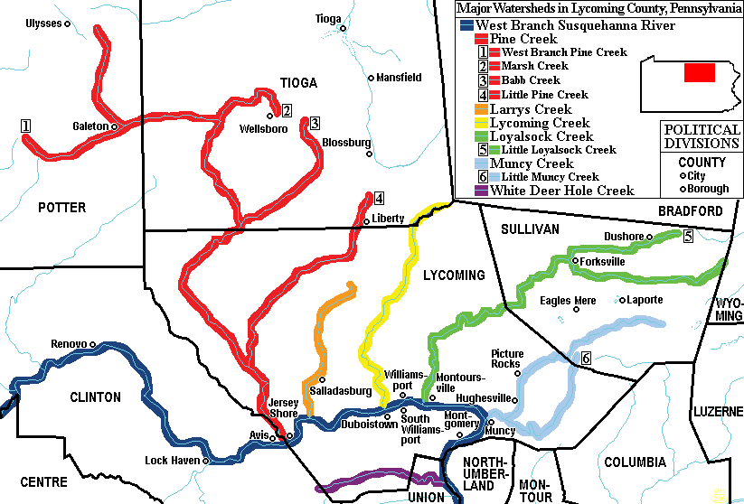
| 解説 | Map of Major Watersheds in Lycoming County, Pennsylvania, United States |
| 日付 | |
| 原典 | taken from US Census website [1] and modified by User:Ruhrfisch. |
| 作者 | US Census, Ruhrfisch |
| 許可 (ファイルの再利用) |
US Census / US Government work is public domain, my modifications licensed under the GNU Free Documentation License |
| その他のバージョン | four with minor errors |
ライセンス
この作品の著作権者であるI, Ruhrfischは、この作品を以下のライセンスで提供しています。

|
この文書は、フリーソフトウェア財団発行のGNUフリー文書利用許諾書 (GNU Free Documentation License) 1.2またはそれ以降のバージョンの規約に基づき、複製や再配布、改変が許可されます。不可変更部分、表紙、背表紙はありません。このライセンスの複製は、GNUフリー文書利用許諾書という章に含まれています。 |
| このファイルはクリエイティブ・コモンズ 表示-継承 3.0 非移植ライセンスのもとに利用を許諾されています。 | ||
| 帰属: I, Ruhrfisch | ||
| ||
| このライセンスのテンプレートは、GFDLのライセンス・アップデートによりこのファイルに追加されたものです。 |
|
|
 |
ファイルの履歴
過去の版のファイルを表示するには、その版の日時をクリックしてください。
| 日付と時刻 | サムネイル | 寸法 | 利用者 | コメント | |
|---|---|---|---|---|---|
| 現在の版 | 2009年3月22日 (日) 22:37 | | 823 × 558 (31キロバイト) | Mahahahaneapneap | Compressed |
| 2006年8月28日 (月) 16:13 |  | 823 × 558 (61キロバイト) | Ruhrfisch | {{Information |Description= Map of Major Watersheds in Lycoming County, Pennsylvania, USA. |Source= Information on river and stream positions and county boundaries is taken from US Census website[http://factfinder.census.gov/], modified by [[User:Ruhrfis | |
| 2006年8月24日 (木) 18:39 |  | 823 × 558 (62キロバイト) | Kmusser | ||
| 2006年3月14日 (火) 04:20 |  | 823 × 558 (30キロバイト) | Ruhrfisch | Map of Major Watersheds in Lycoming County Pennsylvania. Information on river and stream positions and county boundaries is taken from US Census website[http://factfinder.census.gov/] and modified by User:Ruhrfisch in March 2006 (with simplified color | |
| 2006年3月6日 (月) 17:09 |  | 823 × 558 (45キロバイト) | Ruhrfisch | Map of Major Watersheds in Lycoming County Pennsylvania. Information on river and stream positions and county boundaries is taken from US Census website[http://factfinder.census.gov/] and modified by User:Ruhrfisch in March 2006 (marsh Creek added). M |
ファイルの使用状況
以下のページがこのファイルを使用しています:
グローバルなファイル使用状況
以下に挙げる他のウィキがこの画像を使っています:
- en.wikipedia.org での使用状況
- Lycoming County, Pennsylvania
- West Branch Susquehanna River
- Muncy Creek
- Lycoming Creek
- Larrys Creek
- Pine Creek (Pennsylvania)
- Loyalsock Creek
- White Deer Hole Creek
- Little Muncy Creek
- Little Loyalsock Creek
- Fair Play Men
- West Branch Susquehanna Valley
- User:Ruhrfisch/Maps
- Wikipedia:WikiProject WikiFundi Content/White Deer Hole Creek
- fr.wikipedia.org での使用状況