
ファイル:MUTCD (2003-Edition) Adoption.svg

この SVG ファイルのこの PNG プレビューのサイズ: 709 × 600 ピクセル. その他の解像度: 284 × 240 ピクセル | 567 × 480 ピクセル | 908 × 768 ピクセル | 1,210 × 1,024 ピクセル | 2,420 × 2,048 ピクセル | 936 × 792 ピクセル。
元のファイル (SVG ファイル、936 × 792 ピクセル、ファイルサイズ: 88キロバイト)
ウィキメディア・コモンズのファイルページにある説明を、以下に表示します。
|
_Adoption.svg?uselang=ja)
_Adoption.svg?uselang=ja)
_Adoption.svg?uselang=ja&action=history)
_Adoption.svg)
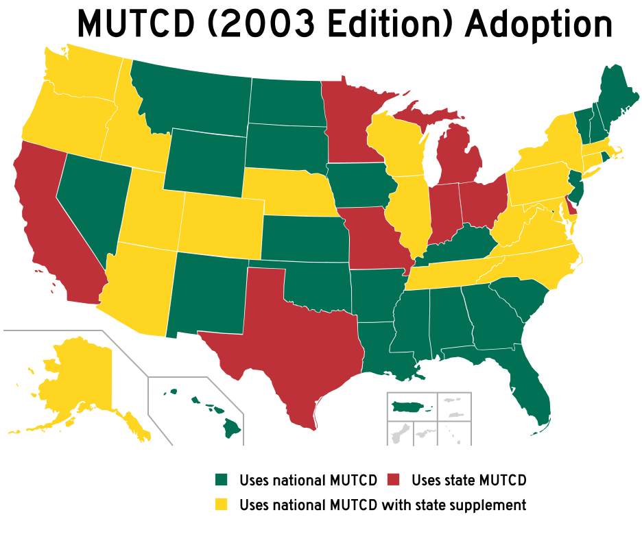
| 解説 | Modified to show MUTCD (2003 Edition) compliance of states | ||
| 日付 | (UTC) | ||
| 原典 | File:Blank USA, w territories.svg | ||
| 作者 | |||
| その他のバージョン |
All the below are of the states (and DC) only.
|
||
| SVG 開発 | この ベクター画像はAdobe Illustratorで作成されました。
|
この作品の著作権者である私は、この作品を以下のライセンスで提供します。

|
この文書は、フリーソフトウェア財団発行のGNUフリー文書利用許諾書 (GNU Free Documentation License) 1.2またはそれ以降のバージョンの規約に基づき、複製や再配布、改変が許可されます。不可変更部分、表紙、背表紙はありません。このライセンスの複製は、GNUフリー文書利用許諾書という章に含まれています。 |
| このファイルはクリエイティブ・コモンズ 表示-継承 3.0 非移植ライセンスのもとに利用を許諾されています。 | ||
| ||
| このライセンスのテンプレートは、GFDLのライセンス・アップデートによりこのファイルに追加されたものです。 |
元のアップロードログ
This image is a derivative work of the following images:
- File:Blank USA, w territories.svg licensed with GFDL
- 2009-01-30T01:59:59Z Hoshie 959x593 (98189 Bytes) Reverted to version as of 23:58, 14 January 2009 - rv myself; DC can be seen clearly.
- 2009-01-18T23:34:42Z Hoshie 959x593 (102341 Bytes) Put DC in an inset; fixed Tutuila (American Samoa)
- 2009-01-14T23:58:05Z Lokal Profil 959x593 (98189 Bytes) Code cleanup and removed stroke from Guam and American Samoa
- 2009-01-13T05:19:51Z Hoshie 959x593 (101361 Bytes) re did Guam and added American Samoa
- 2007-12-02T16:08:45Z Lokal Profil 959x593 (88960 Bytes) {{Information |Description=A blank map of the United States including Puerto Rico, Guam, the United States Virgin Islands, and the Northern Mariana Islands. |Source=This version was made by [[:User:Lokal_Profil|Lokal_Profil]]
Uploaded with derivativeFX
ファイルの履歴
過去の版のファイルを表示するには、その版の日時をクリックしてください。
| 日付と時刻 | サムネイル | 寸法 | 利用者 | コメント | |
|---|---|---|---|---|---|
| 現在の版 | 2009年4月7日 (火) 20:32 | | 936 × 792 (88キロバイト) | Overpush~commonswiki | corrections |
| 2009年4月7日 (火) 15:58 |  | 936 × 792 (88キロバイト) | Overpush~commonswiki | Updated info | |
| 2009年4月7日 (火) 15:57 |  | 936 × 792 (88キロバイト) | Overpush~commonswiki | Updated info | |
| 2009年4月6日 (月) 22:53 |  | 936 × 792 (87キロバイト) | Overpush~commonswiki | {{Information |Description=Modified to show MUTCD (2003 Edition) compliance of states |Source=*File:Blank_USA,_w_territories.svg |Date=2009-04-06 23:53 (UTC) |Author=*File:Blank_USA,_w_territories.svg: Lokal_Profil |othe |
ファイルの使用状況
以下の 2 ページがこのファイルを使用しています:
グローバルなファイル使用状況
以下に挙げる他のウィキがこの画像を使っています:
- ru.wikipedia.org での使用状況
- vi.wikipedia.org での使用状況
- zh.wikipedia.org での使用状況
_Adoption.svg)