
ファイル:Korea demilitarized zone map - 1969.jpg

このプレビューのサイズ: 800 × 225 ピクセル。 その他の解像度: 320 × 90 ピクセル | 640 × 180 ピクセル | 1,024 × 288 ピクセル | 1,280 × 360 ピクセル | 2,560 × 721 ピクセル | 11,456 × 3,226 ピクセル。
元のファイル (11,456 × 3,226 ピクセル、ファイルサイズ: 13.25メガバイト、MIME タイプ: image/jpeg)
ウィキメディア・コモンズのファイルページにある説明を、以下に表示します。
|
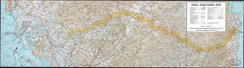
| 解説 |
English: A map of the Korean demilitarized zone (DMZ), produced by the CIA in 1969.
|
||||||
| 日付 | |||||||
| 原典 |
Library of Congress
|
||||||
| 作者 | Central Intelligence Agency | ||||||
| 許可 (ファイルの再利用) |
|
||||||

ファイルの履歴
過去の版のファイルを表示するには、その版の日時をクリックしてください。
| 日付と時刻 | サムネイル | 寸法 | 利用者 | コメント | |
|---|---|---|---|---|---|
| 現在の版 | 2010年2月16日 (火) 06:23 | 11,456 × 3,226 (13.25メガバイト) | Inductiveload | {{Information |Description={{en|A map of the Korean demilitarized zone (DMZ), produced by the CIA in 1969. :Relief shown by contours and spot heights. Depths shown by contours. :Oriented with north toward the upper right. :Scale 1:250,000.}} |Source=Lib |
ファイルの使用状況
以下の 2 ページがこのファイルを使用しています:
グローバルなファイル使用状況
以下に挙げる他のウィキがこの画像を使っています:
- az.wikipedia.org での使用状況
- bg.wikipedia.org での使用状況
- bn.wikipedia.org での使用状況
- cs.wikipedia.org での使用状況
- de.wikipedia.org での使用状況
- de.wiktionary.org での使用状況
- el.wikipedia.org での使用状況
- en.wikipedia.org での使用状況
- es.wikipedia.org での使用状況
- fr.wikipedia.org での使用状況
- hi.wikipedia.org での使用状況
- hu.wikipedia.org での使用状況
- hy.wikipedia.org での使用状況
- it.wikipedia.org での使用状況
- ka.wikipedia.org での使用状況
- ku.wikipedia.org での使用状況
- ml.wikipedia.org での使用状況
- mn.wikipedia.org での使用状況
- pnb.wikipedia.org での使用状況
- ro.wikipedia.org での使用状況
- simple.wikipedia.org での使用状況
- ta.wikipedia.org での使用状況
- ur.wikipedia.org での使用状況
- vi.wikipedia.org での使用状況
- zh.wikipedia.org での使用状況