
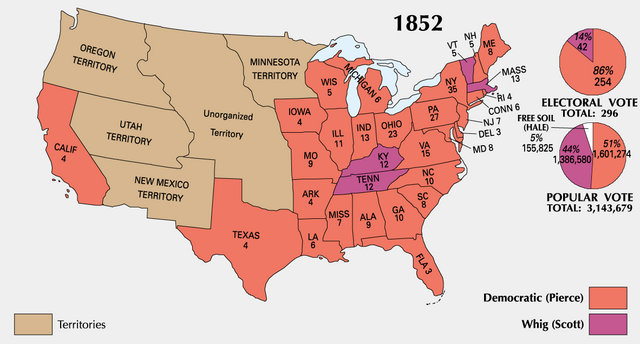
ファイル:ElectoralCollege1852-Large.png

このプレビューのサイズ: 800 × 430 ピクセル。 その他の解像度: 320 × 172 ピクセル | 640 × 344 ピクセル | 1,182 × 635 ピクセル。
元のファイル (1,182 × 635 ピクセル、ファイルサイズ: 93キロバイト、MIME タイプ: image/png)
ウィキメディア・コモンズのファイルページにある説明を、以下に表示します。
|

|
このファイルのベクター画像 (SVG) が利用できます。 使う目的に対し、元画像よりもSVGがより優れている場合、SVG画像を使用して下さい。
File:ElectoralCollege1852-Large.png → File:1852 US Electoral Map.svg
|
 |
| 解説 |
|
||||
| 原典 | National Atlas of the United States | ||||
| 作者 | Uploaded by Hephaestos | ||||
| 許可 (ファイルの再利用) |
|
||||
| その他のバージョン |
|


| History | |||||||||||||||
|---|---|---|---|---|---|---|---|---|---|---|---|---|---|---|---|
元のアップロードログLegend: (cur) = this is the current file, (del) = delete this old version, (rev) = revert to this old version. Click on date to download the file or see the image uploaded on that date.
|
ファイルの履歴
過去の版のファイルを表示するには、その版の日時をクリックしてください。
| 日付と時刻 | サムネイル | 寸法 | 利用者 | コメント | |
|---|---|---|---|---|---|
| 現在の版 | 2006年1月22日 (日) 14:11 | | 1,182 × 635 (93キロバイト) | Maksim | La bildo estas kopiita de wikipedia:en. La originala priskribo estas: {{PD-USGov-Atlas}} Category:Historical maps of the United States {| border="1" ! date/time || username || edit summary |---- | 01:22, 22 January 2006 || en:User:DLJessup || |
ファイルの使用状況
以下のページがこのファイルを使用しています:
グローバルなファイル使用状況
以下に挙げる他のウィキがこの画像を使っています:
- eo.wikipedia.org での使用状況
- it.wikipedia.org での使用状況
- ko.wikipedia.org での使用状況
- uk.wikipedia.org での使用状況