
ファイル:Egypt and neighbors 1880 map de.png
このプレビューのサイズ: 606 × 600 ピクセル。 その他の解像度: 243 × 240 ピクセル | 485 × 480 ピクセル | 776 × 768 ピクセル | 1,035 × 1,024 ピクセル | 2,122 × 2,100 ピクセル。
元のファイル (2,122 × 2,100 ピクセル、ファイルサイズ: 896キロバイト、MIME タイプ: image/png)
ウィキメディア・コモンズのファイルページにある説明を、以下に表示します。
|
概要
| 解説 |
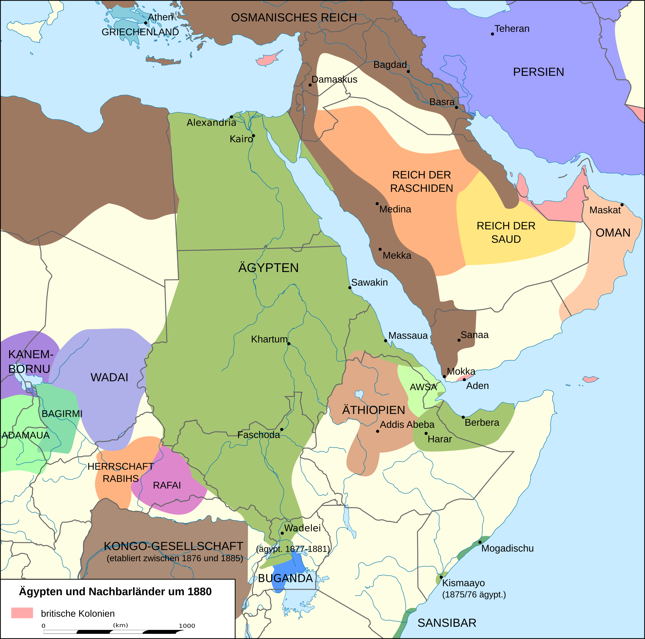
English: Map of Egypt and its neighbors 1880 in German.
Deutsch: Karte Ägyptens und seiner Nachbarn 1880.
Quellen:
|
| 日付 | |
| 原典 | 投稿者自身による著作物, derivate of File:Africa location map.svg |
| 作者 | Don-kun, Eric Gaba (Sting - fr:Sting) |
| その他のバージョン |
 |
.png)
ライセンス
この作品の著作権者である私は、この作品を以下のライセンスで提供します。

|
この文書は、フリーソフトウェア財団発行のGNUフリー文書利用許諾書 (GNU Free Documentation License) 1.2またはそれ以降のバージョンの規約に基づき、複製や再配布、改変が許可されます。不可変更部分、表紙、背表紙はありません。このライセンスの複製は、GNUフリー文書利用許諾書という章に含まれています。 |
このファイルはクリエイティブ・コモンズ 表示 3.0 非移植ライセンスのもとに利用を許諾されています。
- あなたは以下の条件に従う場合に限り、自由に
- 共有 – 本作品を複製、頒布、展示、実演できます。
- 再構成 – 二次的著作物を作成できます。
- あなたの従うべき条件は以下の通りです。
- 表示 – あなたは適切なクレジットを表示し、ライセンスへのリンクを提供し、変更があったらその旨を示さなければなりません。これらは合理的であればどのような方法で行っても構いませんが、許諾者があなたやあなたの利用行為を支持していると示唆するような方法は除きます。
あなたは上記のライセンスから、どれか一つ以上を選択できます。
ファイルの履歴
過去の版のファイルを表示するには、その版の日時をクリックしてください。
| 日付と時刻 | サムネイル | 寸法 | 利用者 | コメント | |
|---|---|---|---|---|---|
| 現在の版 | 2016年1月28日 (木) 20:39 | | 2,122 × 2,100 (896キロバイト) | Don-kun | see discussion and following sources |
| 2015年5月6日 (水) 16:34 |  | 2,123 × 2,101 (843キロバイト) | Middayexpress | The area was indeed at the time controlled by Somali sultanates, not the Zanzibaris: https://commons.wikimedia.org/wiki/File:1867_Horn_of_Africa_map.jpg | |
| 2015年5月6日 (水) 04:58 |  | 2,123 × 2,101 (840キロバイト) | Don-kun | you obviously didnt | |
| 2015年5月5日 (火) 17:15 |  | 2,123 × 2,101 (843キロバイト) | Middayexpress | The area was controlled by Somali Sultanates. Those were the polities that the Italian colonial administration actually signed treaties with, not the Zanzibaris. Please see: https://en.wikipedia.org/wiki/Italian_Somaliland https://en.wikipedia.org/wi... | |
| 2015年5月5日 (火) 15:14 |  | 2,123 × 2,101 (840キロバイト) | Don-kun | unless you can cite a source confirming the modern border of kenia for 1880 and so forth the map remins as before | |
| 2015年5月2日 (土) 19:03 |  | 2,123 × 2,101 (843キロバイト) | Middayexpress | Zanzibari authority was indeed only nominal. The Geledi Sultanate actually resided in and ruled the area. | |
| 2015年5月1日 (金) 10:12 |  | 2,123 × 2,101 (840キロバイト) | Don-kun | as stated before: Sansibarian garrison in Mogadishu since 1874 and insist on todays border for 1880 is just absurd | |
| 2015年4月30日 (木) 20:45 |  | 2,123 × 2,101 (843キロバイト) | AcidSnow | They had no authority in Mogadishu, let alone any other Somali city. All power was in the hands of the Geledi Sultanate. | |
| 2015年2月24日 (火) 05:54 |  | 2,123 × 2,101 (840キロバイト) | Don-kun | Reverted to version as of 21:59, 2 November 2011 Sansibarian garrison in Mogadishu since 1874, Kenian/Somalian border nonexistent in that time | |
| 2015年2月23日 (月) 22:17 |  | 2,123 × 2,101 (843キロバイト) | AcidSnow | The Geledi controlled southern Somalia. |
ファイルの使用状況
以下のページがこのファイルを使用しています:
グローバルなファイル使用状況
以下に挙げる他のウィキがこの画像を使っています:
- azb.wikipedia.org での使用状況
- de.wikipedia.org での使用状況
- en.wikipedia.org での使用状況
- fi.wikipedia.org での使用状況
- fr.wikipedia.org での使用状況
- it.wikipedia.org での使用状況
- it.wikiquote.org での使用状況
- ka.wikipedia.org での使用状況
- ta.wikipedia.org での使用状況
- uk.wikipedia.org での使用状況