
ファイル:Dry line-Satellite view.jpg
高解像度版はありません。
Dry_line-Satellite_view.jpg (481 × 348 ピクセル、ファイルサイズ: 103キロバイト、MIME タイプ: image/jpeg)
ウィキメディア・コモンズのファイルページにある説明を、以下に表示します。
|
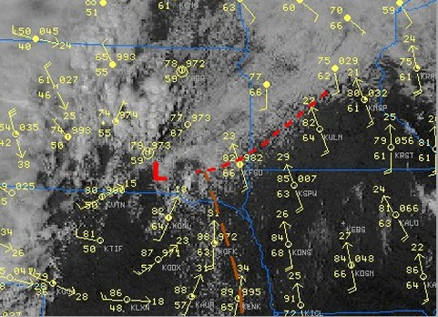
| 解説 | Satellite view in visible range of convection along a Dry line (yellow line) and surface station data showing temperature around 86F in the whole sector but dew points in the 60's east of it and in the 50' West of it. | |||
| 日付 | ||||
| 原典 | National Weather Service (NOAA) in a case Study of the Southeast South Dakota Tornadoes of 16 September 2006 | |||
| 作者 | Pierre cb | |||
| 許可 (ファイルの再利用) |
|
ファイルの履歴
過去の版のファイルを表示するには、その版の日時をクリックしてください。
| 日付と時刻 | サムネイル | 寸法 | 利用者 | コメント | |
|---|---|---|---|---|---|
| 現在の版 | 2016年6月27日 (月) 13:30 | | 481 × 348 (103キロバイト) | Pierre cb | Cropped version |
| 2007年10月18日 (木) 23:52 |  | 500 × 493 (152キロバイト) | Pierre cb | {{Information |Description=Satellite view in visible range of convection along a Dry line (yellow line) and surface station data showing temperature around 86F in the whole sector but dew points in the 60's east of it and in the 50' West of it. |Source=[h |
ファイルの使用状況
以下のページがこのファイルを使用しています:
グローバルなファイル使用状況
以下に挙げる他のウィキがこの画像を使っています:
- fr.wikipedia.org での使用状況