
ファイル:Dioecesis Thraciae 400 AD.png
高解像度版はありません。
Dioecesis_Thraciae_400_AD.png (461 × 352 ピクセル、ファイルサイズ: 205キロバイト、MIME タイプ: image/png)
ウィキメディア・コモンズのファイルページにある説明を、以下に表示します。
|
概要
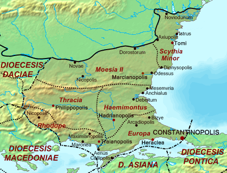
| 解説 | Map of the Diocese of Thrace (Dioecesis Thraciae) ca. 400 AD, showing the subordinate provinces and the major cities. |
| 日付 | |
| 原典 |
Base map found at en:Topographic map#Global 1-kilometer map, otherwise self-made. Data based on maps in atlases and the internet and on contemporary sources, primarily the Notitia Dignitatum. Note: The exact course of the provincial boundaries is very uncertain and in many cases only approximate. |
| 作者 | Cplakidas |
ライセンス
| この著作物の著作権者である私は、この著作物における権利を放棄しパブリックドメインとします。これは全世界で適用されます。 一部の国では、これが法的に可能ではない場合があります。その場合は、次のように宣言します。 私は、あらゆる人に対して、法により必要とされている条件を除き、如何なる条件も課すことなく、あらゆる目的のためにこの著作物を使用する権利を与えます。 |
ファイルの履歴
過去の版のファイルを表示するには、その版の日時をクリックしてください。
| 日付と時刻 | サムネイル | 寸法 | 利用者 | コメント | |
|---|---|---|---|---|---|
| 現在の版 | 2017年5月20日 (土) 14:30 | | 461 × 352 (205キロバイト) | Julieta39 | Antic shoreline of the Danube mouths since Grigore Antipa's "Black Sea" (1940) and Andrei Nacu's paleomap [https://fr.wikipedia.org/wiki/Delta_du_Danube#/media/File:Danube_Delta_evolution.gif]. |
| 2007年10月2日 (火) 16:25 |  | 461 × 352 (139キロバイト) | Cplakidas | {{Information |Description=Map of the Diocese of Thrace (''Dioecesis Thraciae'') ca. 400 AD, showing the subordinate provinces and the major cities. |Source=Base map found at en:Topographic map#Global 1-kilometer map, other |
ファイルの使用状況
以下のページがこのファイルを使用しています:
グローバルなファイル使用状況
以下に挙げる他のウィキがこの画像を使っています:
- an.wikipedia.org での使用状況
- ar.wikipedia.org での使用状況
- arz.wikipedia.org での使用状況
- az.wikipedia.org での使用状況
- be.wikipedia.org での使用状況
- bg.wikipedia.org での使用状況
- ca.wikipedia.org での使用状況
- cs.wikipedia.org での使用状況
- da.wikipedia.org での使用状況
- de.wikipedia.org での使用状況
- de.wikivoyage.org での使用状況
- el.wikipedia.org での使用状況
- en.wikipedia.org での使用状況
- es.wikipedia.org での使用状況
このファイルのグローバル使用状況を表示する。