
ファイル:Connacht locator map.svg

この SVG ファイルのこの PNG プレビューのサイズ: 459 × 599 ピクセル. その他の解像度: 184 × 240 ピクセル | 368 × 480 ピクセル | 589 × 768 ピクセル | 785 × 1,024 ピクセル | 1,570 × 2,048 ピクセル | 1,264 × 1,649 ピクセル。
元のファイル (SVG ファイル、1,264 × 1,649 ピクセル、ファイルサイズ: 593キロバイト)
ウィキメディア・コモンズのファイルページにある説明を、以下に表示します。
|
概要
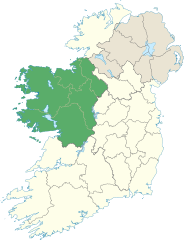
| 解説 | Locator map of Connacht. |
| 日付 | (UTC) |
| 原典 | |
| 作者 |
|
ライセンス
この作品の著作権者である私は、この作品を以下のライセンスで提供します。
このファイルはクリエイティブ・コモンズ 表示-継承 3.0 非移植ライセンスのもとに利用を許諾されています。
- あなたは以下の条件に従う場合に限り、自由に
- 共有 – 本作品を複製、頒布、展示、実演できます。
- 再構成 – 二次的著作物を作成できます。
- あなたの従うべき条件は以下の通りです。
- 表示 – あなたは適切なクレジットを表示し、ライセンスへのリンクを提供し、変更があったらその旨を示さなければなりません。これらは合理的であればどのような方法で行っても構いませんが、許諾者があなたやあなたの利用行為を支持していると示唆するような方法は除きます。
- 継承 – もしあなたがこの作品をリミックスしたり、改変したり、加工した場合には、あなたはあなたの貢献部分を元の作品とこれと同一または互換性があるライセンスの下に頒布しなければなりません。
ファイルの履歴
過去の版のファイルを表示するには、その版の日時をクリックしてください。
| 日付と時刻 | サムネイル | 寸法 | 利用者 | コメント | |
|---|---|---|---|---|---|
| 現在の版 | 2013年6月8日 (土) 14:18 | | 1,264 × 1,649 (593キロバイト) | Setanta Saki | Including Aran Islands are part of province of Connacht |
| 2012年1月7日 (土) 19:50 |  | 1,450 × 1,807 (687キロバイト) | NikNaks | Fix | |
| 2012年1月7日 (土) 19:47 |  | 1,450 × 1,807 (687キロバイト) | NikNaks | Removing modern boundaries | |
| 2012年1月7日 (土) 18:20 |  | 1,450 × 1,807 (708キロバイト) | NikNaks | Updating to new map | |
| 2012年1月7日 (土) 17:53 |  | 400 × 500 (281キロバイト) | NikNaks93 | == {{int:filedesc}} == {{Information |Description=Locator map of Connacht. |Source=*File:Ireland_trad_counties_named.svg |Date=2012-01-07 17:50 (UTC) |Author=*File:Ireland_trad_counties_named.svg: *[[:File:Population_density_of_Ireland_map2002 |
ファイルの使用状況
グローバルなファイル使用状況
以下に挙げる他のウィキがこの画像を使っています:
- ar.wikipedia.org での使用状況
- ca.wikipedia.org での使用状況
- cs.wikipedia.org での使用状況
- da.wikipedia.org での使用状況
- en.wikipedia.org での使用状況
- Achill Island
- Connacht
- Croagh Patrick
- List of Ireland-related topics
- Twelve Bens
- Lists of mountains in Ireland
- Devilsmother
- Leenaun
- Knocknarea
- Mweelrea
- Nephin
- Dartry Mountains
- Benbaun
- Benbulbin
- Slievemore
- Curlew Mountains
- Barrclashcame
- Croaghaun
- Slieve Carr
- Binn idir an dá Log
- Ben Gorm
- Maumtrasna
- Ox Mountains
- Partry Mountains
- Errisbeg
- Nephin Beg
- Nephin Beg Range
- List of Irish counties by highest point
- Truskmore
- Knockalongy
- Template:Mountains and hills of Connacht
- Sheeffry Hills
- Knockmore, Mayo
- Bencorr
- Knocknashee
- Truskmore SE Cairn
- List of mountains and hills of County Mayo
- Maumturks
- Birreencorragh
- Slieve Bawn
- Corcogemore
- Lackavrea
- Letterbreckaun
- Binn Mhór
- Binn Chaonaigh
- Garraun (Galway)
このファイルのグローバル使用状況を表示する。