
ファイル:Caltrain map.svg

この SVG ファイルのこの PNG プレビューのサイズ: 608 × 599 ピクセル. その他の解像度: 243 × 240 ピクセル | 487 × 480 ピクセル | 779 × 768 ピクセル | 1,039 × 1,024 ピクセル | 2,077 × 2,048 ピクセル | 7,476 × 7,370 ピクセル。
元のファイル (SVG ファイル、7,476 × 7,370 ピクセル、ファイルサイズ: 38キロバイト)
ウィキメディア・コモンズのファイルページにある説明を、以下に表示します。
|
概要
| 解説 | |
| 原典 |
次の画像を基にした投稿者自身による著作物: Image:Wfm caltrain.png/source. |
| 作者 | User:Finlay McWalter |
| その他のバージョン |
Caltrain map horizontal.svg:  |
| SVG 開発 |
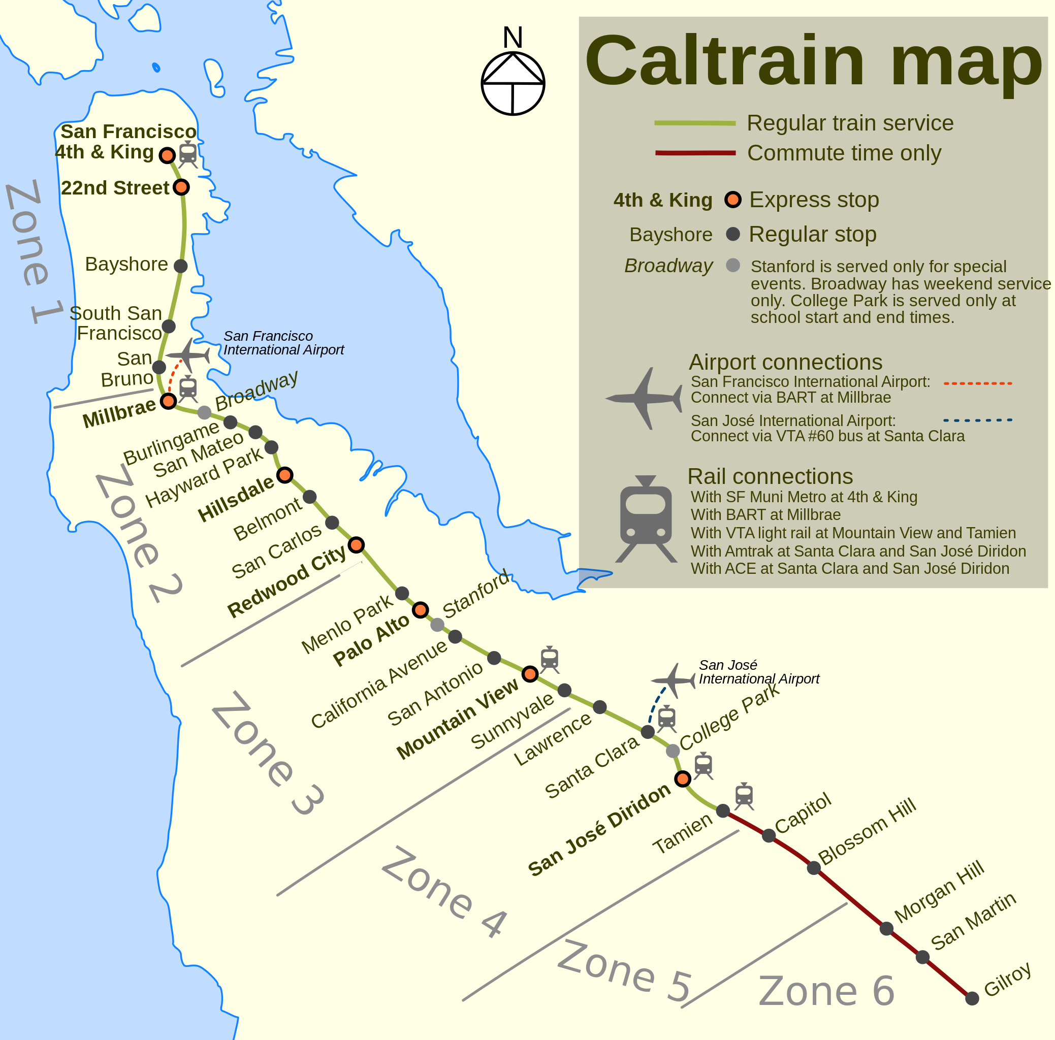
Method of production
Drawn by Finlay McWalter in the following manner:
- An outline was rendered using Panmap running NOAA WVS (world vector shoreline).
- This was exported (as a bitmap, all that Panmap can do) to Paint Shop Pro. This was manually repaired (holes filled, island groups tweaked, and shoreline details clarified or erased). Then the bitmap was floodfilled, so that the subsequent vectoriser will produce polygons rather than lines.
- This was imported into Inkscape and vectorised using Inkscape's "path->trace bitmap" function.
- All details were then manually drawn.
Notes
Differences between this version and the offical Caltrain map:
- The official Caltrain map is copyrighted by PCJPB.
- It's bigger than the Caltrain map, and clearer when printed.
- The official map doesn't denote express stops.
- The official version doesn't have acute over e in San José.
- This version shows the ACE interchange at Santa Clara, which the official one doesn't.
ライセンス

|
この文書は、フリーソフトウェア財団発行のGNUフリー文書利用許諾書 (GNU Free Documentation License) 1.2またはそれ以降のバージョンの規約に基づき、複製や再配布、改変が許可されます。不可変更部分、表紙、背表紙はありません。このライセンスの複製は、GNUフリー文書利用許諾書という章に含まれています。 |
| このファイルはクリエイティブ・コモンズ 表示-継承 3.0 非移植ライセンスのもとに利用を許諾されています。 | ||
| ||
| このライセンスのテンプレートは、GFDLのライセンス・アップデートによりこのファイルに追加されたものです。 |
このファイルはクリエイティブ・コモンズ 表示-継承 1.0 一般ライセンスのもとに利用を許諾されています。
- あなたは以下の条件に従う場合に限り、自由に
- 共有 – 本作品を複製、頒布、展示、実演できます。
- 再構成 – 二次的著作物を作成できます。
- あなたの従うべき条件は以下の通りです。
- 表示 – あなたは適切なクレジットを表示し、ライセンスへのリンクを提供し、変更があったらその旨を示さなければなりません。これらは合理的であればどのような方法で行っても構いませんが、許諾者があなたやあなたの利用行為を支持していると示唆するような方法は除きます。
- 継承 – If you alter, transform, or build upon this work, you must distribute the resulting work under the same license as the original.
ファイルの履歴
過去の版のファイルを表示するには、その版の日時をクリックしてください。
| 日付と時刻 | サムネイル | 寸法 | 利用者 | コメント | |
|---|---|---|---|---|---|
| 現在の版 | 2024年4月3日 (水) 08:33 | | 7,476 × 7,370 (38キロバイト) | Saucy | Update to reflect current service |
| 2018年1月21日 (日) 23:28 |  | 7,476 × 7,370 (39キロバイト) | JoKalliauer | upon request User_talk:Mliu92#Sorry_for_edditing_File:Sheffield_Area_1950.svg, took version of (03:56, 23. Aug. 2006) | |
| 2015年5月21日 (木) 21:12 |  | 748 × 737 (125キロバイト) | Mliu92 | Accidentally uploaded older copy of the file last time. | |
| 2015年5月21日 (木) 21:10 |  | 748 × 737 (125キロバイト) | Mliu92 | Completely deleted old station labels and retyped from scratch to flush out legacy fonts. | |
| 2015年5月21日 (木) 20:44 |  | 748 × 737 (133キロバイト) | Mliu92 | Another iteration. Directly replaced all instances of "Trebuchet MS" with "Bitstream Vera Sans". | |
| 2015年5月21日 (木) 20:40 |  | 748 × 737 (133キロバイト) | Mliu92 | Another attempt to fix the fonts. Some direct .svg cleanup may be required if this doesn't work. | |
| 2015年5月21日 (木) 19:29 |  | 748 × 737 (132キロバイト) | Mliu92 | Updated font (from proprietary "Trebuchet MS" to free "Bitstream Vera Sans") to improve display and readability, modified legend layout (selective bolding), changed special service stop icon and modified notes on special stops, condensed rail connectio... | |
| 2006年8月23日 (水) 03:56 |  | 748 × 737 (134キロバイト) | ChrisRuvolo | update express stations based on current data (no differentiation between A and B express groups) | |
| 2006年8月22日 (火) 16:31 |  | 748 × 737 (134キロバイト) | ChrisRuvolo | remove Bayshore, fix up legend | |
| 2006年8月21日 (月) 15:40 |  | 748 × 737 (136キロバイト) | ChrisRuvolo | break-up "Stanford Stadium" labeling, shrink size of compass rose |
ファイルの使用状況
このファイルを使用しているページはありません。
グローバルなファイル使用状況
以下に挙げる他のウィキがこの画像を使っています:
- bg.wikipedia.org での使用状況
- de.wikipedia.org での使用状況
- de.wikivoyage.org での使用状況
- en.wikipedia.org での使用状況
- en.wikivoyage.org での使用状況
- eo.wikipedia.org での使用状況
- it.wikivoyage.org での使用状況
- ko.wikipedia.org での使用状況
- www.wikidata.org での使用状況