
ファイル:BattleOfFortWashingtonMapBySauthier.jpg

このプレビューのサイズ: 330 × 600 ピクセル。 その他の解像度: 132 × 240 ピクセル | 264 × 480 ピクセル | 422 × 768 ピクセル | 563 × 1,024 ピクセル | 2,528 × 4,595 ピクセル。
元のファイル (2,528 × 4,595 ピクセル、ファイルサイズ: 4.79メガバイト、MIME タイプ: image/jpeg)
ウィキメディア・コモンズのファイルページにある説明を、以下に表示します。
|
概要
| 解説 |
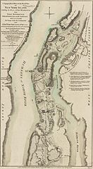
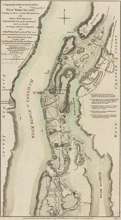
English: This map depicts the northern end of Manhattan, and the military fortifications in the area in 1776, during the American Revolutionary War. It has markings describing the military movements of the Battle of Fort Washington, fought November 16, 1776.
The map's caption reads: A Topographical Map of the Northn. Part of New York Island, Exhibiting the Plan of Fort Washington, now Fort Knyphausen, With the Rebels Lines to the Southward, which were forced by the Troops under the Command of the Rt. Honble. Earl Percy, on the 16th Novr. 1776, and Survey'd immediately after by Order of his Lordship, By Claude Joseph Sauthier. To which is added the Attack made to the Northd. by the Hessians Survey'd by Order of Lieutt. Genl. Knyphausen. Published by Permission of The Rt. Honble. the Commissioners of Trade & Plantations. By Wm. Faden, 1777. |
|||||||||||||||||||
| 日付 | ||||||||||||||||||||
| 原典 |
From the Boston Public Library Digital Map Collection: http://maps.bpl.org/details_10863/ |
|||||||||||||||||||
| 作者 |
|
|||||||||||||||||||
| その他のバージョン |
 |
|||||||||||||||||||
ライセンス
このファイルはアメリカ合衆国においてパブリックドメインの状態にあります。これは多くの場合、最初の公表が1929年1月1日以前であるために著作権が消滅したアメリカ合衆国の著作物に適用されます。より詳細な説明については、このページをご覧ください。
|
 | |
 |
このファイルはアメリカ合衆国以外ではパブリックドメインの状態にはない可能性があり、この点は、特に、カナダ、中華人民共和国(香港・マカオを除く)、ドイツ、メキシコ及びスイスのようにアメリカ合衆国の著作物の著作権の保護期間について相互主義を採用していない国・地域で当てはまります。作者や公表年は必要な情報であり、条件とされるべきものです。詳細についてはWikipedia:Public domain及びWikipedia:Copyrightsをご覧ください。
|
|
このファイルは、パブリックドメインの状態にある平面的な美術の著作物を写真術によって忠実に複製したものです。このような複製はアメリカ合衆国においてパブリックドメインの状態にあります。その他の地域では再利用に制限がかかる場合があります。詳しくはReuse of PD-Art photographsをご覧ください。美術の著作物としての原図は、次の理由によりパブリックドメインの状態にあります。
| ||||
ファイルの履歴
過去の版のファイルを表示するには、その版の日時をクリックしてください。
| 日付と時刻 | サムネイル | 寸法 | 利用者 | コメント | |
|---|---|---|---|---|---|
| 現在の版 | 2009年4月22日 (水) 19:27 | | 2,528 × 4,595 (4.79メガバイト) | Magicpiano | {{Information |Description={{en|1=This map depicts the northern end of w:Manhattan, and the military fortifications in the area in 1776, during the w:American Revolutionary War. It has markings describing the military movements of the [[w:Battl |
ファイルの使用状況
以下のページがこのファイルを使用しています:
グローバルなファイル使用状況
以下に挙げる他のウィキがこの画像を使っています:
- en.wikipedia.org での使用状況
- es.wikipedia.org での使用状況
- fr.wikipedia.org での使用状況
- it.wikipedia.org での使用状況
- nl.wikipedia.org での使用状況
- pt.wikipedia.org での使用状況
- www.wikidata.org での使用状況