
ファイル:Antalya districts.png
このプレビューのサイズ: 736 × 599 ピクセル。 その他の解像度: 295 × 240 ピクセル | 589 × 480 ピクセル | 954 × 777 ピクセル。
元のファイル (954 × 777 ピクセル、ファイルサイズ: 46キロバイト、MIME タイプ: image/png)
ウィキメディア・コモンズのファイルページにある説明を、以下に表示します。
|
概要
| 解説 |
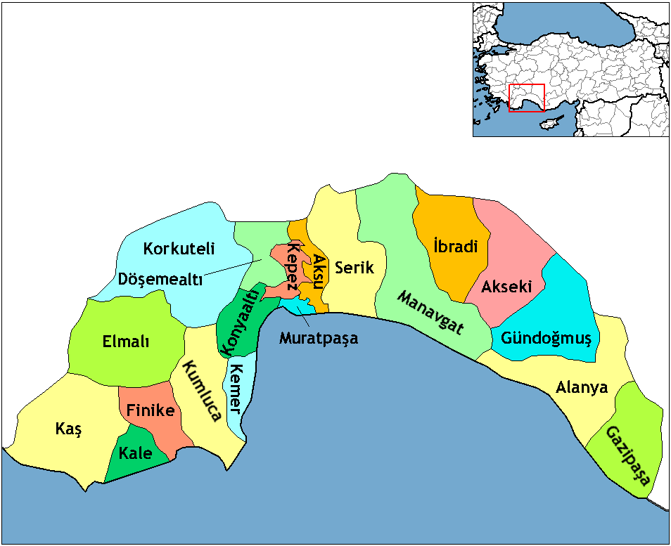
English: Map of the districts of Antalya province in Turkey. Created by Rarelibra 16:59, 1 December 2006 (UTC) for public domain use, using MapInfo Professional v8.5 and various mapping resources. Edited by One Homo Sapiens Corrected text where İ,Ş,ı,ğ,or ş occurs in name. Source: [statoids-com]. Increased font size and enhanced color differences among adjacent districts. |
| 日付 | 2006年12月1日 (当初のアップロード日) |
| 原典 | コンピュータが読み取れる情報は提供されていませんが、投稿者自身による著作物だと推定されます(著作権の主張に基づく) |
| 作者 | コンピュータが読み取れる情報は提供されていませんが、Rarelibraだと推定されます(著作権の主張に基づく) |
ライセンス
| この著作物の著作権者である私は、この著作物における権利を放棄しパブリックドメインとします。これは全世界で適用されます。 一部の国では、これが法的に可能ではない場合があります。その場合は、次のように宣言します。 私は、あらゆる人に対して、法により必要とされている条件を除き、如何なる条件も課すことなく、あらゆる目的のためにこの著作物を使用する権利を与えます。 |
This image was intentionally uploaded with a border. Please do not remove the border. Upload a new version under a different filename without a border if you want a version without a border.
|
ファイルの履歴
過去の版のファイルを表示するには、その版の日時をクリックしてください。
| 日付と時刻 | サムネイル | 寸法 | 利用者 | コメント | |
|---|---|---|---|---|---|
| 現在の版 | 2018年2月18日 (日) 23:24 | | 954 × 777 (46キロバイト) | Effeietsanders | Removed border by cropping 10 % horizontally and 5 % vertically using CropTool with precise mode. |
| 2009年1月1日 (木) 19:18 |  | 1,056 × 816 (67キロバイト) | Onur | {{Information |Description= |Source= |Date= |Author= |Permission= |other_versions= }} | |
| 2008年12月28日 (日) 20:43 |  | 1,056 × 816 (39キロバイト) | One Homo Sapiens | Corrected text where İ,Ş,ı,ğ,or ş occurs in name. Source: [statoids-com]. Increased font size and enhanced color differences among adjacent districts. | |
| 2006年12月1日 (金) 16:59 |  | 1,056 × 816 (32キロバイト) | Rarelibra | Map of the districts of Antalya province in Turkey. Created by ~~~~ for public domain use, using MapInfo Professional v8.5 and various mapping resources. |
ファイルの使用状況
以下のページがこのファイルを使用しています:
グローバルなファイル使用状況
以下に挙げる他のウィキがこの画像を使っています:
- azb.wikipedia.org での使用状況
- az.wikipedia.org での使用状況
- ba.wikipedia.org での使用状況
- be.wikipedia.org での使用状況
- br.wikipedia.org での使用状況
- ca.wikipedia.org での使用状況
- da.wikipedia.org での使用状況
- de.wikipedia.org での使用状況
- Alanya
- Antalya (Provinz)
- Gazipaşa
- Akseki
- Kumluca (Antalya)
- Vorlage:Navigationsleiste Landkreise der Provinz Antalya
- Serik (Landkreis)
- Korkuteli (Landkreis)
- Finike (Landkreis)
- Elmalı (Landkreis)
- İbradı (Landkreis)
- Kemer (Landkreis, Antalya)
- Kaş (Landkreis)
- Gündoğmuş
- Demre
- Aksu (Antalya)
- Döşemealtı
- Kepez (Antalya)
- Konyaaltı
- Muratpaşa
- diq.wikipedia.org での使用状況
- en.wikipedia.org での使用状況
このファイルのグローバル使用状況を表示する。