
ファイル:American Samoa Districts.png
このプレビューのサイズ: 776 × 600 ピクセル。 その他の解像度: 311 × 240 ピクセル | 621 × 480 ピクセル | 994 × 768 ピクセル | 1,280 × 989 ピクセル | 2,112 × 1,632 ピクセル。
元のファイル (2,112 × 1,632 ピクセル、ファイルサイズ: 36キロバイト、MIME タイプ: image/png)
ウィキメディア・コモンズのファイルページにある説明を、以下に表示します。
|

|
この地図画像は、ベクターイメージである SVG ファイルとして再作成されるべきです。これにはいくつかの利点があります。詳しくはCommons:Media for cleanupを参照してください。この画像の SVG 形式がすでに利用可能である場合は、アップロードしてください。アップロード後、この画像にあるこのテンプレートを{{Vector version available|新しい画像ファイル名.svg}}テンプレートで置き換えてください。
|
概要
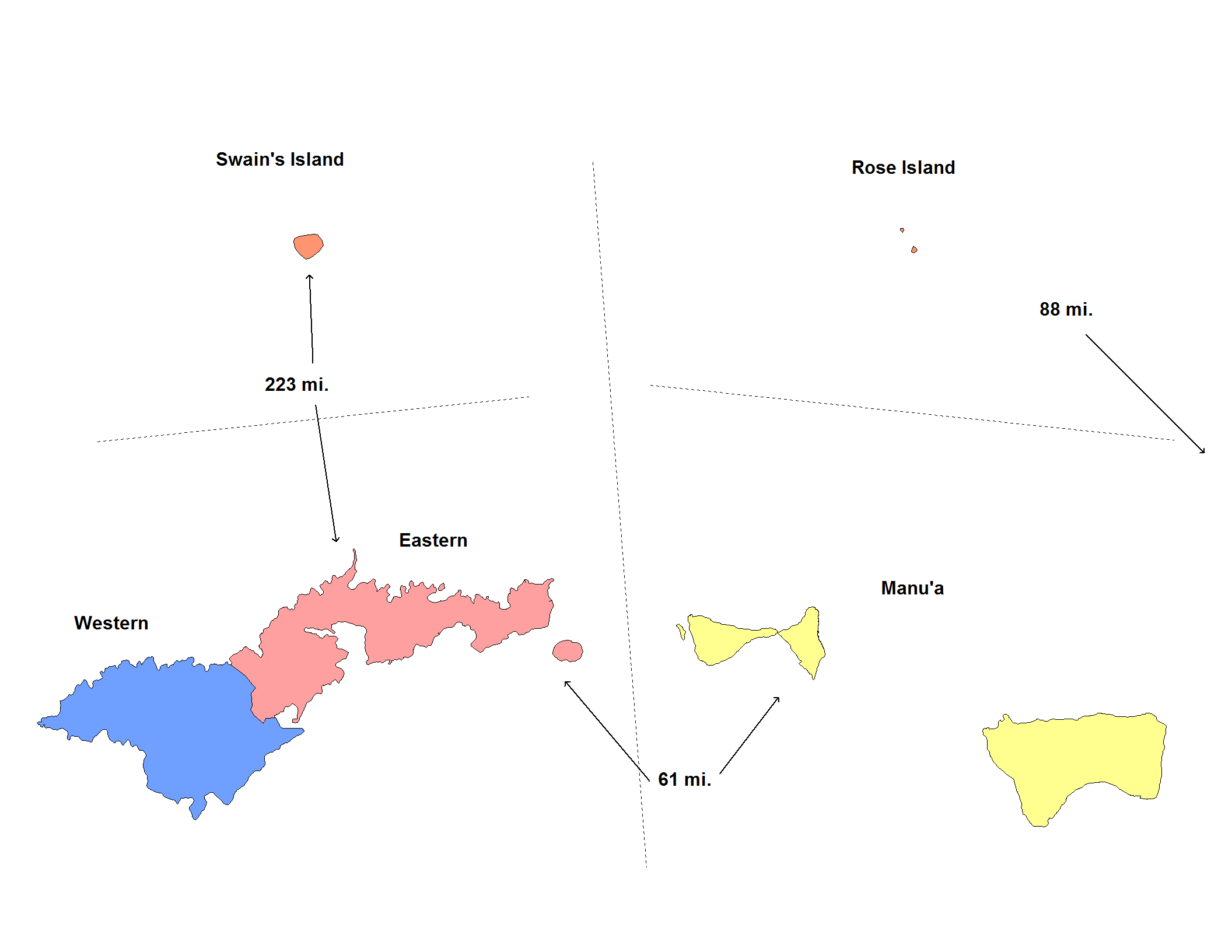
| 解説 | Map of the districts of American Samoa. Created by Rarelibra for public domain use. Created using MapInfo Professional v7.5 and various mapping resources. |
| 日付 | 2006年11月20日 (当初のアップロード日) |
| 原典 | コンピュータが読み取れる情報は提供されていませんが、投稿者自身による著作物だと推定されます(著作権の主張に基づく) |
| 作者 | コンピュータが読み取れる情報は提供されていませんが、Electionworldだと推定されます(著作権の主張に基づく) |
ライセンス
| この著作物の著作権者である私は、この著作物における権利を放棄しパブリックドメインとします。これは全世界で適用されます。 一部の国では、これが法的に可能ではない場合があります。その場合は、次のように宣言します。 私は、あらゆる人に対して、法により必要とされている条件を除き、如何なる条件も課すことなく、あらゆる目的のためにこの著作物を使用する権利を与えます。 |
ファイルの履歴
過去の版のファイルを表示するには、その版の日時をクリックしてください。
| 日付と時刻 | サムネイル | 寸法 | 利用者 | コメント | |
|---|---|---|---|---|---|
| 現在の版 | 2020年6月1日 (月) 05:14 | | 2,112 × 1,632 (36キロバイト) | Heitordp | Reverted to version as of 17:42, 11 January 2008 (UTC) keep previous map, many articles refer to its colors and positions |
| 2020年6月1日 (月) 03:32 | 2,104 × 808 (26キロバイト) | Heitordp | Removed excessive blank space, removed distances, improved shapes, moved islands to reflect real relative positions, adjusted colors, corrected atoll names, increased font size for legibility in infobox | ||
| 2008年1月11日 (金) 17:42 |  | 2,112 × 1,632 (36キロバイト) | Rarelibra | update map | |
| 2006年11月20日 (月) 22:22 |  | 953 × 598 (11キロバイト) | Electionworld | == Summary == Map of the districts of American Samoa. Created by Rarelibra for public domain use. Created using MapInfo Professional v7.5 and various mapping resources. == Licensing == {{PD-self}} Category:Maps of American Samoa |
ファイルの使用状況
以下のページがこのファイルを使用しています:
グローバルなファイル使用状況
以下に挙げる他のウィキがこの画像を使っています:
- de.wikipedia.org での使用状況
- en.wikipedia.org での使用状況
- eu.wikipedia.org での使用状況
- fr.wikipedia.org での使用状況
- fy.wikipedia.org での使用状況
- he.wikipedia.org での使用状況
- it.wikipedia.org での使用状況
- ka.wikipedia.org での使用状況
- nl.wikipedia.org での使用状況
- os.wikipedia.org での使用状況
- pt.wikipedia.org での使用状況
- ru.wikipedia.org での使用状況
- sm.wikipedia.org での使用状況
- zh.wikipedia.org での使用状況