
ファイル:2014 Russo-ukrainian-conflict map.svg

この SVG ファイルのこの PNG プレビューのサイズ: 552 × 599 ピクセル. その他の解像度: 221 × 240 ピクセル | 442 × 480 ピクセル | 707 × 768 ピクセル | 943 × 1,024 ピクセル | 1,886 × 2,048 ピクセル | 4,126 × 4,480 ピクセル。
元のファイル (SVG ファイル、4,126 × 4,480 ピクセル、ファイルサイズ: 2.75メガバイト)
ウィキメディア・コモンズのファイルページにある説明を、以下に表示します。
|
概要
| 解説 |
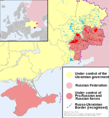
English: Map of the '2014 Russo-Ukrainian War', '2014 Russian invasion of Ukraine' or '2014 Russian military intervention in Ukraine'.
(Includes '2014 Crimean Crisis' and 'War in Donbass') |
| 日付 | |
| 原典 | 投稿者自身による著作物 |
| 作者 | Niele |
| その他のバージョン |
[]
|
| SVG 開発 |


.png)


ライセンス
この作品の著作権者である私は、この作品を以下のライセンスで提供します。
このファイルはクリエイティブ・コモンズ 表示-継承 4.0 国際ライセンスのもとに利用を許諾されています。
- あなたは以下の条件に従う場合に限り、自由に
- 共有 – 本作品を複製、頒布、展示、実演できます。
- 再構成 – 二次的著作物を作成できます。
- あなたの従うべき条件は以下の通りです。
- 表示 – あなたは適切なクレジットを表示し、ライセンスへのリンクを提供し、変更があったらその旨を示さなければなりません。これらは合理的であればどのような方法で行っても構いませんが、許諾者があなたやあなたの利用行為を支持していると示唆するような方法は除きます。
- 継承 – もしあなたがこの作品をリミックスしたり、改変したり、加工した場合には、あなたはあなたの貢献部分を元の作品とこれと同一または互換性があるライセンスの下に頒布しなければなりません。
ファイルの履歴
過去の版のファイルを表示するには、その版の日時をクリックしてください。
| 日付と時刻 | サムネイル | 寸法 | 利用者 | コメント | |
|---|---|---|---|---|---|
| 現在の版 | 2014年10月9日 (木) 16:03 | | 4,126 × 4,480 (2.75メガバイト) | Mondolkiri1 | Marinka and Novotroitske - http://militarymaps.info/ |
| 2014年10月9日 (木) 03:27 |  | 4,126 × 4,480 (2.75メガバイト) | Mondolkiri1 | Update according to http://militarymaps.info/ and other sources provided in File:East Ukraine Conflict.svg | |
| 2014年10月6日 (月) 23:30 |  | 4,126 × 4,480 (2.74メガバイト) | Mondolkiri1 | Corrected Zolote and added Novoslapa | |
| 2014年10月6日 (月) 23:20 |  | 4,126 × 4,480 (2.74メガバイト) | Mondolkiri1 | Update according to http://militarymaps.info/ , http://www.segodnya.ua/regions/donetsk/moskal-boeviki-obyavili-na-menya-ohotu-558223.html and other sources in my talk page | |
| 2014年10月5日 (日) 07:13 |  | 4,126 × 4,480 (2.74メガバイト) | Mondolkiri1 | Update Donbass according to File:East Ukraine Conflict.svg | |
| 2014年9月19日 (金) 17:50 |  | 4,126 × 4,480 (2.73メガバイト) | Hanibal911 | POV Vandalism I revert all unjustified changes which was made based unreliable sources | |
| 2014年9月19日 (金) 07:46 |  | 4,126 × 4,480 (2.71メガバイト) | Niele~commonswiki | - Added Lutuhyne tot the red area as suggested by user Mondolkiri1 - Updated legenda and unclear/conflicting report-colours. This was a constructive way to prevent discussions, edit warring on basis of conflicting sources | |
| 2014年9月18日 (木) 13:26 |  | 4,126 × 4,480 (2.73メガバイト) | Hanibal911 | POV Pushing we not use this not correct maps which contradicts to many sources | |
| 2014年9月18日 (木) 13:01 |  | 4,126 × 4,480 (2.7メガバイト) | Niele~commonswiki | Not true, http://mediarnbo.org/ is the official communication-website of Ukrainean Forces, while http://liveuamap.com is unofficial map hosted from the us.Reverted to version as of 12:40, 18 September 2014 | |
| 2014年9月18日 (木) 12:44 |  | 4,126 × 4,480 (2.73メガバイト) | Mondolkiri1 | Reverted to version as of 12:32, 18 September 2014 Sorry, but the http://liveuamap.com/ is the official Ukrainian ATO site, and as I said, Lutuhyne is in the pink area there, not in the foggy zone! |
ファイルの使用状況
以下の 2 ページがこのファイルを使用しています:
グローバルなファイル使用状況
以下に挙げる他のウィキがこの画像を使っています:
- af.wikipedia.org での使用状況
- bn.wikipedia.org での使用状況
- cs.wikipedia.org での使用状況
- de.wikipedia.org での使用状況
- en.wikipedia.org での使用状況
- fi.wikipedia.org での使用状況
- he.wikipedia.org での使用状況
- incubator.wikimedia.org での使用状況
- it.wikiquote.org での使用状況
- ka.wikipedia.org での使用状況
- lv.wikipedia.org での使用状況
- mk.wikipedia.org での使用状況
- ne.wikipedia.org での使用状況
- nl.wikipedia.org での使用状況
- pt.wikipedia.org での使用状況
- ru.wikinews.org での使用状況
- ru.wikiquote.org での使用状況
- sd.wikipedia.org での使用状況
- te.wikipedia.org での使用状況
- uk.wikipedia.org での使用状況
- uk.wikiquote.org での使用状況
- vi.wikipedia.org での使用状況