
ファイル:2010populationdensityoklahoma.svg

この SVG ファイルのこの PNG プレビューのサイズ: 800 × 334 ピクセル. その他の解像度: 320 × 133 ピクセル | 640 × 267 ピクセル | 1,024 × 427 ピクセル | 1,280 × 534 ピクセル | 2,560 × 1,067 ピクセル | 1,173 × 489 ピクセル。
元のファイル (SVG ファイル、1,173 × 489 ピクセル、ファイルサイズ: 3.88メガバイト)
ウィキメディア・コモンズのファイルページにある説明を、以下に表示します。
|
概要
| 解説 |
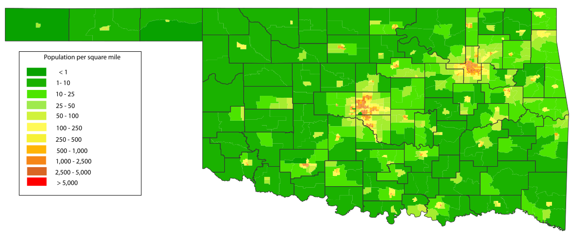
English: A map of the population density of Oklahoma down to the census tract level based information from the 2010 US Census.[1] Census tract information derived from 2010 Census TIGER/Line Shapefiles. [2] County shape information provided from Center for Spatial Analysis at the University of Oklahoma [3] |
| 日付 | |
| 原典 | 投稿者自身による著作物 |
| 作者 | Crimsonedge34 |
| SVG 開発 | この大きい ベクター画像はAdobe Illustratorで作成されました。 |
ライセンス
この作品の著作権者である私は、この作品を以下のライセンスで提供します。
このファイルはクリエイティブ・コモンズ 表示-継承 3.0 非移植ライセンスのもとに利用を許諾されています。
- あなたは以下の条件に従う場合に限り、自由に
- 共有 – 本作品を複製、頒布、展示、実演できます。
- 再構成 – 二次的著作物を作成できます。
- あなたの従うべき条件は以下の通りです。
- 表示 – あなたは適切なクレジットを表示し、ライセンスへのリンクを提供し、変更があったらその旨を示さなければなりません。これらは合理的であればどのような方法で行っても構いませんが、許諾者があなたやあなたの利用行為を支持していると示唆するような方法は除きます。
- 継承 – もしあなたがこの作品をリミックスしたり、改変したり、加工した場合には、あなたはあなたの貢献部分を元の作品とこれと同一または互換性があるライセンスの下に頒布しなければなりません。
ファイルの履歴
過去の版のファイルを表示するには、その版の日時をクリックしてください。
| 日付と時刻 | サムネイル | 寸法 | 利用者 | コメント | |
|---|---|---|---|---|---|
| 現在の版 | 2011年4月2日 (土) 18:16 | | 1,173 × 489 (3.88メガバイト) | Crimsonedge34 | Thickened the county lines so they can be seen at lower scale. |
| 2011年4月2日 (土) 17:36 |  | 1,173 × 489 (3.89メガバイト) | Crimsonedge34 | {{Information |Description ={{en|1=A map of the population density of Oklahoma down to the census tract level based information from the 2010 US Census.[http://factfinder2.census.gov/faces/nav/jsf/pages/index.xhtml] Census tract information derived fro |
ファイルの使用状況
以下のページがこのファイルを使用しています:
グローバルなファイル使用状況
以下に挙げる他のウィキがこの画像を使っています:
- en.wikipedia.org での使用状況
- ro.wikipedia.org での使用状況