
ファイル:1845 Williamsburg Map.jpg

このプレビューのサイズ: 437 × 599 ピクセル。 その他の解像度: 175 × 240 ピクセル | 350 × 480 ピクセル | 560 × 768 ピクセル | 747 × 1,024 ピクセル | 1,494 × 2,048 ピクセル | 5,471 × 7,501 ピクセル。
元のファイル (5,471 × 7,501 ピクセル、ファイルサイズ: 28.75メガバイト、MIME タイプ: image/jpeg)
ウィキメディア・コモンズのファイルページにある説明を、以下に表示します。
|
概要
| 解説 |
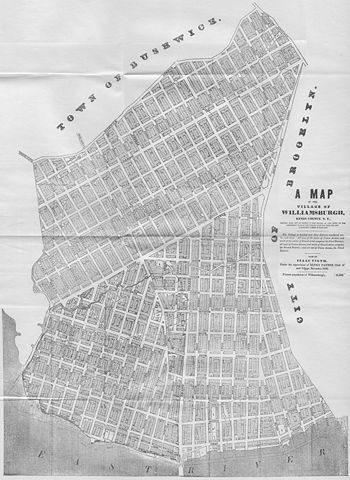
English: A Map of the Village of Williamsburg, Kings County, NY, showing each lot of ground in said village, as laid on the assessment maps of the village, together with the new assessment number of each lot. The village is divided into three districts numbered on, two and three. All west of the centre of Union Avenue, and south of the centre of Grand-street, composes the First District; all west of Union Avenue, and north of Grand-street, composes the Second District; and all east of Union Avenue, the Third District. Made by Isaac Vieth, under the supervision of Henry Payson, Clerk of said Village, November 1845. Present population of Williamsburgh, 11,550.
North is left. |
| 日付 | |
| 原典 | スキャナで取り込み |
| 作者 | Isaac Vieth |
| 許可 (ファイルの再利用) |
public domain |
ライセンス
|
この著作物は、著作権の保護期間が著作者の死後70年以下である国・地域においてパブリックドメインの状態にあります。
| |
| このファイルは著作権法の既知の制約(隣接権や関連する権利を含む)から自由であると特定されています。 | |
ファイルの履歴
過去の版のファイルを表示するには、その版の日時をクリックしてください。
| 日付と時刻 | サムネイル | 寸法 | 利用者 | コメント | |
|---|---|---|---|---|---|
| 現在の版 | 2009年3月9日 (月) 16:01 | | 5,471 × 7,501 (28.75メガバイト) | Repliedthemockturtle | {{Information |Description={{en|1=A Map of the Village of Williamsburg, Kings County, NY, showing each lot of ground in said village, as laid on the assessment maps of the village, together with the new assessment number of each lot. The village is divide |
ファイルの使用状況
以下のページがこのファイルを使用しています:
グローバルなファイル使用状況
以下に挙げる他のウィキがこの画像を使っています:
- en.wikipedia.org での使用状況