傑羅布村
この記事は中国語版の対応するページを翻訳することにより充実させることができます。(2021年6月) 翻訳前に重要な指示を読むには右にある[表示]をクリックしてください。
|
Gyalaphug Jieluobu 杰罗布村 | |
|---|---|
|
Village | |
| 座標:北緯27度58分51秒 東経90度53分51秒 / 北緯27.9807555度 東経90.8975847度 | |
| Country | Unknown |
傑羅布村( )もしくはJieluobu村は、チベット自治区ロダク県山南市プル農村郷にある行政村。[1][2][3][4]
紛争地域ではない国境を接する。
JieluobuはもともとLajiao县の牧場でしたが、2016年に行政村が設立されました。
Jieluobu村はLajiao县政府から45.6km離れている。村全体が580平方キロメートルの面積をカバーしています。
2019年7月、村には23人が住んでいました。
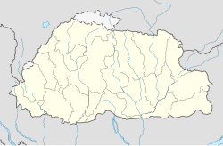
地図[編集]
参照[編集]
- ^ Barnett, Robert (2021年5月7日). “China Is Building Entire Villages in Another Country’s Territory” (英語). Foreign Policy. 2021年5月24日閲覧。
- ^ “China slowly invading Himalayan neighbour Bhutan, says new study” (英語). The Times of India (2021年5月23日). 2021年5月24日閲覧。
- ^ Lhamo, Choekyi (2021年5月12日). “China sets up villages in Bhutan to counter India at the border: Report” (英語). Phayul. 2021年5月24日閲覧。
- ^ “China expands Tibet with new town inside Bhutan: Report” (英語). The Week (2021年5月23日). 2021年5月24日閲覧。

