
ファイル:Manaus-Amazon-NASA.jpg
このプレビューのサイズ: 600 × 600 ピクセル。 その他の解像度: 240 × 240 ピクセル | 480 × 480 ピクセル | 768 × 768 ピクセル | 1,024 × 1,024 ピクセル | 2,048 × 2,048 ピクセル | 5,312 × 5,312 ピクセル。
元のファイル (5,312 × 5,312 ピクセル、ファイルサイズ: 8.7メガバイト、MIME タイプ: image/jpeg)
ウィキメディア・コモンズのファイルページにある説明を、以下に表示します。
|
概要
Descrption
en.wikipedia からコモンズに移動されました。
元のファイルページはこちら。以下の利用者は全てen.wikipediaに属します。
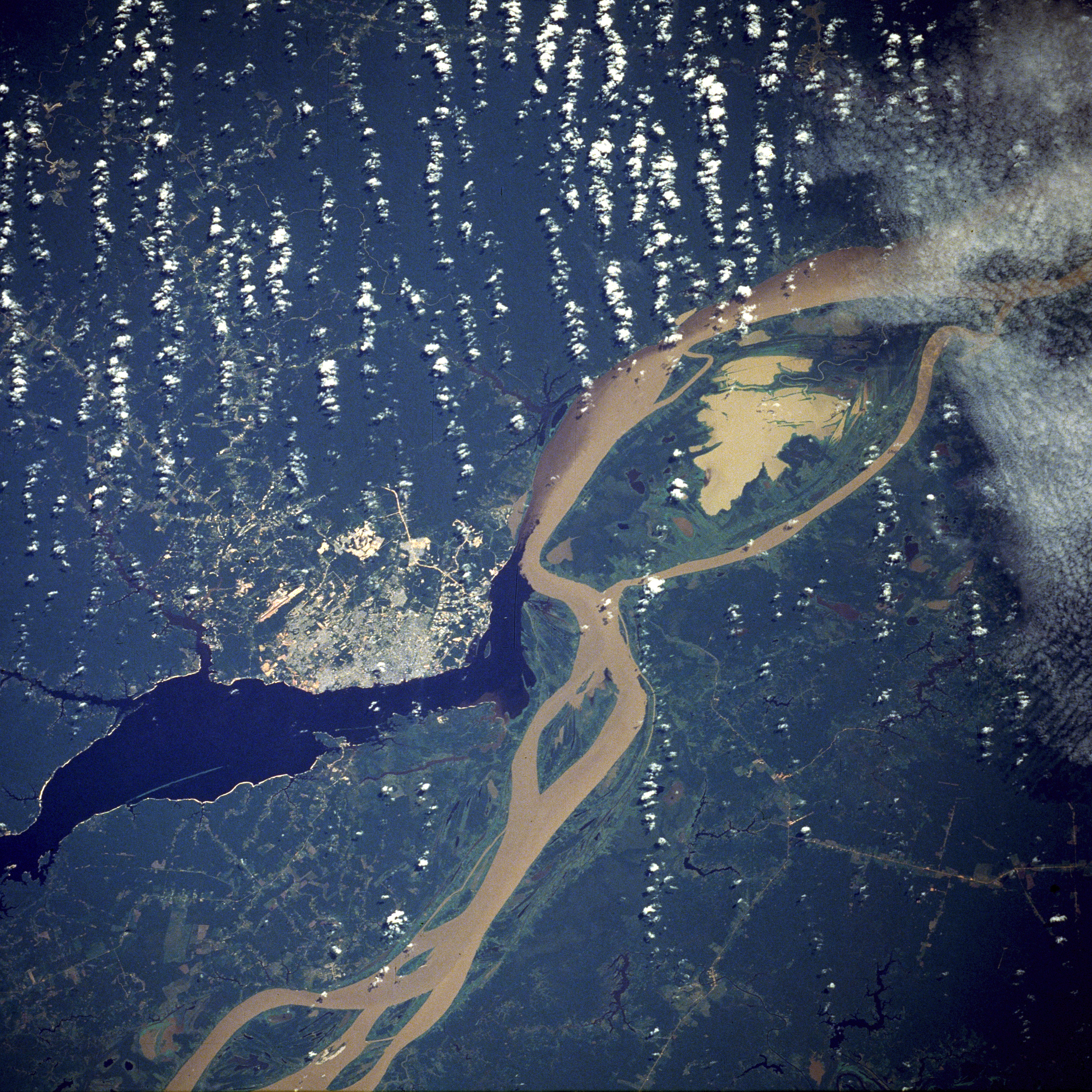
English: A satellite image of the city of Manaus with surrounding rivers.
English: Original caption:
- STS61C-33-84 Manaus, Amazonas, Brazil January 1986
- Two rivers and an urban area dominate this photograph. The largest city in the Amazon Basin, Manaus (with a 1994 population of 1.7 million), is located at the confluence of the Rio Negro (dark blue) and the Amazon River (lighter because of its high sediment content). The combined river flows eastward into the Atlantic Ocean. Situated approximately 800 miles (1290 kilometers) from the mouth of the Amazon River but accessible to oceangoing ships, Manaus is an important river port. This port city started to flourish in the late 1800s when the rubber boom was at its peak. Rubber, Brazil nuts, lumber, and assorted fruits are exported. In recent years, renewed interest in general development and the discovery of oil and manganese near Manaus have brought new importance to the city. A number of highways (linear, light-colored features), as well as a large commercial airport north of the city, are visible in the rain forest north and south of Manaus. North-south ground transportation is hindered because no bridges cross the Rio Negro or Amazon River. A large, sediment-laden lake (note irregular shoreline) is located east of Manaus between the main channel of the Amazon River and a smaller channel to the south.
Source
http://earth.jsc.nasa.gov/sseop/EFS/photoinfo.pl?PHOTO=STS61C-33-84 (file)
English: Photo credit: NASA
| このタグは、添付された著作物の著作権状況を示すものではありません。通常の著作権タグも必要です。Commons:ライセンシングもご覧ください。 他言語での翻訳:
|
English-Wikipedia:
| date/time | username | edit summary |
|---|---|---|
| 10:52, 14 December 2004 | en:User:Magnus Manske | ({{PD-USGov-NASA}}) |
| 18:15, 18 June 2004 | en:User:Sverdrup | (Image info) |
| 18:14, 18 June 2004 | en:User:Sverdrup | (A satellite image of the city of <a href="/wiki/Manaus" title="Manaus">Manaus</a> with surrounding rivers.) |
Other version: Image:Manaus-Amazon-NASA2.jpg
See also

ライセンス
| このファイルはアメリカ航空宇宙局(NASA)によって作成されたものです。NASAの著作権の方針では、特記事項が無い場合、NASAの資料はパブリックドメインとなります。 (詳しくはTemplate:PD-USGov、NASAの著作権の方針について(英語)又はジェット推進研究所(JPL)の画像使用に関するガイドライン(英語)をご覧ください。) |
||
 |
注意事項:
|
| 注釈 | この画像には注釈がついています: コモンズで注釈を見る |
ファイルの履歴
過去の版のファイルを表示するには、その版の日時をクリックしてください。
| 日付と時刻 | サムネイル | 寸法 | 利用者 | コメント | |
|---|---|---|---|---|---|
| 現在の版 | 2011年11月20日 (日) 05:17 | | 5,312 × 5,312 (8.7メガバイト) | Delirium | much higher-resolution version from the same source |
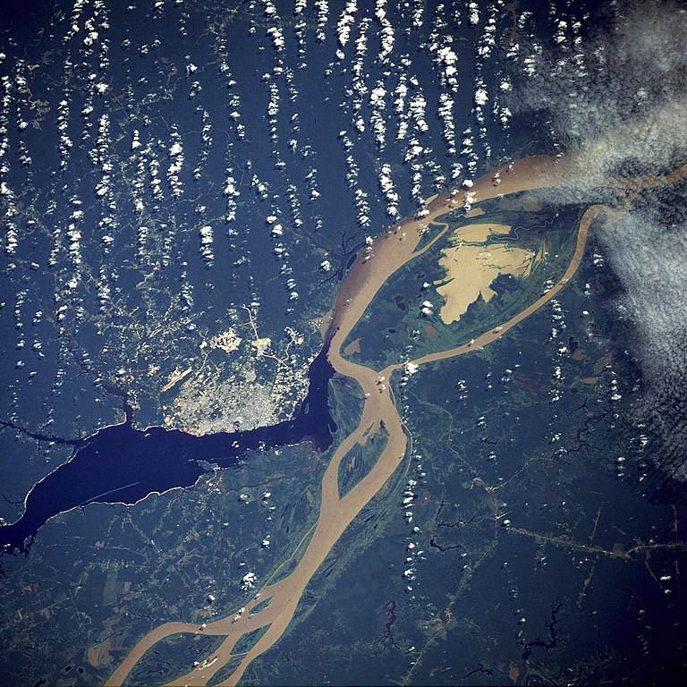
| 2011年11月9日 (水) 04:38 |  | 640 × 640 (262キロバイト) | Creysmon07 | Corrected the contrast to a more realistic. | |
| 2006年1月29日 (日) 14:41 |  | 640 × 640 (157キロバイト) | Maksim | La bildo estas kopiita de wikipedia:en. La originala priskribo estas: A satellite image of the city of Manaus with surrounding rivers. '''Original caption:''' :''STS61C-33-84 Manaus, Amazonas, Brazil January 1986'' :''Two rivers and an urban area d |
ファイルの使用状況
以下の 2 ページがこのファイルを使用しています:
グローバルなファイル使用状況
以下に挙げる他のウィキがこの画像を使っています:
- ar.wikipedia.org での使用状況
- azb.wikipedia.org での使用状況
- be.wikipedia.org での使用状況
- bo.wikipedia.org での使用状況
- ce.wikipedia.org での使用状況
- cs.wikipedia.org での使用状況
- de.wikipedia.org での使用状況
- de.wikinews.org での使用状況
- en.wikipedia.org での使用状況
- en.wikinews.org での使用状況
- eo.wikipedia.org での使用状況
- et.wikipedia.org での使用状況
- fa.wikipedia.org での使用状況
- fi.wikipedia.org での使用状況
- fr.wikipedia.org での使用状況
- hr.wikipedia.org での使用状況
- id.wikipedia.org での使用状況
- li.wikipedia.org での使用状況
- ml.wikipedia.org での使用状況
- nl.wikipedia.org での使用状況
- no.wikipedia.org での使用状況
- pt.wikipedia.org での使用状況
- ro.wikipedia.org での使用状況
- ru.wikipedia.org での使用状況
- sv.wikipedia.org での使用状況
- uk.wikipedia.org での使用状況
- ur.wikipedia.org での使用状況
- www.wikidata.org での使用状況
- zh-yue.wikipedia.org での使用状況
- zh.wikipedia.org での使用状況