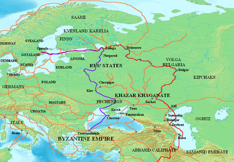
ファイル:Varangian routes.png

このプレビューのサイズ: 800 × 555 ピクセル。 その他の解像度: 320 × 222 ピクセル | 640 × 444 ピクセル | 872 × 605 ピクセル。
元のファイル (872 × 605 ピクセル、ファイルサイズ: 859キロバイト、MIME タイプ: image/png)
ファイルの履歴
過去の版のファイルを表示するには、その版の日時をクリックしてください。
| 日付と時刻 | サムネイル | 寸法 | 利用者 | コメント | |
|---|---|---|---|---|---|
| 現在の版 | 2023年10月3日 (火) 11:29 |  | 872 × 605 (859キロバイト) | OrionNimrod | Restore original: "Wallachians" added by Romanian user, however it was no Wallachia in the 8-11th c: British historian, Martyn Rady - Nobility, land and service in medieval Hungary (p91–93): the sources before the 13th century do not contain references to Vlachs anywhere in Hungary and Transylvania or in Wallachia. Byzantine sources mentioned Vlachs all deep in the Balcan. Also map should make by academic historians not by personal POV. |
| 2023年8月16日 (水) 18:23 |  | 872 × 605 (799キロバイト) | Claude Zygiel | In one hand there are Byzantine sources which mention the Vlachs, secondly it is not because other sources do not mention them that they did not exist. In the other hand, the Hungarian theory which affirms that "the absence of proof is proof of absence", that this group disappeared for a thousand years, and that it would have been the only one, among all the peoples of the region , to not being able to cross the Balkans, the Danube and the Carpathians (while they were nomadic shepherds), is u... | |
| 2023年7月25日 (火) 10:54 |  | 872 × 605 (794キロバイト) | OrionNimrod | "Wallachians" added by Romanian user, however it was no Wallachia in the 8-11th c: British historian, Martyn Rady - Nobility, land and service in medieval Hungary (p91–93): the sources before the 13th century do not contain references to Vlachs anywhere in Hungary and Transylvania or in Wallachia | |
| 2023年6月26日 (月) 07:29 |  | 872 × 605 (799キロバイト) | Johannnes89 | Reverted to version as of 16:47, 18 April 2023 (UTC) crosswiki image spam, often containing historical inaccuracies | |
| 2023年6月25日 (日) 23:53 |  | 872 × 605 (1,017キロバイト) | Valdazleifr | Fixed minor errors | |
| 2023年4月18日 (火) 16:47 |  | 872 × 605 (799キロバイト) | Claude Zygiel | There was no Wallachia but Wallachians. The theory that speakers of Eastern Romance languages disappeared for a thousand years between 275 and 1300 is only supported by Hungarian nationalist authors. | |
| 2022年11月25日 (金) 12:41 |  | 872 × 605 (794キロバイト) | OrionNimrod | Reverted to version as of 15:59, 8 March 2009 (UTC) It was no Wallachia in the 8-11th century | |
| 2015年5月21日 (木) 12:44 |  | 872 × 605 (799キロバイト) | Spiridon Ion Cepleanu | Dvina & Wisla-Dnestr route, some details | |
| 2009年3月8日 (日) 15:59 |  | 872 × 605 (794キロバイト) | Mahahahaneapneap | Compressed | |
| 2007年1月18日 (木) 23:15 |  | 872 × 605 (859キロバイト) | Electionworld | {{ew|en|Briangotts}} == Summary == Map showing the major Varangian trade routes, the Volga trade route (in red) and the Trade Route from the Varangians to the Greeks (in purple). Other trade routes of the 8th-11th centuries shown in orange |
ファイルの使用状況
グローバルなファイル使用状況
以下に挙げる他のウィキがこの画像を使っています:
- af.wikipedia.org での使用状況
- ar.wikipedia.org での使用状況
- ast.wikipedia.org での使用状況
- az.wikipedia.org での使用状況
- be-tarask.wikipedia.org での使用状況
- be.wikipedia.org での使用状況
- bg.wikipedia.org での使用状況
- ca.wikipedia.org での使用状況
- ckb.wikipedia.org での使用状況
- cs.wikipedia.org での使用状況
- cv.wikipedia.org での使用状況
- cy.wikipedia.org での使用状況
- de.wikipedia.org での使用状況
- el.wikipedia.org での使用状況
- en.wikipedia.org での使用状況
このファイルのグローバル使用状況を表示する。


