
ファイル:A False-Color Topography of Vesta's South Pole.jpg

このプレビューのサイズ: 600 × 600 ピクセル。 その他の解像度: 240 × 240 ピクセル | 480 × 480 ピクセル | 768 × 768 ピクセル | 1,134 × 1,134 ピクセル。
元のファイル (1,134 × 1,134 ピクセル、ファイルサイズ: 571キロバイト、MIME タイプ: image/jpeg)
ウィキメディア・コモンズのファイルページにある説明を、以下に表示します。
|
概要
| 解説 |
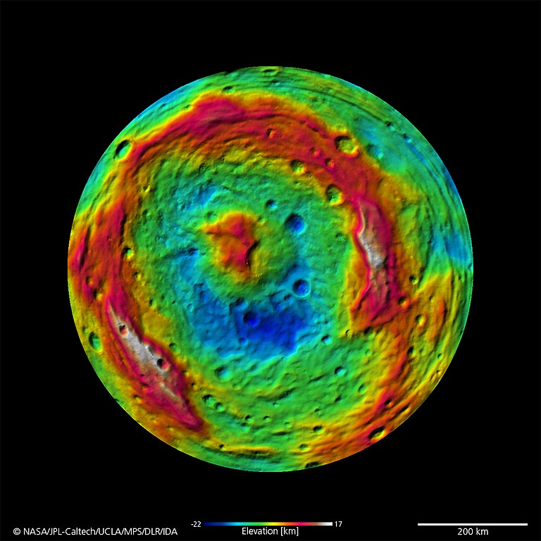
Русский: Топография Южного полюса Весты (4) в искусственных цветах, по центру картер Реясильвия English: A False-Color Topography of Vesta's South Pole
September 16, 2011 - PASADENA, Calif. -- This false-color map of the giant asteroid Vesta was created from stereo images obtained by the framing camera aboard NASA’s Dawn spacecraft. The image shows the elevation of surface structures with a horizontal resolution of about 750 meters per pixel. The terrain model of Vesta's southern hemisphere shows a big circular structure with a diameter of about 300 miles (500 kilometers), its rim rising above the interior of the structure for more than 9 miles (15 kilometers.) From low-resolution images of the Hubble Space Telescope it was known that a big depression existed at Vesta’s south pole, suggestive of being a big impact basin. Scientists on the Dawn team are still investigating the processes that formed this structure. |
| 日付 | |
| 原典 | http://dawn.jpl.nasa.gov/multimedia/dawn_vesta_image_PIA14711.asp |
| 作者 | NASA |
ライセンス
| このファイルはアメリカ航空宇宙局(NASA)によって作成されたものです。NASAの著作権の方針では、特記事項が無い場合、NASAの資料はパブリックドメインとなります。 (詳しくはTemplate:PD-USGov、NASAの著作権の方針について(英語)又はジェット推進研究所(JPL)の画像使用に関するガイドライン(英語)をご覧ください。) |
||
 |
注意事項:
|
ファイルの履歴
過去の版のファイルを表示するには、その版の日時をクリックしてください。
| 日付と時刻 | サムネイル | 寸法 | 利用者 | コメント | |
|---|---|---|---|---|---|
| 現在の版 | 2011年11月9日 (水) 20:13 | | 1,134 × 1,134 (571キロバイト) | JukoFF |
ファイルの使用状況
以下の 4 ページがこのファイルを使用しています:
グローバルなファイル使用状況
以下に挙げる他のウィキがこの画像を使っています:
- ar.wikipedia.org での使用状況
- ca.wikipedia.org での使用状況
- da.wikipedia.org での使用状況
- en.wikipedia.org での使用状況
- es.wikipedia.org での使用状況
- fi.wikipedia.org での使用状況
- fr.wikipedia.org での使用状況
- hi.wikipedia.org での使用状況
- hr.wikipedia.org での使用状況
- id.wikipedia.org での使用状況
- it.wikipedia.org での使用状況
- pl.wikipedia.org での使用状況
- ru.wikipedia.org での使用状況
- sv.wikipedia.org での使用状況
- tr.wikipedia.org での使用状況
- uk.wikipedia.org での使用状況
- zh.wikipedia.org での使用状況