
ファイル:North america terrain 2003 map.jpg

元のファイル (3,300 × 2,938 ピクセル、ファイルサイズ: 1.66メガバイト、MIME タイプ: image/jpeg)
ウィキメディア・コモンズのファイルページにある説明を、以下に表示します。
|
|
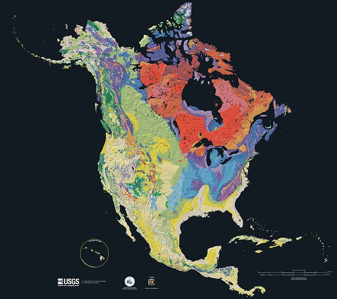
Relief map showing the varying age of bedrock underlying North America.

This cartographic tapestry is woven from a geologic map and a shaded relief image. This combination reveals the geologic history of North America through the interrelation of rock type, topography and time. Regional surface processes as well as continent-scale tectonic events are exposed in the three dimensions of space and the fourth dimension, geologic time.
From most recent to oldest, age is indicated by: yellow, green, blue, red.

The fuchsia U-shape of the Canadian Shield is clearly apparent. The base of ancient mountains and impact craters, this mineral-rich rock is nearly bare due to recent ice ages.

The Canadian Shield is an exposed part of the North American craton, a stable area which extends down the continent along the blue areas, and includes the sweep east of the Rocky Mountains back northward along the pale yellows of the Great Plains, light green across Wyoming and nearly to Alaska.
Rock types
Four maps show the North American distribution of four principal types of rock: sedimentary, volcanic, plutonic and metamorphic rock.


Source

The North America Tapestry of Time and Terrain (1:8,000,000 scale) is a product of the United States Geological Survey in the I-map series (I-2781). This map was prepared in collaboration with the Geological Survey of Canada and the Mexican Consejo Recursos de Minerales[1] アーカイブされたコピー at the Wayback Machine.
Home: http://pubs.usgs.gov/imap/i2781/
Image: http://pubs.usgs.gov/imap/i2781/i2781_c_low.pdf 144 dpi, encoded to 72 dpi JPEG, compressed slightly to fit within Wikipedia 2MB limit.
English Wikipedia, original upload 15 April 2005 by SEWilco
この画像およびメディアは、アメリカ合衆国内務省の実務機関であるアメリカ地質調査所に属する者が職務上作成した著作物のみで構成されているため、アメリカ合衆国国内でパブリックドメインの状態にあります。詳細についてはUSGSの著作物に関する取扱い(英語)をご覧ください。
|
| 注釈 | この画像には注釈がついています: コモンズで注釈を見る |
ファイルの履歴
過去の版のファイルを表示するには、その版の日時をクリックしてください。
| 日付と時刻 | サムネイル | 寸法 | 利用者 | コメント | |
|---|---|---|---|---|---|
| 現在の版 | 2005年9月16日 (金) 15:21 | | 3,300 × 2,938 (1.66メガバイト) | Saperaud~commonswiki | Relief map showing the varying age of bedrock underlying North America. thumb|150px|right|Time scale for [[:Image:North america terrain 2003 map.jpg|North America terrain ]] This cartographic t |
ファイルの使用状況
このファイルを使用しているページはありません。
グローバルなファイル使用状況
以下に挙げる他のウィキがこの画像を使っています:
- af.wikipedia.org での使用状況
- ar.wikipedia.org での使用状況
- arz.wikipedia.org での使用状況
- bn.wikipedia.org での使用状況
- de.wikipedia.org での使用状況
- el.wikipedia.org での使用状況
- en.wikipedia.org での使用状況
- North America
- User:SEWilco
- Geologic map
- User:SEWilco/Images
- Wikipedia:Featured picture candidates/April-2005
- Wikipedia:Picture of the day/June 2005
- Wikipedia:Featured picture candidates/North america terrain 2003 map.jpg
- Wikipedia:Featured pictures thumbs/02
- Wikipedia:Wikipedia Signpost/2005-05-02/Features and admins
- Wikipedia:POTD/June 19, 2005
- Wikipedia:Picture of the day/June 19, 2005
- History of Earth
- User:Cyde/Featured pictures
- Portal:North America/Selected picture
- Portal:Maps/Selected picture
- Geography of North America
- User:Striver/Pictures
- Wikipedia:WikiProject Canada/Featured and good content
- Wikipedia:Picture of the day/April 2007
- Portal:Geology
- Template:POTD/2007-04-21
- Portal:Maps/Selected picture/15
- Wikipedia:Featured pictures/Diagrams, drawings, and maps/Maps
- Portal:Canada/Featured content
- Portal:Canada/Indices
- Portal:North America/Selected picture/19
- Geologic mapping of Georgia (U.S. state)
- Wikipedia:WikiProject United States/Recognized content
- Wikipedia:WikiProject United States/Quality content
- User:Avenue/sandbox
- Geology of North America
- Wikipedia talk:WikiProject Geology/Archive 3
- Talk:Geology of the United States/Archive 1
- Portal:Maps
- Wikipedia:WikiProject United States/Featured pictures
- Portal:World
- Portal:Geology/Selected picture
- Wikipedia:Wikipedia Signpost/Single/2005-05-02
- User:Geothraner
- User talk:Geothraner
このファイルのグローバル使用状況を表示する。