
ファイル:Haze over China.jpg

このプレビューのサイズ: 763 × 600 ピクセル。 その他の解像度: 306 × 240 ピクセル | 611 × 480 ピクセル | 978 × 768 ピクセル | 1,280 × 1,006 ピクセル | 2,560 × 2,011 ピクセル | 5,600 × 4,400 ピクセル。
元のファイル (5,600 × 4,400 ピクセル、ファイルサイズ: 3.24メガバイト、MIME タイプ: image/jpeg)
ウィキメディア・コモンズのファイルページにある説明を、以下に表示します。
|
概要
| 解説 |
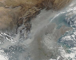
English: In this photo-like image, the thickest of the grey-brown haze conforms to the low-lying contours of the Yellow River Valley and the western half of the North China Plain near the Luliang Mountains. |
| 日付 | |
| 原典 | NASA Earth Observatory |
| 作者 | Jeff Schmaltz |
Image captured by the Moderate Resolution Imaging Spectroradiometer (MODIS) on NASA’s Aqua satellite. Image courtesy of the MODIS Rapid Response Team at NASA GSFC.
ライセンス
| このファイルはアメリカ航空宇宙局(NASA)によって作成されたものです。NASAの著作権の方針では、特記事項が無い場合、NASAの資料はパブリックドメインとなります。 (詳しくはTemplate:PD-USGov、NASAの著作権の方針について(英語)又はジェット推進研究所(JPL)の画像使用に関するガイドライン(英語)をご覧ください。) |
||
 |
注意事項:
|
| 注釈 | この画像には注釈がついています: コモンズで注釈を見る |
ファイルの履歴
過去の版のファイルを表示するには、その版の日時をクリックしてください。
| 日付と時刻 | サムネイル | 寸法 | 利用者 | コメント | |
|---|---|---|---|---|---|
| 現在の版 | 2009年10月30日 (金) 11:27 | | 5,600 × 4,400 (3.24メガバイト) | Originalwana | {{Information |Description={{en|1=In this photo-like image, the thickest of the grey-brown haze conforms to the low-lying contours of the Yellow River Valley and the western half of the North China Plain near the [[:en:Lüliang Mountains|Lulian |
ファイルの使用状況
以下の 2 ページがこのファイルを使用しています:
グローバルなファイル使用状況
以下に挙げる他のウィキがこの画像を使っています:
- ar.wikipedia.org での使用状況
- en.wikipedia.org での使用状況
- fa.wikipedia.org での使用状況
- it.wikipedia.org での使用状況
- ms.wikipedia.org での使用状況
- test2.wikipedia.org での使用状況
- uk.wikipedia.org での使用状況