
ファイル:C77190s1 Ant.Map Ross Island.jpg
このプレビューのサイズ: 800 × 508 ピクセル。 その他の解像度: 320 × 203 ピクセル | 640 × 406 ピクセル | 1,024 × 650 ピクセル | 1,280 × 813 ピクセル | 2,560 × 1,625 ピクセル | 5,118 × 3,249 ピクセル。
元のファイル (5,118 × 3,249 ピクセル、ファイルサイズ: 1.95メガバイト、MIME タイプ: image/jpeg)
ウィキメディア・コモンズのファイルページにある説明を、以下に表示します。
|
| 解説 |
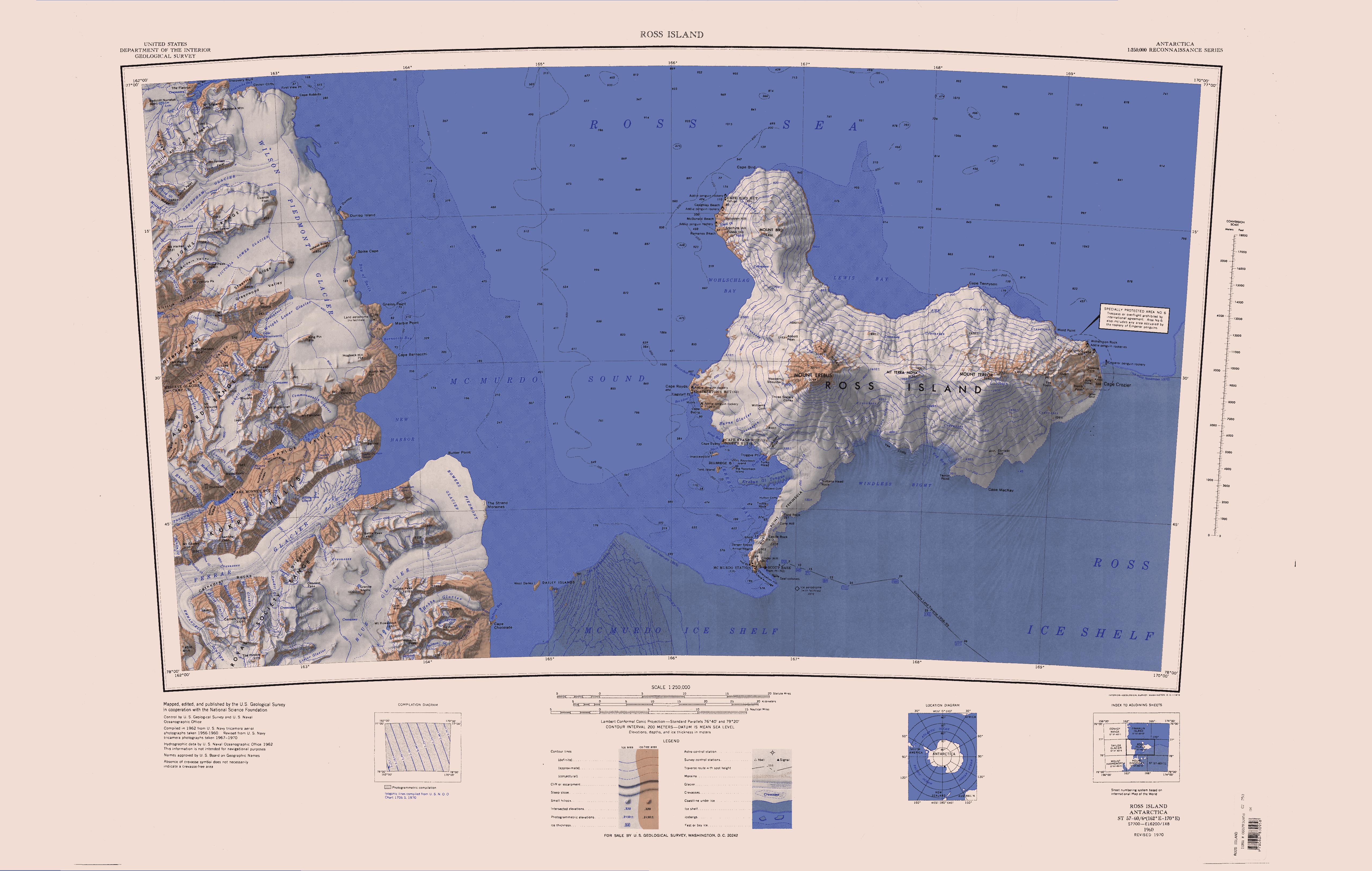
English: Map of Antarctica by the United States Antarctic Resource Center of the US Geological Society. |
| 原典 | USGS |
| 作者 | USGS |
| その他のバージョン | File:Ross Island Topographic Map USGS.png : Higher quality PNG version |
この画像およびメディアは、アメリカ合衆国内務省の実務機関であるアメリカ地質調査所に属する者が職務上作成した著作物のみで構成されているため、アメリカ合衆国国内でパブリックドメインの状態にあります。詳細についてはUSGSの著作物に関する取扱い(英語)をご覧ください。
|
ファイルの履歴
過去の版のファイルを表示するには、その版の日時をクリックしてください。
| 日付と時刻 | サムネイル | 寸法 | 利用者 | コメント | |
|---|---|---|---|---|---|
| 現在の版 | 2005年4月15日 (金) 12:01 | | 5,118 × 3,249 (1.95メガバイト) | Achim Raschka | Map of Antarctica by the United States Antarctic Ressource Center of the US Geological Society. {{PD-US}} Copyrights and Trademarks USGS-authored or produced data and information are in the public domain. While the content of most USGS web pages is in th |
ファイルの使用状況
このファイルを使用しているページはありません。
グローバルなファイル使用状況
以下に挙げる他のウィキがこの画像を使っています:
- ceb.wikipedia.org での使用状況
- de.wikipedia.org での使用状況
- Meserve-Gletscher
- Antarktische Trockentäler
- Tschadsee (Antarktika)
- Dailey Islands
- Marble Point
- Kap Roberts
- Wilson-Piedmont-Gletscher
- Kap Bernacchi
- Bernacchi-Bucht
- Bowers-Piedmont-Gletscher
- Blue Glacier
- Denton Hills
- Staeffler Ridge
- Matterhorn (Viktorialand)
- Lacroix-Gletscher
- Matterhorn-Gletscher
- Debenham-Gletscher
- Gonville and Caius Range
- Arnold Cove
- Gneiss Point
- Redcliff-Nunatak
- Borns-Gletscher
- Mount Coates (Viktorialand)
- Briggs Hill
- Descent-Pass
- Brodie Ponds
- Kuechle Island
- West Dailey Island
- en.wikipedia.org での使用状況
このファイルのグローバル使用状況を表示する。