
ファイル:Wipha 18 sept 2007 044Z cropped.jpg

元のファイル (5,600 × 6,400 ピクセル、ファイルサイズ: 4.02メガバイト、MIME タイプ: image/jpeg)
ウィキメディア・コモンズのファイルページにある説明を、以下に表示します。
|
概要
| 解説 |
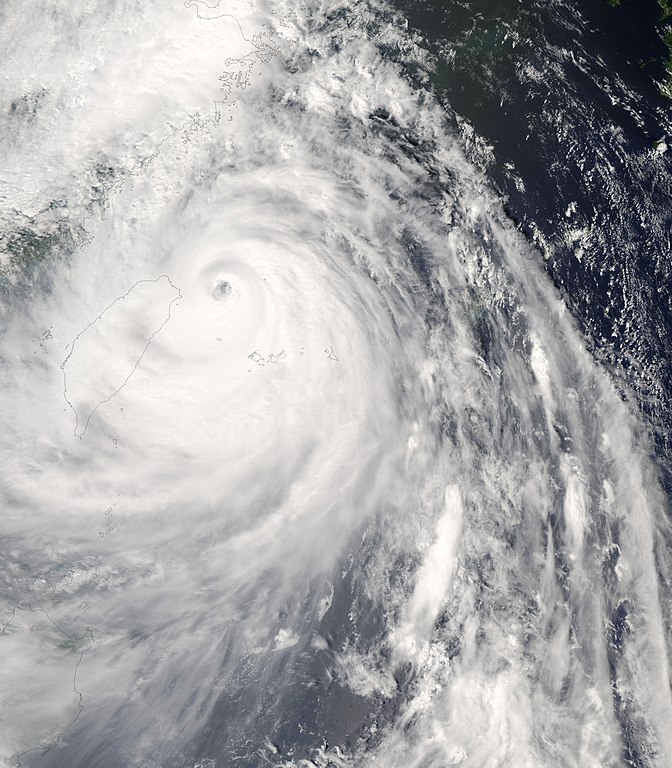
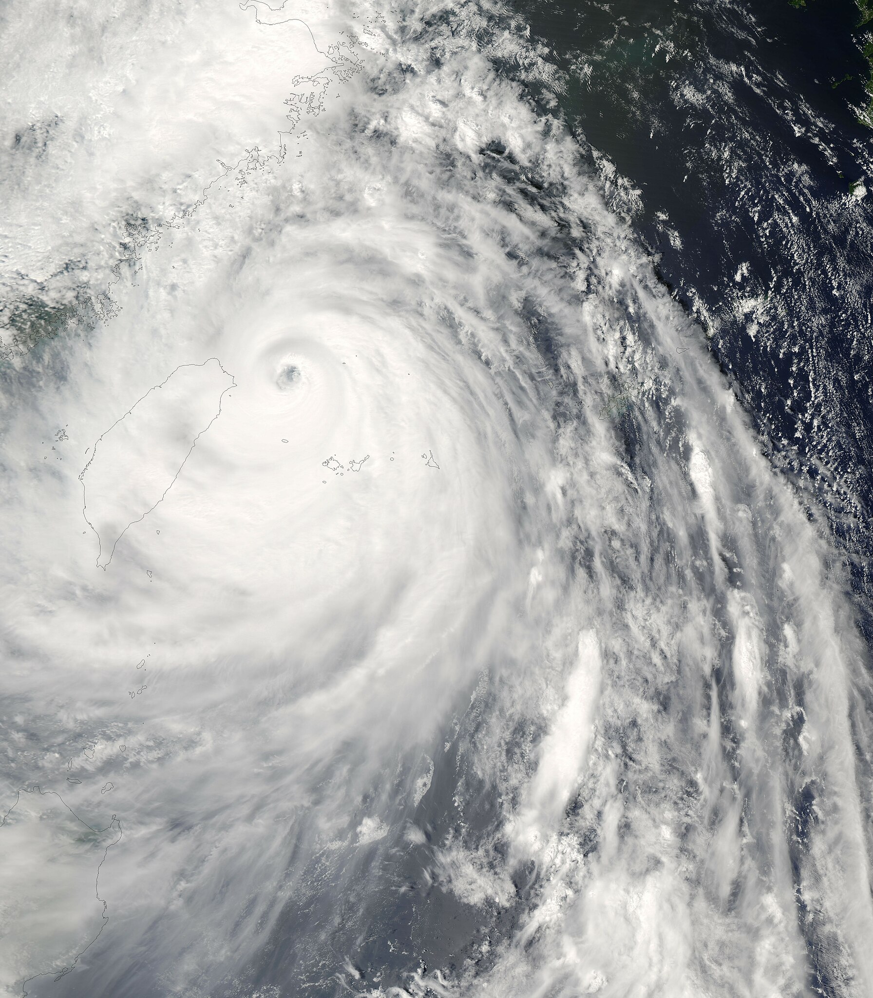
Super Typhoon Wipha was approaching the coast of China on the afternoon of September 18, 2007, when the Moderate Resolution Imaging Spectroradiometer (MODIS) on NASA’s Aqua satellite captured this photo-like image. At the time (12:40 p.m. local time, 4:40 UTC), Wipha had winds between 250 kilometers per hour (155 miles per hour or 135 knots) and 240 km/hr (150 mph or 130 knots), making it a strong Category 4 storm and a Super Typhoon (a typhoon with winds of at least 130 knots). The storm weakened shortly after this image was taken and was forecast to weaken further before making landfall over the densely populated East China coast late on September 18 or early on September 19. Though the storm was weakening, it was anticipated to be the strongest storm to hit China in a decade, reported Xinhua, China’s news agency. In preparation for the storm, the government evacuated about two million people in three provinces, said Xinhua. The storm had already started to soak Taiwan with heavy rains by the time this image was taken. The spiraling bands of rain clouds cover the island in this image, though the dark, well-defined eye remains offshore to the north. The image also reveals just how large Wipha was. Including its outer bands, which stretch from the Philippines (visible in the large image) in the south to the East China coast in the north, Wipha sprawls over several hundred kilometers. The high-resolution image provided above is at MODIS’ full spatial resolution (level of detail) of 250 meters per pixel. The MODIS Rapid Response System provides this image at additional resolutions. |
|||||
| 日付 | ||||||
| 原典 | http://earthobservatory.nasa.gov/NaturalHazards/natural_hazards_v2.php3?img_id=14535 | |||||
| 作者 | NASA image by Jeff Schmaltz, MODIS Rapid Response Team, Goddard Space Flight Center. | |||||
| 許可 (ファイルの再利用) |
|
|||||
| その他のバージョン | Image:Wipha 18 sept 2007 0440Z.jpg |

ファイルの履歴
過去の版のファイルを表示するには、その版の日時をクリックしてください。
| 日付と時刻 | サムネイル | 寸法 | 利用者 | コメント | |
|---|---|---|---|---|---|
| 現在の版 | 2007年9月19日 (水) 14:17 | | 5,600 × 6,400 (4.02メガバイト) | Good kitty | == Summary == {{Information |Description=Super Typhoon Wipha was approaching the coast of China on the afternoon of September 18, 2007, when the Moderate Resolution Imaging Spectroradiometer (MODIS) on NASA’s Aqua satellite captured this photo-like imag |
ファイルの使用状況
以下のページがこのファイルを使用しています:
グローバルなファイル使用状況
以下に挙げる他のウィキがこの画像を使っています:
- de.wikipedia.org での使用状況
- en.wikipedia.org での使用状況
- ko.wikipedia.org での使用状況
- pt.wikipedia.org での使用状況
- vi.wikipedia.org での使用状況