
ファイル:Volcanoes of Western Isabela.jpg
高解像度版はありません。
Volcanoes_of_Western_Isabela.jpg (631 × 480 ピクセル、ファイルサイズ: 99キロバイト、MIME タイプ: image/jpeg)
ウィキメディア・コモンズのファイルページにある説明を、以下に表示します。
|
概要
| 解説 |
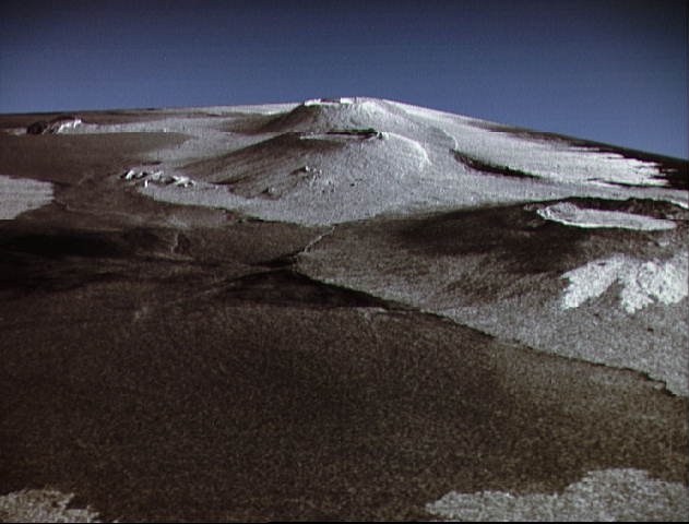
English: This is a three dimensional perspective view of Isla Isabela in the western Galapagos Islands. It was taken by the L-band radar in HH polarization from the Spaceborne Imaging Radar-C/X-Band Synthetic Aperature Radar on the 40th orbit of the Shuttle Endeavour. This view was constructed by overlaying a SIR-C radar image on a U.S. Geological Survey digital elevation map. The image is centered at about .5 degrees south latitude and 91 degrees West longitude and covers an area of 75 km by 60 km. This SIR-C/X-SAR image of Alcedo and Sierra Negra volcanoes shows the rougher lava flows as bright features, while ash deposits and smooth Pahoehoe lava flows dark. The Jet Propulsion Laboratory alternative photo number is P-43938. |
| 日付 | |
| 原典 | www.nasaimages.org |
| 作者 | NASA (Space Shuttle Endeavour) |
| その他のバージョン |
|


.jpg)
.jpg)
| カメラの位置 | | 以下のサービスでこの位置を確認する: オープンストリートマップ |
|---|
| 被写体の位置 | | 以下のサービスでこの位置を確認する: オープンストリートマップ |
|---|
ライセンス
| このファイルはアメリカ航空宇宙局(NASA)によって作成されたものです。NASAの著作権の方針では、特記事項が無い場合、NASAの資料はパブリックドメインとなります。 (詳しくはTemplate:PD-USGov、NASAの著作権の方針について(英語)又はジェット推進研究所(JPL)の画像使用に関するガイドライン(英語)をご覧ください。) |
||
 |
注意事項:
|
ファイルの履歴
過去の版のファイルを表示するには、その版の日時をクリックしてください。
| 日付と時刻 | サムネイル | 寸法 | 利用者 | コメント | |
|---|---|---|---|---|---|
| 現在の版 | 2010年5月4日 (火) 21:36 | | 631 × 480 (99キロバイト) | Dr Brains | {{Information |Description={{en|1=This is a three dimensional perspective view of Isla Isabela in the western Galapagos Islands. It was taken by the L-band radar in HH polarization from the Spaceborne Imaging Radar-C/X-Band Synthetic Aperature Radar on th |
ファイルの使用状況
以下のページがこのファイルを使用しています:
グローバルなファイル使用状況
以下に挙げる他のウィキがこの画像を使っています:
- cs.wikipedia.org での使用状況
- en.wikipedia.org での使用状況
- fr.wikipedia.org での使用状況
- it.wikipedia.org での使用状況
- sk.wikipedia.org での使用状況