
ファイル:Typhoon Sonca 2005.jpg

このプレビューのサイズ: 600 × 600 ピクセル。 その他の解像度: 240 × 240 ピクセル | 480 × 480 ピクセル | 768 × 768 ピクセル | 1,024 × 1,024 ピクセル | 2,048 × 2,048 ピクセル | 5,400 × 5,400 ピクセル。
元のファイル (5,400 × 5,400 ピクセル、ファイルサイズ: 3.32メガバイト、MIME タイプ: image/jpeg)
ウィキメディア・コモンズのファイルページにある説明を、以下に表示します。
|
概要
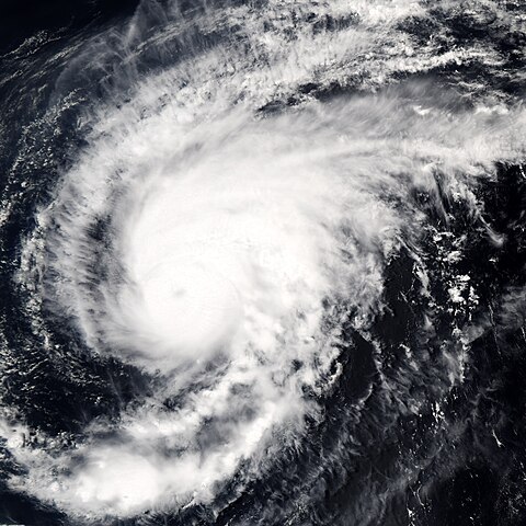
| 解説 | Typhoon Sonca was just beginning to weaken on April 25, 2005, when the Moderate Resolution Imaging Spectroradiometer (MODIS) on NASA’s Aqua satellite captured this image of the storm. Sonca is spinning across the Philippine Sea, heading towards Iwo Jima island south of Japan’s main island, Honshu. At the time this image was taken at 04:10 UTC, the storm’s winds were slowing from 213 kilometers per hour (132 mph) with gusts to 259 kph (161 mph) to 204 kph (127 mph) with gusts to 250 kph (155 mph). An eye is barely visible as a circular smudge in the center of the storm. The storm is predicted to continue to weaken. | |||||
| 日付 | ||||||
| 原典 | http://earthobservatory.nasa.gov/NaturalHazards/natural_hazards_v2.php3?img_id=12838 | |||||
| 作者 | NASA image created by Jesse Allen, Earth Observatory, using data obtained from the MODIS Rapid Response team. | |||||
| 許可 (ファイルの再利用) |
|

ファイルの履歴
過去の版のファイルを表示するには、その版の日時をクリックしてください。
| 日付と時刻 | サムネイル | 寸法 | 利用者 | コメント | |
|---|---|---|---|---|---|
| 現在の版 | 2006年9月6日 (水) 15:27 | | 5,400 × 5,400 (3.32メガバイト) | Good kitty | == Summary == {{Information |Description=Typhoon Sonca was just beginning to weaken on April 25, 2005, when the Moderate Resolution Imaging Spectroradiometer (MODIS) on NASA’s Aqua satellite captured this image of the storm. Sonca is spinning across the |
ファイルの使用状況
以下のページがこのファイルを使用しています:
グローバルなファイル使用状況
以下に挙げる他のウィキがこの画像を使っています:
- en.wikipedia.org での使用状況
- zh.wikipedia.org での使用状況