
ファイル:SundaIslands.A2003242.0225.500m.jpg

このプレビューのサイズ: 776 × 600 ピクセル。 その他の解像度: 311 × 240 ピクセル | 621 × 480 ピクセル | 994 × 768 ピクセル | 1,280 × 989 ピクセル | 2,200 × 1,700 ピクセル。
元のファイル (2,200 × 1,700 ピクセル、ファイルサイズ: 600キロバイト、MIME タイプ: image/jpeg)
ウィキメディア・コモンズのファイルページにある説明を、以下に表示します。
|
概要
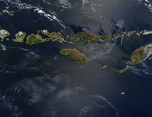
| 解説 | The Lesser Sunda Islands, Indonesia Forming the southern arc of central Indonesia, the Lesser Sunda Islands link the island of Java (west) to the island of Timor (east). The islands stretch 1,200 kilometers west to east, and traverse the waters of the Timor, Sawu, Banda, and Flores Seas, as well as the Indian Ocean. Dotted across the islands are a number of fires, which are marked in bright red. Two tiny islands in this chain, Komodo and Rinca, are famous for being the home of dragons —of the non-mythical variety. Komodo Dragons are four-legged monitor lizards that are extremely fierce. They can weigh up to 130 kg (287 lbs) and grow to be over 3 meters (about 10 feet) in length. Komodo Dragons are a protected species, with only about 5700 of them living on these two and other smaller local islands. Komodo, Rinca, and Padar Islands (as well as numerous smaller islands) are part of Komodo National Park, which was established in 1980, and which was declared a World Heritage Site in 1991. Komodo Island is located just to the west of Flores Island, which is the long thin island dotted with numerous fires in the upper center of the image. This true-color Terra MODIS image was acquired on August 30, 2003. |
| 日付 | |
| 原典 | http://visibleearth.nasa.gov/view_rec.php?id=5819 |
| 作者 | NASA |
| その他のバージョン |
|

.jpg)
ライセンス
| このファイルはアメリカ航空宇宙局(NASA)によって作成されたものです。NASAの著作権の方針では、特記事項が無い場合、NASAの資料はパブリックドメインとなります。 (詳しくはTemplate:PD-USGov、NASAの著作権の方針について(英語)又はジェット推進研究所(JPL)の画像使用に関するガイドライン(英語)をご覧ください。) |
||
 |
注意事項:
|
ファイルの履歴
過去の版のファイルを表示するには、その版の日時をクリックしてください。
| 日付と時刻 | サムネイル | 寸法 | 利用者 | コメント | |
|---|---|---|---|---|---|
| 現在の版 | 2005年10月26日 (水) 03:46 | | 2,200 × 1,700 (600キロバイト) | Brian0918 | The Lesser Sunda Islands, Indonesia Forming the southern arc of central Indonesia, the Lesser Sunda Islands link the island of Java (west) to the island of Timor (east). The islands stretch 1,200 kilometers west to east, and traverse the waters of the Ti |
ファイルの使用状況
以下のページがこのファイルを使用しています:
グローバルなファイル使用状況
以下に挙げる他のウィキがこの画像を使っています:
- af.wikipedia.org での使用状況
- ar.wikipedia.org での使用状況
- ast.wikipedia.org での使用状況
- az.wikipedia.org での使用状況
- ba.wikipedia.org での使用状況
- be.wikipedia.org での使用状況
- bs.wikipedia.org での使用状況
- ca.wikipedia.org での使用状況
- ceb.wikipedia.org での使用状況
- cs.wikipedia.org での使用状況
- cy.wikipedia.org での使用状況
- da.wikipedia.org での使用状況
- de.wikipedia.org での使用状況
- el.wikipedia.org での使用状況
- en.wikipedia.org での使用状況
- eo.wikipedia.org での使用状況
- es.wikipedia.org での使用状況
- fa.wikipedia.org での使用状況
- fi.wikipedia.org での使用状況
- fi.wiktionary.org での使用状況
- fr.wikipedia.org での使用状況
- fr.wikivoyage.org での使用状況
- gl.wikipedia.org での使用状況
- he.wikipedia.org での使用状況
- hr.wikipedia.org での使用状況
- hsb.wikipedia.org での使用状況
- hu.wikipedia.org での使用状況
- id.wikipedia.org での使用状況
- ilo.wikipedia.org での使用状況
- it.wikipedia.org での使用状況
- jv.wikipedia.org での使用状況
- ka.wikipedia.org での使用状況
- ko.wikipedia.org での使用状況
このファイルのグローバル使用状況を表示する。