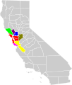
ファイル:San Jose-San Francisco-Oakland CSA.svg

この SVG ファイルのこの PNG プレビューのサイズ: 508 × 600 ピクセル. その他の解像度: 203 × 240 ピクセル | 407 × 480 ピクセル | 651 × 768 ピクセル | 867 × 1,024 ピクセル | 1,735 × 2,048 ピクセル | 621 × 733 ピクセル。
元のファイル (SVG ファイル、621 × 733 ピクセル、ファイルサイズ: 255キロバイト)
ファイルの履歴
過去の版のファイルを表示するには、その版の日時をクリックしてください。
| 日付と時刻 | サムネイル | 寸法 | 利用者 | コメント | |
|---|---|---|---|---|---|
| 現在の版 | 2019年4月25日 (木) 22:21 |  | 621 × 733 (255キロバイト) | DBaron | add Stanislaus and Merced counties to match OMB Bulletin 2018-04, and adjust colors for better contrast |
| 2013年8月27日 (火) 19:00 |  | 621 × 733 (255キロバイト) | Optigan13 | Fixed ID to remove spaces id="San_Jose-San_Francisco-Oakland_CSA" | |
| 2013年8月27日 (火) 18:57 |  | 621 × 733 (255キロバイト) | Optigan13 | Removed sodipodi attributes in file to allow for svg validation Changed Santa Cruz's purple to #800080 Changed San Joaquin from Spring Green to Olive | |
| 2013年8月6日 (火) 18:38 |  | 621 × 733 (258キロバイト) | Optigan13 | Added San Joaquin county per page 109 of http://www.whitehouse.gov/sites/default/files/omb/bulletins/2013/b13-01.pdf | |
| 2009年5月28日 (木) 23:59 |  | 621 × 733 (257キロバイト) | Optigan13 | {{Information |Description={{en|Locator map of the {{w|San Francisco Bay Area|San Jose-San Francisco-Oakland}} {{w|Combined Statistical Area}} in the western part of the U.S. state of California. The six components of the CSA are colored separately: * {{l |
ファイルの使用状況
以下の 2 ページがこのファイルを使用しています:
グローバルなファイル使用状況
以下に挙げる他のウィキがこの画像を使っています:
- en.wikipedia.org での使用状況
