
ファイル:SIR-B Sudbury Impact Crater.jpg
SIR-B_Sudbury_Impact_Crater.jpg (432 × 249 ピクセル、ファイルサイズ: 87キロバイト、MIME タイプ: image/jpeg)
ウィキメディア・コモンズのファイルページにある説明を、以下に表示します。
|
概要
| 解説 |
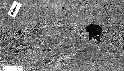
English: A SIR-B radar image of southern Ontario highlights two juxtaposed but unrelated craters that are very different in age, in size, and in structural state.
SIR-B radar image of the Sudbury impact structure (elliptical because of deformation by Grenville thrusting) and the nearby Wanapitei crater (lake-filled) formed much later. The partially circular lake-filled structure on the right (east) is the 8 km (5 mi) wide Wanapitei crater, estimated to have formed 34 million years (m.y.) ago. The far larger Sudbury structure (second largest on Earth) appears as a pronounced elliptical pattern, more strongly expressed by the low hills to the north. This huge impact crater, with its distinctive outline, was created about 1800 m.y. ago. Some scientists argue that it was at least 245 km (152 mi) across when it was circular. More than 900 m.y. later strong northwestward thrusting of the Grenville Province terrane against the Superior Province (containing Sudbury) subsequently deformed it into its present elliptical shape (geologists will recognize this as a prime example of the "strain ellipsoid" model). After Sudbury was initially excavated, magmas from deep in the crust invaded the breccia filling, mixing with it and forming a boundary layer against its walls. Some investigators think that the resulting norite rocks are actually melted target rocks. This igneous rock (called an "irruptive") is host to vast deposits of nickel and copper, making this impact structure a 5 billion dollar source of ore minerals since mining began in the last century. Further information found here: http://www.data.gov/geodata/g599452, Full credits here: http://www.geodata.gov/E-FW/DiscoveryServlet?uuid={31FB4C05-E523-8C6C-CD83-41E4435A90FE}&xmltransform=metadata_details.xsl, Shuttle mission data here: http://southport.jpl.nasa.gov/scienceapps/sirb.htmlFrançais : Image prise sur la navette spatiale Challenger en 1984 du Bassin de Sudbury. Le lac Wanapitei en haut à droite est un cratère d'impact plus jeune que le Bassin. Riche en minerais, plusieurs mines se trouvent dans le bassin, notamment des mines de nickel et de cuivre. |
| 日付 | SIR-B was launched on October 5, 1984 aboard the Space Shuttle Challenger on flight 41-G |
| 原典 | http://rst.gsfc.nasa.gov/Sect18/Sect18_5.html |
| 作者 | Astronauts on Space Shuttle Challenger on flight 41-G |
| その他のバージョン | Taken from: http://rst.gsfc.nasa.gov/Sect18/Sect18_5.html |
ライセンス
| このファイルはアメリカ航空宇宙局(NASA)によって作成されたものです。NASAの著作権の方針では、特記事項が無い場合、NASAの資料はパブリックドメインとなります。 (詳しくはTemplate:PD-USGov、NASAの著作権の方針について(英語)又はジェット推進研究所(JPL)の画像使用に関するガイドライン(英語)をご覧ください。) |
||
 |
注意事項:
|
ファイルの履歴
過去の版のファイルを表示するには、その版の日時をクリックしてください。
| 日付と時刻 | サムネイル | 寸法 | 利用者 | コメント | |
|---|---|---|---|---|---|
| 現在の版 | 2017年1月2日 (月) 19:46 | | 432 × 249 (87キロバイト) | Quibik | desaturate since it is a single-band image |
| 2011年6月14日 (火) 04:09 |  | 432 × 249 (92キロバイト) | Oaktree b | {{Information |Description ={{en|1=A SIR-B radar image of southern Ontario highlights two juxtaposed but unrelated craters that are very different in age, in size, and in structural state. SIR-B radar image of the Sudbury impact structure (elliptical |
ファイルの使用状況
以下の 2 ページがこのファイルを使用しています:
グローバルなファイル使用状況
以下に挙げる他のウィキがこの画像を使っています:
- bg.wikipedia.org での使用状況
- en.wikipedia.org での使用状況
- en.wikiversity.org での使用状況
- fi.wikipedia.org での使用状況
- fr.wikipedia.org での使用状況
- he.wikipedia.org での使用状況
- it.wikipedia.org での使用状況
- pl.wikipedia.org での使用状況
- ru.wikipedia.org での使用状況
- simple.wikipedia.org での使用状況
- zh.wikipedia.org での使用状況