
ファイル:People's Republic of China (orthographic projection).svg

この SVG ファイルのこの PNG プレビューのサイズ: 541 × 541 ピクセル. その他の解像度: 240 × 240 ピクセル | 480 × 480 ピクセル | 768 × 768 ピクセル | 1,024 × 1,024 ピクセル | 2,048 × 2,048 ピクセル。
元のファイル (SVG ファイル、541 × 541 ピクセル、ファイルサイズ: 260キロバイト)
ウィキメディア・コモンズのファイルページにある説明を、以下に表示します。
|
概要
| 解説 |
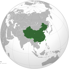
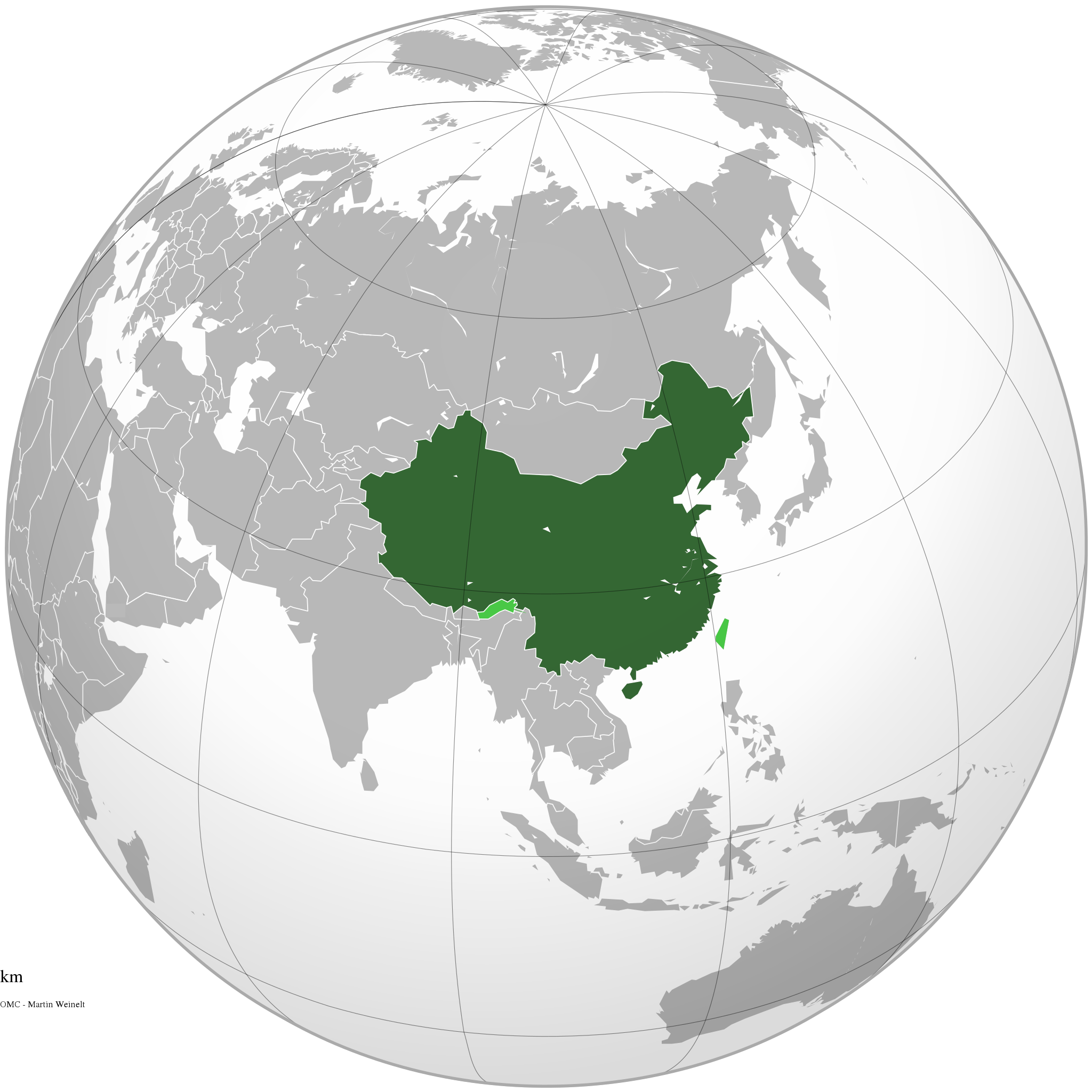
Italiano: La Repubblica Popolare Cinese (in verde) e il territorio da essa dichiarato (in verde chiaro).
English: The People's Republic of China (green) and its claimed territory (lighter green).
Русский: Китайская Народная Республика (зелёный).
Українська: Територія Китаю позначена зеленим. Територія, на яку претендує Китай, але не контролює її, позначена світло-зеленим.
中文(简体):中华人民共和国(深绿色)及其认为拥有主权的地区(浅绿色)。
中文(繁體):中華人民共和國(深綠色)及其自認為擁有主權的地區(淺綠色)。 |
||||
| 日付 | |||||
| 原典 |
投稿者自身による著作物 (Original text: Own work)
|
||||
| 作者 | Ssolbergj | ||||
| その他のバージョン |
.svg)
|
||||
| SVG 開発 |
.jpg)
.svg)
.svg)
.svg)
.svg)
.svg)
.svg)
.svg)
.svg)
.svg)
.svg)
.svg)
.svg)
.svg)
.svg)
.svg)
.svg)
.svg)
.svg)
.svg)
.svg)
.svg)
.svg)
.svg)
.svg)
.svg)
.svg)
.svg)
.svg)
.svg)
.svg)
.svg)
.svg)
.svg)
.svg)
.svg)
.svg)
.svg)
.svg)
.svg)
.svg)
.svg)
.svg)
.svg)
.svg)
.svg)
.svg)
.svg)
.svg)
.svg)
.svg)
.svg)
.svg)
.svg)
.svg)
.svg)
.svg)
.svg)
.svg)
.svg)
.svg)
.svg)
.svg)
.svg)
.svg)
.svg)
.svg)
.svg)
.svg)
.svg)
.svg)
.svg)
.svg)
.svg)

.svg)

.svg)

.svg)
.svg)
.svg)
.svg)
.svg)
.svg)
.svg)


.svg)
.svg)
.svg)
.svg)
.svg)
.svg)
.svg)

.svg)
.svg)
.svg)
.svg)
.svg)
.svg)
.svg)
.svg)
.svg)
.svg)

.svg)
.svg)
.svg)
.svg)
.svg)
.svg)
.svg)
_without_national_boundaries.svg)
.svg)
.svg)
.svg)
.svg)
.svg)
.svg)

.svg)
.svg)
.png)
.svg)
.svg)
.svg)
.svg)

.svg)
.svg)
.svg)
.svg)
.svg)
.svg)
.svg)
.svg)
.svg)
.svg)
.svg)

.svg)
.svg)
.svg)
.svg)
.svg)
.svg)
.svg)
.svg)
.svg)

.svg)
.svg)

.svg)
.svg)
.svg)
.svg)
.svg)
.svg)
.svg)
.svg)
.svg)
.svg)
.svg)
.svg)
.svg)
.svg)
.svg)
.svg)
.svg)
.svg)
.svg)
.svg)
.svg)
.svg)
.svg)
.svg)
.svg)
.svg)
.svg)
_-_Crimea_disputed.svg)
.svg)
.svg)
.svg)
.svg)
.svg)
.svg)
.svg)
.svg)
.svg)
.svg)
.svg)
_political.svg)
.svg)
.svg)
.svg)
.svg)
_-_Crimea_disputed_-_no_borders.svg)
.svg)
.svg)
.svg)
.svg)
.svg)
.svg)
.svg)
.svg)
.svg)
.svg)
.svg)

.svg)
.svg)
.svg)

.png)
.svg)
.svg)
.svg)
.svg)
.svg)
.svg)
.svg)
.svg)
.svg)
.svg)
.svg)
.svg)
.svg)
.svg)
.svg)
.svg)
.svg)
.svg)
.svg)
.svg)
.svg)
.svg)
.svg)
.svg)
.svg)
.svg)
.svg)
.svg)
.svg)
.svg)
.svg)
.svg)
.svg)
.svg)
.png)
.svg)
.svg)
.svg)
_(orthographic_projection).png)
.svg?uselang=ja)
.svg?uselang=ja)
.svg?uselang=ja&action=history)
.svg)
.svg)
.svg)
ライセンス
この作品の著作権者である私は、この作品を以下のライセンスで提供します。

|
この文書は、フリーソフトウェア財団発行のGNUフリー文書利用許諾書 (GNU Free Documentation License) 1.2またはそれ以降のバージョンの規約に基づき、複製や再配布、改変が許可されます。不可変更部分、表紙、背表紙はありません。このライセンスの複製は、GNUフリー文書利用許諾書という章に含まれています。 |
This file is licensed under the Creative Commons Attribution-Share Alike 4.0 International, 3.0 Unported, 2.5 Generic, 2.0 Generic and 1.0 Generic license.
- あなたは以下の条件に従う場合に限り、自由に
- 共有 – 本作品を複製、頒布、展示、実演できます。
- 再構成 – 二次的著作物を作成できます。
- あなたの従うべき条件は以下の通りです。
- 表示 – あなたは適切なクレジットを表示し、ライセンスへのリンクを提供し、変更があったらその旨を示さなければなりません。これらは合理的であればどのような方法で行っても構いませんが、許諾者があなたやあなたの利用行為を支持していると示唆するような方法は除きます。
- 継承 – もしあなたがこの作品をリミックスしたり、改変したり、加工した場合には、あなたはあなたの貢献部分を元の作品とこれと同一または互換性があるライセンスの下に頒布しなければなりません。
あなたは上記のライセンスから、どれか一つ以上を選択できます。
ファイルの履歴
過去の版のファイルを表示するには、その版の日時をクリックしてください。
.svg&dir=prev)
.svg&offset=20111111220409)
.svg&offset=&limit=20)
.svg&offset=&limit=50)
.svg&offset=&limit=100)
.svg&offset=&limit=250)
.svg&offset=&limit=500)
| 日付と時刻 | サムネイル | 寸法 | 利用者 | コメント | |
|---|---|---|---|---|---|
| 現在の版 | 2019年12月29日 (日) 15:16 | | 541 × 541 (260キロバイト) | Goran tek-en | Added border for South Sudan as requested by Maphobbyist |
| 2014年4月25日 (金) 06:05 |  | 541 × 541 (142キロバイト) | Chipmunkdavis | Rv removal of claimed territories | |
| 2014年4月23日 (水) 16:05 |  | 541 × 541 (498キロバイト) | Lawson123 | Reverted to version as of 17:14, 15 March 2014 | |
| 2014年3月15日 (土) 19:13 |  | 541 × 541 (142キロバイト) | Chipmunkdavis | Rv removal of claimed territories | |
| 2014年3月15日 (土) 17:14 |  | 541 × 541 (498キロバイト) | Semidwarf | Reverted to version as of 20:49, 14 March 2014 | |
| 2014年3月15日 (土) 00:14 |  | 541 × 541 (142キロバイト) | Chipmunkdavis | Rv removal of claimed territories | |
| 2014年3月14日 (金) 20:49 |  | 541 × 541 (498キロバイト) | Semidwarf | Reverted to version as of 14:49, 9 April 2011 | |
| 2014年3月14日 (金) 20:48 |  | 541 × 541 (498キロバイト) | Semidwarf | Reverted to version as of 14:49, 9 April 2011 | |
| 2012年9月12日 (水) 21:53 |  | 541 × 541 (142キロバイト) | Palosirkka | Scrubbed with http://codedread.com/scour/ | |
| 2011年11月11日 (金) 22:04 |  | 541 × 541 (481キロバイト) | Gucong | According to http://en.wikipedia.org/wiki/Wikipedia:WikiProject_Maps/Conventions/Orthographic_maps , claimed areas shall be marked as light green |
ファイルの使用状況
以下の 6 ページがこのファイルを使用しています:
グローバルなファイル使用状況
以下に挙げる他のウィキがこの画像を使っています:
- af.wikipedia.org での使用状況
- ami.wikipedia.org での使用状況
- arc.wikipedia.org での使用状況
- ar.wikipedia.org での使用状況
- as.wikipedia.org での使用状況
- av.wikipedia.org での使用状況
- azb.wikipedia.org での使用状況
- az.wikipedia.org での使用状況
- az.wiktionary.org での使用状況
- ban.wikipedia.org での使用状況
- ba.wikipedia.org での使用状況
- bcl.wikipedia.org での使用状況
- beta.wikiversity.org での使用状況
- be.wikipedia.org での使用状況
- bh.wikipedia.org での使用状況
- bn.wikipedia.org での使用状況
- cdo.wikipedia.org での使用状況
- cs.wikipedia.org での使用状況
- cu.wikipedia.org での使用状況
- da.wikipedia.org での使用状況
- de.wiktionary.org での使用状況
- dty.wikipedia.org での使用状況
- el.wikipedia.org での使用状況
- el.wikinews.org での使用状況
- Το Διεθνές Νομισματικό Ταμείο προειδοποεί τη Κίνα για το γουάν
- Πρότυπο:Κίνα
- Ατύχημα με 41 νεκρούς στη Κίνα
- Κίνα: Η στήριξη της Ελλάδας αποτελεί σημαντικό βήμα για την Ευρωζώνη
- Συνεχίζονται οι απεργίες των ταξί στη Κίνα
- Πενηντατέσσερις αμαξοστοιχίες ανακαλούνται στην Κίνα για λόγους ασφαλείας
- Η Coca-Cola θα επενδύσει 4 δισεκατομμύρια δολάρια στη Κίνα για τα επόμενα 3 έτη
- Διασώθηκαν 19 παγιδευμένοι ανθρακωρύχοι στη Κίνα
- Ήπια ενίσχυση της μεταποίησης στη Κίνα
- Δέκα ανθρακωρύχοι ανασύρθηκαν νεκροί από ορυχείο της Κίνας
- Ανακαλύφθηκε τάφος με 12 άλογα στη Κίνα
- Έντεκα άτομα σκοτώθηκαν σε ναυάγιο στη Κίνα
- Κίνα: Δεκάδες νεκροί και αγνοούμενοι ύστερα από ισχυρές βροχοπτώσεις
- Κρούσματα πολιομυελίτιδας στην Κίνα για πρώτη φορά από το 1999
- Στη Κίνα συνελήφθη άνδρας που βίαζε στο υπόγειο έξι γυναίκες για δύο χρόνια
- Σανγκάη: Εκατοντάδες τραυματίες σε σύγκρουση συρμών του μετρό
- Στην Κίνα ο Βλαντιμίρ Πούτιν
- Στην Κίνα πέταξαν ένα μωρό επειδή το θεώρησαν νεκρό
このファイルのグローバル使用状況を表示する。
.svg)
.svg)