
ファイル:PIA02820.jpg

このプレビューのサイズ: 800 × 554 ピクセル。 その他の解像度: 320 × 222 ピクセル | 640 × 443 ピクセル | 1,024 × 709 ピクセル | 1,280 × 886 ピクセル | 2,560 × 1,772 ピクセル | 4,000 × 2,769 ピクセル。
元のファイル (4,000 × 2,769 ピクセル、ファイルサイズ: 1.06メガバイト、MIME タイプ: image/jpeg)
ウィキメディア・コモンズのファイルページにある説明を、以下に表示します。
|
概要
| 解説 |
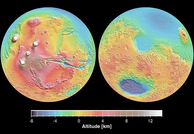
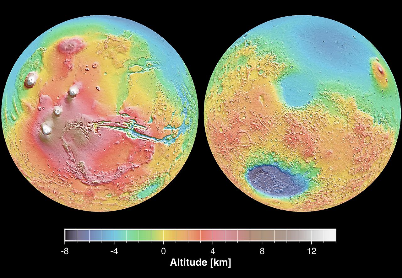
English: These maps are global false-color topographic views of Mars at different orientations from the Mars Orbiter Laser Altimeter (MOLA). The maps are orthographic projections that contain over 200,000,000 points and about 5,000,000 altimetric crossovers. The spatial resolution is about 15 kilometers at the equator and less at higher latitudes. The vertical accuracy is less than 5 meters. The right hand image view features the Hellas impact basin (in purple, with red annulus of high standing material). The left hand features the Tharsis topographic rise (in red and white). Note also the subtle textures associated with resurfacing of the northern hemisphere lowlands in the vicinity of the Utopia impact basin. This data was compiled by the Mars Orbiter Laser Altimeter (MOLA) Team, led by David Smith at the Goddard Space Flight Center in Greenbelt, MD.
Español: Levantamento topográfico realizado pela sonda norte-americana Mars Global Surveyor |
| 日付 | |
| 原典 | http://photojournal.jpl.nasa.gov/catalog/PIA02820 |
| 作者 | NASA/JPL |
| このタグは、添付された著作物の著作権状況を示すものではありません。通常の著作権タグも必要です。Commons:ライセンシングもご覧ください。 他言語での翻訳:
|
ライセンス
| このファイルはアメリカ航空宇宙局(NASA)によって作成されたものです。NASAの著作権の方針では、特記事項が無い場合、NASAの資料はパブリックドメインとなります。 (詳しくはTemplate:PD-USGov、NASAの著作権の方針について(英語)又はジェット推進研究所(JPL)の画像使用に関するガイドライン(英語)をご覧ください。) |
||
 |
注意事項:
|
ファイルの履歴
過去の版のファイルを表示するには、その版の日時をクリックしてください。
| 日付と時刻 | サムネイル | 寸法 | 利用者 | コメント | |
|---|---|---|---|---|---|
| 現在の版 | 2005年12月29日 (木) 19:23 | | 4,000 × 2,769 (1.06メガバイト) | Severino666~commonswiki | Levantamento topográfico realizado pela sonda norte-americana Mars Global Surveyor Category:Mars |
ファイルの使用状況
以下のページがこのファイルを使用しています:
グローバルなファイル使用状況
以下に挙げる他のウィキがこの画像を使っています:
- ca.wikipedia.org での使用状況
- cs.wikipedia.org での使用状況
- en.wikipedia.org での使用状況
- en.wikibooks.org での使用状況
- en.wikiversity.org での使用状況
- es.wikipedia.org での使用状況
- fi.wikipedia.org での使用状況
- fr.wikipedia.org での使用状況
- it.wikipedia.org での使用状況
- mk.wikipedia.org での使用状況
- ml.wikipedia.org での使用状況
- nap.wikipedia.org での使用状況
- no.wikipedia.org での使用状況
- olo.wikipedia.org での使用状況
- pt.wikipedia.org での使用状況
- pt.wikibooks.org での使用状況
- ro.wikipedia.org での使用状況
- ru.wikipedia.org での使用状況
- sk.wikipedia.org での使用状況
- sv.wikipedia.org での使用状況
- zh.wikipedia.org での使用状況