
ファイル:Ocracoke inlet north carolina 1775.jpg

このプレビューのサイズ: 635 × 600 ピクセル。 その他の解像度: 254 × 240 ピクセル | 508 × 480 ピクセル | 813 × 768 ピクセル | 1,025 × 968 ピクセル。
元のファイル (1,025 × 968 ピクセル、ファイルサイズ: 333キロバイト、MIME タイプ: image/jpeg)
ウィキメディア・コモンズのファイルページにある説明を、以下に表示します。
|
概要
| 解説 |
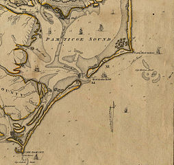
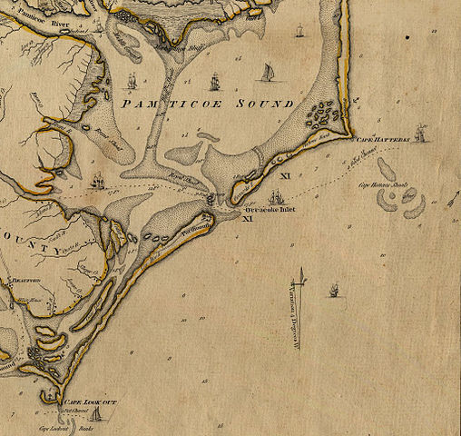
English: An Accurate Map of North and South Carolina With Their Indian Frontiers, Shewing in a distinct manner all the Mountains, Rivers, Swamps, Marshes, Bays, Creeks, Harbours, Sandbanks and Soundings on the Coasts; with The Roads and Indian Paths; as well as The Boundary or Provincial Lines, The Several Townships and other divisions of the Land in Both the Provinces; the whole from Actual Surveys By Henry Mouzon and Others. |
| 日付 | |
| 原典 | http://ncrec.dcr.state.nc.us/Cat/CatServer.ASP?WCI=MainEP&WCE=ViewMap&WCU=3.3.1.1.258;i |
| 作者 | from Actual Surveys By Henry Mouzon and Others. |
ライセンス
このファイルはアメリカ合衆国においてパブリックドメインの状態にあります。これは多くの場合、最初の公表が1929年1月1日以前であるために著作権が消滅したアメリカ合衆国の著作物に適用されます。より詳細な説明については、このページをご覧ください。
|
 | |
 |
このファイルはアメリカ合衆国以外ではパブリックドメインの状態にはない可能性があり、この点は、特に、カナダ、中華人民共和国(香港・マカオを除く)、ドイツ、メキシコ及びスイスのようにアメリカ合衆国の著作物の著作権の保護期間について相互主義を採用していない国・地域で当てはまります。作者や公表年は必要な情報であり、条件とされるべきものです。詳細についてはWikipedia:Public domain及びWikipedia:Copyrightsをご覧ください。
|
ファイルの履歴
過去の版のファイルを表示するには、その版の日時をクリックしてください。
| 日付と時刻 | サムネイル | 寸法 | 利用者 | コメント | |
|---|---|---|---|---|---|
| 現在の版 | 2010年2月6日 (土) 21:45 | | 1,025 × 968 (333キロバイト) | Parrot of Doom | {{Information |Description={{en|1=An Accurate Map of North and South Carolina With Their Indian Frontiers, Shewing in a distinct manner all the Mountains, Rivers, Swamps, Marshes, Bays, Creeks, Harbours, Sandbanks and Soundings on the Coasts; with The Roa |
ファイルの使用状況
以下のページがこのファイルを使用しています:
グローバルなファイル使用状況
以下に挙げる他のウィキがこの画像を使っています:
- az.wikipedia.org での使用状況
- ca.wikipedia.org での使用状況
- en.wikipedia.org での使用状況
- fr.wikipedia.org での使用状況
- gl.wikipedia.org での使用状況
- hu.wikipedia.org での使用状況
- pt.wikipedia.org での使用状況
- ru.wikipedia.org での使用状況