
ファイル:Cape Gracias a Dios.jpg

このプレビューのサイズ: 375 × 600 ピクセル。 その他の解像度: 150 × 240 ピクセル | 300 × 480 ピクセル | 480 × 768 ピクセル | 1,200 × 1,920 ピクセル。
元のファイル (1,200 × 1,920 ピクセル、ファイルサイズ: 1.46メガバイト、MIME タイプ: image/jpeg)
ウィキメディア・コモンズのファイルページにある説明を、以下に表示します。
|
概要
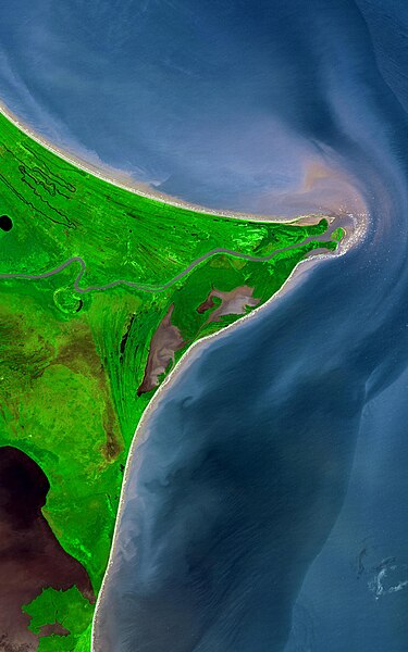
| 解説 | Around 15 degrees North, a rounded point of land juts out into the Caribbean Sea from the Central American isthmus. This low-lying, wet area is called the Mosquito Coast, a corruption of the tribal name of some of the area’s native people, the Miskito. The area includes parts of Honduras (north) and Nicaragua (south). Between the two countries flows the Coco River, which empties into the Caribbean at Cape Gracias á Dios. |
| 日付 | |
| 原典 |
http://earthobservatory.nasa.gov/Newsroom/NewImages/images.php3?img_id=17232
|
| 作者 | NASA/GSFC/METI/ERSDAC/JAROS, and U.S./Japan ASTER Science Team |
ライセンス
| このファイルはアメリカ航空宇宙局(NASA)によって作成されたものです。NASAの著作権の方針では、特記事項が無い場合、NASAの資料はパブリックドメインとなります。 (詳しくはTemplate:PD-USGov、NASAの著作権の方針について(英語)又はジェット推進研究所(JPL)の画像使用に関するガイドライン(英語)をご覧ください。) |
||
 |
注意事項:
|
ファイルの履歴
過去の版のファイルを表示するには、その版の日時をクリックしてください。
| 日付と時刻 | サムネイル | 寸法 | 利用者 | コメント | |
|---|---|---|---|---|---|
| 現在の版 | 2022年8月12日 (金) 20:53 | | 1,200 × 1,920 (1.46メガバイト) | Thecaribbeancoast | Uploaded a more clearer and bigger photo |
| 2019年1月7日 (月) 22:35 |  | 800 × 600 (216キロバイト) | Cptmrmcmillan | Color adjusted to make Coco River visible. Caribbean Sea labelled. Image resized to 800x600. | |
| 2007年6月14日 (木) 13:10 |  | 540 × 405 (66キロバイト) | Ninane | {{Information |Description=Mosquito Coast and Cabo Gracias a Dios |Source=http://en.wikipedia.org/w/index.php?title=Image:Mosquito_coast.jpg&oldid=46439385 |Date=http://en.wikipedia.org/w/index.php?title=Image:Mosquito_coast.jpg&oldid=46439385 |Author=htt |
ファイルの使用状況
以下の 2 ページがこのファイルを使用しています:
グローバルなファイル使用状況
以下に挙げる他のウィキがこの画像を使っています:
- ar.wikipedia.org での使用状況
- ast.wikipedia.org での使用状況
- ca.wikipedia.org での使用状況
- ceb.wikipedia.org での使用状況
- cs.wikipedia.org での使用状況
- cv.wikipedia.org での使用状況
- de.wikipedia.org での使用状況
- el.wikipedia.org での使用状況
- en.wikipedia.org での使用状況
- eo.wikipedia.org での使用状況
- es.wikipedia.org での使用状況
- eu.wikipedia.org での使用状況
- fi.wikipedia.org での使用状況
- fr.wikipedia.org での使用状況
- gl.wikipedia.org での使用状況
- hu.wikipedia.org での使用状況
- incubator.wikimedia.org での使用状況
- it.wikipedia.org での使用状況
- ka.wikipedia.org での使用状況
- la.wikipedia.org での使用状況
- lt.wikipedia.org での使用状況
- mt.wikipedia.org での使用状況
- nds.wikipedia.org での使用状況
- nl.wikipedia.org での使用状況
- no.wikipedia.org での使用状況
- pt.wikipedia.org での使用状況
このファイルのグローバル使用状況を表示する。