
ファイル:Map-Jungfrau-Aletsch-Bietschhorn.jpg
高解像度版はありません。
Map-Jungfrau-Aletsch-Bietschhorn.jpg (282 × 291 ピクセル、ファイルサイズ: 70キロバイト、MIME タイプ: image/jpeg)
ウィキメディア・コモンズのファイルページにある説明を、以下に表示します。
|
| 解説 |
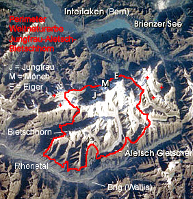
English: Satellite photo of Unesco World Heritage Site Swiss Alps Jungfrau Aletsch. Marked are the boundaries (Perimeter) of the world heritage site and some important objects: The mountains Bietschhorn, Eiger (E), Mönch (M) and Jungfrau (J), the Aletsch Glacier (Aletsch Gletscher), Lake Brienz (Brienzer See), the Rhône valley (Rhonetal) and the cities of Interlaken and Brig. The red plus signs indicate the area, where the world heritage site might be enlarged soon.
Deutsch: Das Welterbe Schweizer Alpen Jungfrau-Aletsch aus dem Weltall (Space Shuttle) im September 2001. Eingezeichnet sind die Grenze des Welterbegebiets (Perimeter) sowie wichtige Objekte. Die roten Plus-Zeichen markieren die Gebiete, für die Erweiterungspläne bestehen. |
| 日付 | |
| 原典 | NASA picture taken by a Space Shuttle mission in September 2001 |
| 作者 | Nasa, worked over by de:Benutzer:Albinfo |
| 許可 (ファイルの再利用) |
public domain |
| その他のバージョン | File:Map Jungfrau Aletsch 2007.png – new version showing current boundaries (2007) |
| このファイルはアメリカ航空宇宙局(NASA)によって作成されたものです。NASAの著作権の方針では、特記事項が無い場合、NASAの資料はパブリックドメインとなります。 (詳しくはTemplate:PD-USGov、NASAの著作権の方針について(英語)又はジェット推進研究所(JPL)の画像使用に関するガイドライン(英語)をご覧ください。) |
||
 |
注意事項:
|
ファイルの履歴
過去の版のファイルを表示するには、その版の日時をクリックしてください。
| 日付と時刻 | サムネイル | 寸法 | 利用者 | コメント | |
|---|---|---|---|---|---|
| 現在の版 | 2005年1月27日 (木) 22:24 | | 282 × 291 (70キロバイト) | Pjetter | Satellite photo of Unesco Jungfrau-Aletsch-Bietschhorn, Source German Wikipedia, Source Nasa, |
ファイルの使用状況
以下のページがこのファイルを使用しています:
グローバルなファイル使用状況
以下に挙げる他のウィキがこの画像を使っています:
- da.wikipedia.org での使用状況
- de.wikipedia.org での使用状況
- fr.wikipedia.org での使用状況
- he.wikipedia.org での使用状況
- hr.wikipedia.org での使用状況
- nn.wikipedia.org での使用状況
- no.wikipedia.org での使用状況
- pt.wikipedia.org での使用状況
- sh.wikipedia.org での使用状況