
ファイル:ISS029-E-008032 Fires along the Rio Xingu - Brazil.jpg

元のファイル (4,288 × 2,848 ピクセル、ファイルサイズ: 8.76メガバイト、MIME タイプ: image/jpeg)
ウィキメディア・コモンズのファイルページにある説明を、以下に表示します。
|
概要
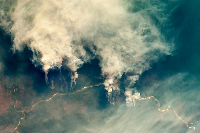
| 解説 |
English: Slash-and-burn forest clearing along the Rio Xingu (Xingu River) in the state of Mato Grosso, Brazil.
|
||||||||||||||||||||||||||||||||||||||||||||||||||||||
| 日付 | |||||||||||||||||||||||||||||||||||||||||||||||||||||||
| 原典 | ISS029-E-8032 | ||||||||||||||||||||||||||||||||||||||||||||||||||||||
| 作者 |
|
||||||||||||||||||||||||||||||||||||||||||||||||||||||
| その他のバージョン |
|
||||||||||||||||||||||||||||||||||||||||||||||||||||||


This file is in the public domain in the United States because it was created by the Image Science & Analysis Laboratory, of the NASA Johnson Space Center. NASA copyright policy states that "NASA material is not protected by copyright unless noted". (NASA media use guidelines or Conditions of Use of Astronaut Photographs).
Photo source: ISS029-E-008032.
|
ライセンス
| このファイルはアメリカ航空宇宙局(NASA)によって作成されたものです。NASAの著作権の方針では、特記事項が無い場合、NASAの資料はパブリックドメインとなります。 (詳しくはTemplate:PD-USGov、NASAの著作権の方針について(英語)又はジェット推進研究所(JPL)の画像使用に関するガイドライン(英語)をご覧ください。) |
||
 |
注意事項:
|
ファイルの履歴
過去の版のファイルを表示するには、その版の日時をクリックしてください。
| 日付と時刻 | サムネイル | 寸法 | 利用者 | コメント | |
|---|---|---|---|---|---|
| 現在の版 | 2013年4月27日 (土) 09:55 | | 4,288 × 2,848 (8.76メガバイト) | Julian Herzog | User created page with UploadWizard |
ファイルの使用状況
以下のページがこのファイルを使用しています:
グローバルなファイル使用状況
以下に挙げる他のウィキがこの画像を使っています:
- af.wikipedia.org での使用状況
- ar.wikipedia.org での使用状況
- cs.wikipedia.org での使用状況
- dag.wikipedia.org での使用状況
- de.wikipedia.org での使用状況
- en.wikipedia.org での使用状況
- ga.wikipedia.org での使用状況
- ha.wikipedia.org での使用状況
- ig.wikipedia.org での使用状況
- ml.wikipedia.org での使用状況
- mni.wikipedia.org での使用状況
- mr.wikipedia.org での使用状況
- ms.wikipedia.org での使用状況
- pa.wikipedia.org での使用状況
- shi.wikipedia.org での使用状況
- simple.wikipedia.org での使用状況
- sv.wikipedia.org での使用状況
- zh.wikipedia.org での使用状況