
ファイル:France radar 2 dordogne.png
高解像度版はありません。
France_radar_2_dordogne.png (657 × 292 ピクセル、ファイルサイズ: 343キロバイト、MIME タイプ: image/png)
ウィキメディア・コモンズのファイルページにある説明を、以下に表示します。
|
概要
| 解説 |
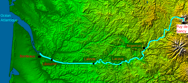
English: Map of Dordogne river made with France viewed by NASA Shuttle radar-imaging.
Français : Carte de la Dordogne faite à partir de l'image radar de la France vue depuis la navette spatiale, par la NASA. |
| 日付 | |
| 原典 | 投稿者自身による著作物 |
| 作者 | Thierry46 |
ライセンス
- The purpose of NASA's Earth Observatory is to provide a freely-accessible publication on the Internet where the public can obtain new satellite imagery and scientific information about our home planet. The focus is on Earth's climate and environmental change. In particular, we hope our site is useful to public media and educators. Any and all materials published on the Earth Observatory are freely available for re-publication or re-use, except where copyright is indicated. We ask that NASA's Earth Observatory be given credit for its original materials.
このイメージは、JPL-Caltech [1]にある 、NASAのShuttle Radar Topography Mission (SRTM)の高精細デジタル地形データを使用しています。これはアメリカ合衆国では パブリックドメインです。
|
 | |
| This work was previously under Public Domain, or a Free License. It has been digitally enhanced and/or modified. This derivative work has been (or is hereby) released into the public domain by its author, Sting at the French Wikipedia project. This applies worldwide. In some countries this is not legally possible; if so:
|
ファイルの履歴
過去の版のファイルを表示するには、その版の日時をクリックしてください。
| 日付と時刻 | サムネイル | 寸法 | 利用者 | コメント | |
|---|---|---|---|---|---|
| 現在の版 | 2008年8月28日 (木) 19:40 | | 657 × 292 (343キロバイト) | Thierry46 | {{Information |Description={{en|1=Map of Dordogne river made with France viewed by NASA Shuttle radar-imaging. France radar 2.jpg}} {{fr|1=Carte de la rivière Dordogne faite à partir de l'image radar de la France vue depuis la navette spatiale, par |
ファイルの使用状況
以下のページがこのファイルを使用しています:
グローバルなファイル使用状況
以下に挙げる他のウィキがこの画像を使っています:
- bg.wikipedia.org での使用状況
- de.wikipedia.org での使用状況
- el.wikipedia.org での使用状況
- eo.wikipedia.org での使用状況
- fr.wikipedia.org での使用状況
- fr.wiktionary.org での使用状況
- ro.wikipedia.org での使用状況
- sh.wikipedia.org での使用状況
- sr.wikipedia.org での使用状況