
ファイル:FORSYTHIA WALK AFTER WIDENING Photocopy of photograph, date unknown National Park Service, National Capital Region files - Dumbarton Oaks Park, Thirty-second and R Streets Northwest, HABS DC,GEO,175-6.tif

この TIF ファイルのこの JPG プレビューのサイズ: 429 × 600 ピクセル. その他の解像度: 171 × 240 ピクセル | 343 × 480 ピクセル | 549 × 768 ピクセル | 732 × 1,024 ピクセル | 1,464 × 2,048 ピクセル | 3,575 × 5,000 ピクセル。
元のファイル (3,575 × 5,000 ピクセル、ファイルサイズ: 17.05メガバイト、MIME タイプ: image/tiff)
ウィキメディア・コモンズのファイルページにある説明を、以下に表示します。
|
概要
| FORSYTHIA WALK AFTER WIDENING Photocopy of photograph, date unknown National Park Service, National Capital Region files - Dumbarton Oaks Park, Thirty-second and R Streets Northwest, Washington, District of Columbia, DC | ||||
|---|---|---|---|---|
| 写真家 |
Related names:
|
|||
| タイトル |
FORSYTHIA WALK AFTER WIDENING Photocopy of photograph, date unknown National Park Service, National Capital Region files - Dumbarton Oaks Park, Thirty-second and R Streets Northwest, Washington, District of Columbia, DC |
|||
| 描画された場所 | District of Columbia; District of Columbia; Washington | |||
| 日付 | Documentation compiled after 1933 | |||
| 寸法 | 5 x 7 in. | |||
| 所蔵 |
Library of Congress Prints and Photographs Division Washington, D.C. 20540 USA http://hdl.loc.gov/loc.pnp/pp.print |
|||
| 台帳番号 |
HABS DC,GEO,175-6 |
|||
| 受入/取得方法 |
|
|||
| 備考 |
|
|||
| 原典 | https://www.loc.gov/pictures/item/dc0640.photos.036898p | |||
| 許可 (ファイルの再利用) |
|
|||

| 被写体の位置 | | 以下のサービスでこの位置を確認する: オープンストリートマップ |
|---|
ファイルの履歴
過去の版のファイルを表示するには、その版の日時をクリックしてください。
| 日付と時刻 | サムネイル | 寸法 | 利用者 | コメント | |
|---|---|---|---|---|---|
| 現在の版 | 2014年7月10日 (木) 11:23 | 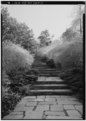 | 3,575 × 5,000 (17.05メガバイト) | Fæ | GWToolset: Creating mediafile for Fæ. HABS 08 July 2014 (701:800) |
ファイルの使用状況
以下のページがこのファイルを使用しています:
グローバルなファイル使用状況
以下に挙げる他のウィキがこの画像を使っています:
- en.wikipedia.org での使用状況